- Medicine Hat drone company gets $1.1M federal loan for weather and combat testing
- NWT publishes new flood maps for five communities
- One data centre or one million homes? Mapping Ontario’s proposed hyperscaler boom
- N.S. resident builds crowdsourced pothole map to promote civic responsibility
- Canada’s space commander on protecting satellites from jamming and potential nuclear risks
- NordSpace founder backs Wyvern with new Canada-focused venture arm
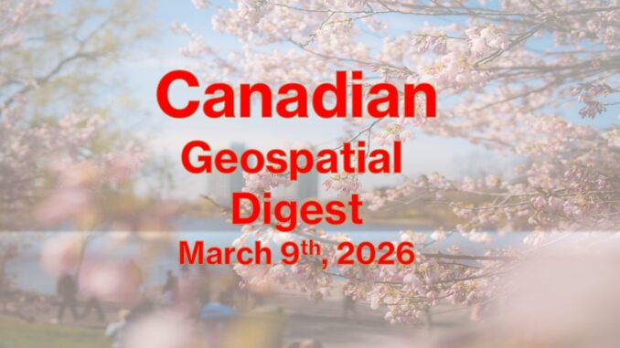
Medicine Hat drone company gets $1.1M federal loan for weather and combat testing
A Medicine Hat company, Landing Zones Canada, is receiving a $1.1-million loan from Prairies Economic Development Canada. Their main product is an artificial intelligence drone that aims to replace traditional weather balloons in hopes to protect Canadian airspace.
“The drones developed by Landing Zones Canada ride a balloon thousands of metres into the air, gather data and then fly to a designated location using AI — and can be used hundreds of times.” The drones are already being tested for the Advanced Arctic Over-the-Horizon Radar project, according to Fraser. Read more here.
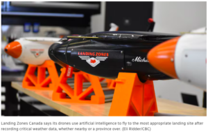
NWT publishes new flood maps for five communities
The Government of the Northwest Territories (GNWT) has recently updated their flood hazard and inundation maps for high risk communities. The last time these maps were updated was in the 1980’s, which was a much needed update. The new maps are now available here for the Aklavik, Fort Simpson, Hay River, Kátł’odeeche First Nation and Nahanni Butte communities.
As Canada heads into rapidly changing environmental conditions, regular updates for flood risk mapping are going to be needed more frequently, which draws on the demand for more geospatial investment. Read more here.
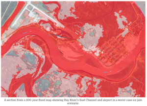
One data centre or one million homes? Mapping Ontario’s proposed hyperscaler boom
Communities in Toronto are being considered for a hyperscale data centre. This data center has a projected electricity demand of roughly two million homes. This leaves a heavy concern for residents over the strain electricity grids, raise rates, and consume large amounts of water.
The process requires a lot of geospatial analytics to find the most optimal area for the data centre. Additionally, land rights needs to be considered too and this decision should not be taken lightly from a geospatial perspective. Read more here.
N.S. resident builds crowdsourced pothole map to promote civic responsibility
Nova Scotia residents are increasingly frustrated over the lack of pothole repairs across the province. Residents have now used map crowdsourcing to identify the worst roads across the province as well as show residents how the government classifies potholes which then denotes how they’ll be repaired.
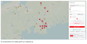
Additionally the website has a one click email feature that contacts the municipal, provincial, or federal representatives. The website is called RoadRot and looks like it has the potential to expand past N.S. Read more here and see the map here.
Canada’s space commander on protecting satellites from jamming and potential nuclear risks
Modern societies heavily rely on satellites for GPS, communications, and financial systems. This heavy reliance creates a concern over potential targeted Electromagnetic Pulse (EMP) attacks. These attacks have the potential to disrupt and collapse modern infrastructure long term. Satellite jamming is also being used at a warfare level.
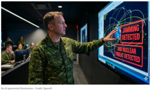
Canada is focusing on its resilience and investing into sovereign satellites while relying on international partnerships and diplomacy to uphold order in space and reduce the risk of satellite attacks. Read more here.
NordSpace founder backs Wyvern with new Canada-focused venture arm
NordSpace has invested into Wyvern, an Earth-observation company headquartered in Edmonton, Alberta, with a new initiative aimed at strengthening Canada’s sovereign space capabilities. The investment strategy focuses on developing satellite hardware for a hyperspectral imaging constellation that keeps the value local to Canada rather than outsourcing or launch vehicles.
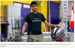
Wyvern is also expanding its Dragonette satellite constellation to make its data more accessible and easier for customers to use. Read more here.


Be the first to comment