- The prospect of space mining is growing more likely, and Canada may be a key player
- Black and grizzly bears might be detected by the same AI radar that detects polar bears
- Winter activities in Canada’s National Capital Region
- To bridge Canada’s digital gap, researchers use artificial intelligence (AI) to detect potential satellite problems proactively
- Geospatial technology is used in a collaborative study endeavour to find the locations of forgotten graves in Vulcan County
- Canada’s Google Maps will soon have comprehensive information on EV charging stations
1. The prospect of space mining is growing more likely, and Canada may be a key player.

Experts believe that space mining is becoming a reality and that Canada may be a major player in it. The Canadian Space Agency (CSA) and other space agencies are investigating space mining as a potential career path in light of the planned Artemis missions and the construction of the Lunar Gateway. The Canadian Space Agency (CSA) provides money for research to organizations such as Deltion Innovations Ltd. and the Canadian Space Mining Corporation. Within the next ten years, space mining is anticipated to concentrate on obtaining resources from the moon, such as oxygen and water. Read more in detail here.
2. Black and grizzly bears might be detected by the same AI radar that detects polar bears

An artificial intelligence radar technology that was first created to identify polar bears may be modified to detect black and grizzly bears as well, providing a means of improving human-bear cooperation. The “Bear-dar” radar device was created by Polar Bears International’s senior director of research and policy, Geoff York, and it makes use of military technology. It may be able to avoid unpleasant encounters by remotely detecting bears and sending notifications. Conservation officials may use the system, which is currently in its last test year, to monitor bear behavior in certain locations and receive remote notifications around the clock. Strobe lights and other similar deterrent devices could be installed on the radar towers. Read more about this here.
3. Winter activities in Canada’s National Capital Region
Experience winter sports including hiking, skiing, snowshoeing, and snow riding on over 450 km of repurposed trails and parks in the National Capital Region, Canada. There is a vast network of cross-country ski tracks in Gatineau Park, and there are also a variety of alternatives available on urban winter paths and natural trails in the Greenbelt. Take advantage of additional activities, including tobogganing, skating on the Rideau Canal Skateway, and viewing holiday light displays. For route information, use interactive maps. Learn about parking regulations, trail etiquette, and everything the Winter Capital has to offer. The winter experience is made possible by a number of community partners, and NCC trails outside of Gatineau Park are free to use. Read more here.
4. To bridge Canada’s digital gap, researchers use artificial intelligence (AI) to detect potential satellite problems proactively
In an effort to bridge the digital divide in Canada, researchers at the University of Waterloo and the National Research Council are using machine learning to spot possible satellite problems before they impede rural and isolated residents’ access to the internet. The team’s creation, the Multivariate Variance-based Genetic Ensemble Learning Method, combines a number of AI algorithms to identify abnormalities in networks and satellites and avoid connection problems. In testing using datasets from NASA’s Soil Moisture Active Passive, the Mars Science Laboratory rover, and a major internet provider, the technique surpassed existing models in terms of accuracy, precision, and recall. The goal of the research is to make satellite systems more resilient and dependable. Collect details here.
5. Geospatial technology is used in a collaborative study endeavour to find the locations of forgotten graves in Vulcan County

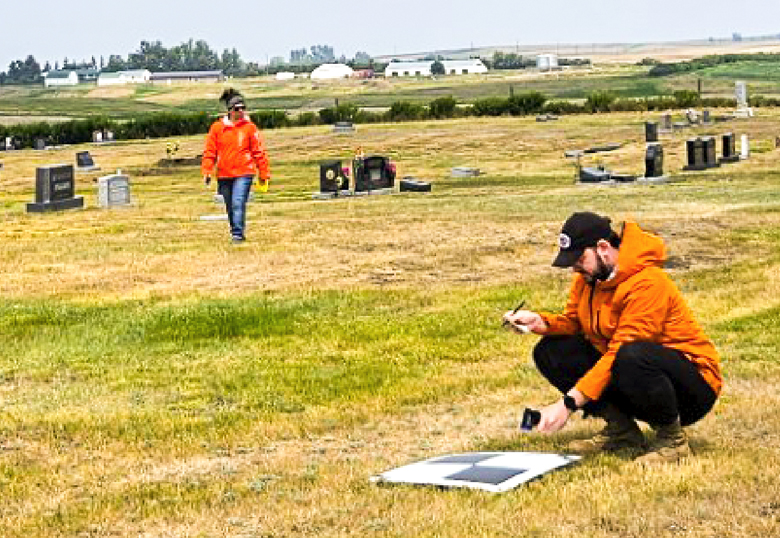
In a research project titled “Locating Missing Grave Sites using Remote Piloted Aircraft Systems,” the University of Lethbridge and Vulcan County work together to discover and record possibly lost cemetery sites using cutting-edge geospatial technologies. The program tackles issues that rural communities confront, such as the absence of proper records and monuments in many cemeteries, which makes maintenance difficult and puts ancient burials in danger during excavation. Dr. Craig Coburn leads the research team that uses a remote-piloted aircraft system equipped with thermal and multispectral imaging equipment to do non-destructive surveys, update city records, and save sacred sites from being disturbed in the future. Municipal stakeholders and Mitacs provide funding for the project. Find out more here.
6. Canada’s Google Maps will soon have comprehensive information on EV charging stations

Google Maps is being improved; one such feature is Immersive View for Routes, which uses AI and computer vision to give a thorough preview of the trip. The function is being rolled out around the world, including in Canada. 50 more cities are added to the Search with Live View, which is now called Lens in Maps. These cities include Montréal, Toronto, and Vancouver. In addition, twelve nations’ worth of maps—including Canada—will have improved highway navigation, accurate architectural renderings, and updated colours. This week, Google Maps for iOS and Android will begin rolling out in Canada with comprehensive information on EV charging stations for owners of electric vehicles. Read more in detail here.


Be the first to comment