
- UVic-led Ocean Networks Canada shares data from first all-Canadian Antarctic expedition
- ‘GATS-mobile’ mapping car captures real-time inventory of Ottawa streets
- Metaspectral reveals AI-powered analysis of hyperspectral imagery
- National Elevation Data Strategy updates databases
- NordSpace explores new ground stations across Canada with C-CORE
- Canada Structures releases open-source databases
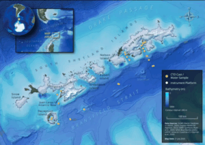
UVic-led Ocean Networks Canada shares data from first all-Canadian Antarctic expedition
The University of Victoria, Ocean Networks Canada (ONC), and Royal Canadian Navy teamed up for The Canadian Antarctic Research Expedition (CARE 2025), conducting research on the impacts of climate at locations that are experiencing rapid change.
The expedition was the first all-Canadian-led scientific team to the Antarctic. From a geospatial perspective, the research incorporated oceanography, geoscience, and cartography to help represent the findings. Read more about the expedition here and view the public data from the portals here and here.
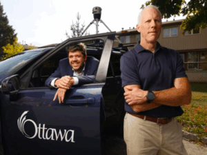
‘GATS-mobile’ mapping car captures real-time inventory of Ottawa streets
The City of Ottawa has pushed a new data collection method with the Geospatial Analytics, Technology and Solutions branch, also referred to as GATS-mobile. The purpose is to capture “real-time data of Ottawa streets and build a digital inventory of street signs, traffic signals, pavement markings, streetlights, and pedestrian crossings”.
The camera itself is known as Mosaic X, which includes a 360-degree view and LiDAR. This method is similar to Google’s but was developed in-house, showcasing the effective bridge that geospatial technology is creating for smaller industries to assist with larger projects. Read more about GATS-mobile here.
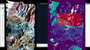
Metaspectral reveals AI-powered analysis of hyperspectral imagery
Metaspectral has developed a new remote sensing tool using AI machine learning to help speed up the process of identifying features through the Hyperspectral and Metaspectral lens. The tool is called Clarity AI and uses “machine learning techniques and custom FPGA hardware to shrink [large image files] from 60% to 90%, depending on the amount of acceptable lossiness in the imagery.
Overall, the tool aims to reduce storage pressure and speed up the process of analyzing hyperspectral imagery, particularly the bands invisible to the human eye, while eliminating human error and analysis from the equation. Read more about this tool here.
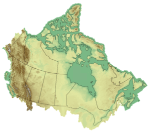
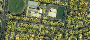
National Elevation Data Strategy updates databases
The National Elevation Data Strategy has recently updated its database as of September 2025. The database showcases high-resolution imagery of Canadian populated areas using lidar and satellite imagery. The technology has become so accurate that individual buildings, bridges, and even trees can be picked up. All of this data is public and can be viewed here.
NordSpace explores new ground stations across Canada with C-CORE
NordSpace and C-CORE are working together to develop new ground stations across Canada. The two companies have signed a Memorandum of Understanding (MOU), and plan to make stations in St. Lawrence, Newfoundland and Labrador, and Inuvik, Northwest Territories.
The companies released a statement on their goals being that “This collaboration is focused on supporting communications, telemetry, tracking, and control for satellites, launch vehicles, hypersonic flight vehicles, and other space and aerial systems critical to Canada’s strategic and commercial aerospace future.” Read more here.

Canada Structures releases open-source databases
Canada Structures, part of the Public Safety Canada, has released open source databases on Open Data Base of Buildings (ODB), Open Street Maps (OSM) buildings, and Microsoft Building Footprints (MSB) for every province and territory. This is an amazing data source and deserves to be shared amongst the Canadian geospatial community. Find the file directory here.


Be the first to comment