
If you work with geospatial data in Canada, you have likely heard the phrase “CSRS modernization” more often over the past few years. Sometimes it comes up in discussions about reference frames, sometimes in relation to GNSS, and sometimes alongside unfamiliar acronyms like NATRF2022 or new geoid models. For many people, it is clear that something is changing, but much less clear what that change actually means for their work.
This uncertainty is understandable. Reference systems tend to operate quietly in the background, and when they are discussed, the explanations often become technical very quickly. The result is that modernization can sound disruptive or intimidating, even when the goal is long-term stability and consistency.
CSRS modernization is not a single change, nor is it about replacing everything at once. It is a coordinated update to how positioning and heights are defined in Canada, reflecting how much our ability to measure the Earth has improved. In practical terms, modernization involves two closely related components: how positions are defined in space (the geometric reference frame) and how heights are defined relative to mean sea level (the vertical datum).
These two components do not behave in the same way. Some aspects of modernization will be more noticeable than others, depending on the type of data and workflows people are using. For many users, particularly those already working within more recent systems, the changes will feel incremental rather than dramatic. What matters most is understanding why these updates are happening and how to think about them, not memorizing technical details.
This article is the first in a short educational series designed to help orient readers to CSRS modernization. Instead of diving into specifications or implementation steps, the focus is on developing an intuitive understanding of what is changing, what is not, and why the modernization matters.
What does “modernization” actually mean in this context?
When people hear the word modernization, it often suggests replacement, an old system being discarded and a new one taking its place. In the context of CSRS, however, modernization is better understood as an adjustment to underlying assumptions rather than a reset of everything built on top of them.
Reference systems are designed to reflect how we understand the Earth at that time. As measurement capabilities improve, limitations in older definitions become increasingly apparent. The updates now being discussed are the outcome of this gradual process, rather than a sudden shift. Modernization is the process of updating reference system definitions so they remain compatible with the level of precision we are now able to achieve.
Importantly, the physical world is not static. The Earth is constantly moving, even if those changes are small and often go unnoticed in everyday experience. Roads, buildings, coastlines, and infrastructure do not suddenly shift from one day to the next. Modern measuring techniques such as GNSS, which are tied to the centre of the Earth, are now precise enough to detect these subtle motions. What changes is the mathematical framework used to describe position and height, so that it can accurately account for both how the Earth moves and how precisely we are able to measure it.
This is why CSRS modernization is described as system-wide rather than isolated to a single component. It involves updating how positions are defined in space and how heights are referenced relative to mean sea level, each responding to different aspects of how the Earth behaves and how we measure it. These updates are coordinated so that horizontal and vertical information remain consistent with one another, both nationally and across borders.
Modernization is not about introducing disruption, but about ensuring continuity. It allows reference systems to remain reliable as technologies evolve, reducing long-term inconsistencies and making it easier to integrate data collected at different times and across jurisdictions.
Two parts of the same system: positions and heights
At the heart of CSRS modernization is a distinction that is easy to overlook but essential to understanding what is changing: how positions are defined is not the same as how heights are defined.
In everyday geospatial work, these two are often bundled together. A coordinate is assumed to describe “where something is,” and a height is treated as just another number attached to that location. In reality, positions and heights are defined using different reference concepts, respond to different physical processes, and are modernized for different reasons.
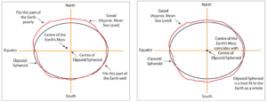
The geometric reference system describes how positions are defined in three-dimensional space relative to the Earth’s centre. It provides the foundation for latitude, longitude, and ellipsoidal height, and underpins GNSS-based positioning. As measurement technologies have improved, especially with satellite-based systems, it has become increasingly important that this geometric framework accurately reflects how the Earth moves and how positions are measured globally
The vertical reference system (vertical datum), by contrast, is concerned with how heights are defined relative to mean sea level. It relies on the Earth’s gravity field rather than purely geometric relationships, which means it responds differently to physical changes and improvements in measurement. Heights are particularly important for applications such as engineering, water management, and environmental monitoring, where even small inconsistencies can have real-world consequences.
Although these two components serve different purposes, they are not independent. Modernizing one without considering the other would introduce inconsistencies rather than resolve them. CSRS modernization therefore treats geometric positioning and vertical referencing as complementary parts of a single, coherent system, ensuring that position and height information remain aligned as both are refined.
Understanding this distinction helps explain why different aspects of modernization are experienced differently by users. Some changes are more noticeable in coordinate values, while others primarily affect height information. Recognizing that these differences are expected, and intentional, is an important step toward making sense of the modernization as a whole.
How differences show up in practice
Once the distinction between positions and heights is clear, the remaining question is how those differences actually show up when reference systems are modernized.
For geometric positioning, modernization addresses limitations that have become visible as GNSS measurements have grown more precise. Older systems were not fully Earth-centred and relied on plate motion models that are now known to introduce small but measurable errors over time. Updating the geometric reference system resolves these issues, which can result in noticeable shifts in coordinate values. These shifts do not indicate movement on the ground, but rather a more accurate alignment between coordinate definitions and the physical Earth they describe.
Vertical referencing evolves differently. Heights are tied to the Earth’s gravity field, and improvements in gravity modelling tend to refine height values rather than fundamentally redefine them. For many users, particularly those already working within more recent vertical datums, the resulting changes in height values are comparatively small. The primary benefit is not the magnitude of change, but the improvement in accuracy and consistency.
One of the most significant outcomes of these vertical refinements is improved consistency across national boundaries. By adopting a common approach to modelling the gravity field across North America, height information becomes compatible between Canada, the United States, and Mexico in a way that has not been possible for decades. For applications that cross jurisdictions, this consistency often matters more than the numerical differences themselves.
Modernization is less about abrupt change and more about alignment. Each update responds to a specific limitation exposed by modern measurement capabilities, ensuring that positions and heights remain coherent as technologies and datasets continue to evolve.
About this series
This article is intended to provide orientation and context, not to serve as technical guidance or implementation advice. CSRS modernization involves formal definitions, realizations, and tools that are documented and maintained through official channels. Those authoritative details are essential when it comes time to update workflows or systems, but they are beyond the scope of this discussion.
The purpose here is to help readers build a clear mental framework for understanding why modernization is happening and how its different components fit together. With that foundation in place, official documentation and technical resources become easier to interpret and apply when they are needed.
Subsequent articles in this series will continue to focus on building that understanding, starting with a closer look at why reference systems need to change as measurement technologies evolve. Readers looking for specifications, timelines, or implementation guidance are encouraged to consult official CGS resources, which provide the most up-to-date and well-founded information.


Be the first to comment