In his paper, published in the journal Transportation Planning and Technology, Jose Arturo Jasso Chavez delves into the accessibility of Montreal’s green and gray urban nature. In an interview with Emma Chothani, one of GoGeomatics Volunteer Editors and Group Writers, he opens up about his research findings and future goals as he pursues his PhD in Geography at McGill University under Professor Kevin Manaugh.
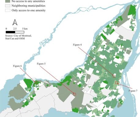
Inspired by methodology of previous studies, Jasso Chavez defines green urban nature as any park or green spaces and gray urban nature as urban amenities that foster sustainable development. For simplification purposes, Jasso Chavez includes food stores and pharmacies as a proxy for gray urban nature. He sets a 15 minute walking limit as the accessibility measurement to each amenity. This is based on the idea of the 15 minute city in urban planning, which postulates that cities be designed so that everything a person needs can be found within a 15 minute walk, bike, or transit. Jasso Chavez explains, “We used time instead of distance as it better captures real-world conditions. Time can fluctuate significantly based on transportation modes and city conditions, such as intersections, traffic lights, or transit schedules.” While he chooses walking for this paper, he recognizes that residents in some neighborhoods may predominantly travel by cars or public transit. Therefore, he plans to set neighborhood thresholds in future research, which might vary in time and transportation mode.
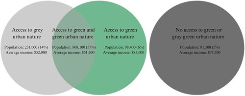
Jasso Chavez et al.’s results show that Montreal is relatively accessible to both green and gray urban nature with only 5% of residents having no access to either amenity. He also found that 65% of low-income residents have access to both green and gray urban nature, which contrasts high-income neighborhoods that only have 52% access. Access distributed by population and average income can be seen in the figure below. Jasso Chavez cautions against accepting this as reality: “having access doesn’t mean everyone can participate in society.” He explains that using these resources costs time and money, which is sometimes not available to low-income populations.

As he continues his research in his PhD, Jasso Chavez hopes to answer the questions “How much is enough? How much do we need?” This theory of distributive justice incorporates a sufficientarianism approach, which he states “goes beyond relative distribution and focuses on absolute distribution.” In the past, egalitarianism has been used, founded on the principle that by reducing inequalities, justice can be achieved. A sufficientarianism perspective challenges this notion and states that everyone should have enough. Using thresholds Jasso Chavez et al. establish, it seems that Montreal’s population has enough access to green and gray urban nature. However, future research should focus on whether these thresholds are enough for adequate participation and quality of life. Jasso Chavez says “we need to ask people if it’s enough.” If it’s not enough, it is important that future research measures what people need based on what they value.
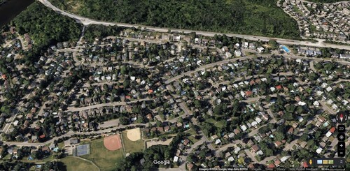
Looking at the disparities between income groups with a sufficientarianism perspective, Jasso Chavez explains “High income groups tend to live in the suburbs where they have access only to green areas.” A Google Maps example of this can be seen in the figure below. Since people choose where they live, maybe they don’t care if they have access to gray urban nature because they have cars. According to the sufficientarianism perspective, it is fair for them to lack gray urban nature since they chose to live in a location with low levels of accessibility. This framework can then lead to externalities, which affect all residents like increased traffic and pollution from motor vehicle use in these low-accessibility suburbs.

Ultimately, Jasso Chavez knows that every population has different needs and values, so minimum accessibility thresholds are context dependent. He says, “What is important is to find an equilibrium…How can we capture everyone’s needs and… how can we make this accessible for policymakers.” Jasso Chavez hopes to go deeper with his PhD, including exploring several transportation modes, a variety of amenities, and neighborhood accessibility thresholds in his analysis. Most importantly he hopes to incorporate what people value and what they consider is enough.
Discover more by reading his full paper here: https://www.tandfonline.com/doi/full/10.1080/03081060.2024.2399635?src=exp-oa#abstract


Be the first to comment