
Canada currently lacks a sovereign Global Navigation Satellite System (GNSS) and several core components of modern geodetic infrastructure needed to ensure reliable positioning, navigation, and timing (PNT). Canada now depends heavily on foreign satellite systems that are designed, governed, and prioritized by other states. With geopolitical tension high right now, GNSS is increasingly treated as a strategic national infrastructure. This reliance places Canada at risk and makes it an outlier among the other G7 nations, many of whom invest heavily in maintaining independent PNT capabilities.
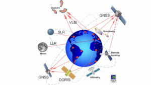
Geodesy underpins virtually all PNT activities by measuring the Earth’s shape and tracking how it changes over time. Geodetic infrastructure supports critical communications and monitoring functions across sectors such as telecommunications, transportation, and environmental science. Demand for precise, real-time geodetic data is growing across both public and private sectors. Canada still has a minimal presence in global geodetic observatory networks, such as Very Long Baseline Interferometry (VLBI) and Satellite Laser Ranging (SLR), which are essential for maintaining accurate satellite orbits and national reference frames. This gap limits Canada’s ability to independently verify satellite data, maintain positioning accuracy, and support critical activities including Earth observation, defence, and industries that rely on precise positioning and timing.
Canada’s limited access to secure GNSS services further illustrates this vulnerability. Despite its long-standing ties with the European Space Agency, Canada does not have access to Galileo’s Public Regulated Service (PRS), the encrypted signal reserved for government and military use. Like other non-EU countries, it is restricted to Galileo’s open civilian signals. The United Kingdom’s loss of PRS access after Brexit, despite having helped build Galileo, demonstrates how quickly geopolitical changes can disrupt access to critical space-based infrastructure. This example highlights how access to secure GNSS services is ultimately governed by political and strategic considerations, not technical capability or historical partnership alone.

Global navigation satellite systems such as GPS rely on geodetic reference frames maintained through international cooperation.
In response to these challenges, the Council of Canadian Academies (CCA), at the request of Natural Resources Canada (NRCan), has launched an assessment examining how geodetic infrastructure affects Canada and its economy. The study will evaluate the opportunities associated with renewed domestic investment, the risks of diminished access to high-quality geodetic information, and whether Canada’s current infrastructure is sufficient to support activities that depend on precise positioning and timing. An expert panel will be appointed, with the final report expected in late 2026. This marks an important step toward formally integrating geodesy and PNT into Canadian economic planning and long-term national infrastructure strategy.


Be the first to comment