
Canada’s infrastructure conversation is changing.
Industrial policy is tightening. Procurement modernization is accelerating. Canadian security independence and defence capability are receiving renewed attention. Supply chain resilience and trusted digital systems are now operational priorities.
Within that shift, geospatial capability is moving closer to the centre of national infrastructure planning.
Space and Earth observation underpin environmental monitoring, Arctic awareness, and resource management. Geospatial intelligence informs security and operational readiness. Digital delivery systems shape how transportation, energy, housing, and public works are designed and managed. Standards and interoperability determine whether systems function coherently across jurisdictions. Artificial intelligence is accelerating modelling and decision support across all of these domains.
This is where the concept of sovereign geospatial infrastructure becomes practical rather than rhetorical.
Sovereignty in this context does not imply isolation. It implies resilient systems, trusted standards, domestic capacity, and clear governance frameworks. It means building infrastructure that Canada can depend on while maintaining strong partnerships with allies and international firms that operate within transparent, standards-based environments.
GeoIgnite 2026 has been structured in direct response to this environment.
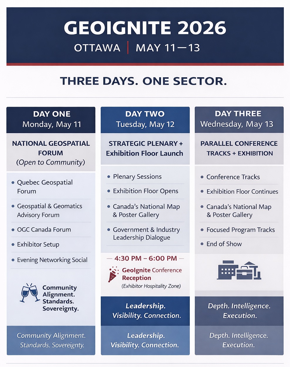
The conference opens with a National Geospatial Forum focused on sovereignty, workforce development, procurement, standards, and interoperability. The plenary program examines geopolitics, resilience, and the acceleration of technology within national systems. The final day moves into focused tracks on geospatial intelligence and Arctic sovereignty, space and Earth observation for national resilience, and digital delivery with an emphasis on sovereign data capability.
The architecture aligns with where the country is moving.
As Canada strengthens domestic capacity and refines procurement models, the geospatial sector becomes increasingly tied to long-term infrastructure planning. Public institutions depend on industry for technical capability, systems integration, and implementation capacity. Industry depends on clarity in standards, procurement direction, and long-term policy signals. Alignment between the two is essential.
GeoIgnite exists to facilitate that alignment.
For exhibitors and sponsors, this year carries particular significance. Participation is not simply about brand visibility. It is about positioning within a national capability conversation that is gaining structural importance. Organizations operating in data infrastructure, Earth observation, digital twins, AI-enabled analytics, standards development, secure systems, and public sector delivery will find that the themes shaping federal and provincial decision making are converging inside this forum.
Sponsorship and booth placements are active, with pricing adjustments scheduled after March 15, 2026, consistent with the published commercial structure. As the program continues to solidify, the exhibition floor and leadership conversations will increasingly reflect the organizations that choose to engage early.
For full sponsorship and exhibition details:
Confirmed Sponsors and Partners
GeoIgnite 2026 is already supported by Gold Sponsor NV5 Geospatial; Silver Sponsors Pacific Geomatics, K2 Geospatial, and PACGEO; Bronze Sponsor Esri Canada;
and program partner the Open Geospatial Consortium through the OGC Canada Forum.


Be the first to comment