
As we welcome 2026, the GoGeomatics volunteer and editorial team is reflecting on 2025, a year of remarkable global progress in geospatial science and technology. To close out the year, we’re sharing our pick for the most impactful international geospatial story of 2025—one that stood out for its innovation, global relevance, and lasting impact.
- Benedicta Antwi Boasiako: Gaza war in maps and satellite images
- David Legris: U.S. braces for uncertainty ahead of peak hurricane season amid NOAA upheaval
- George Petropoulos : Inside the launch of FireSat, a system to find wildfires earlier
- Jonathan Murphy: AI as a Transformative Geospatial Technology
- Anusuya Datta: The European Space Agency secured a historic budget increase and a clear defence and security mandate at its ministerial council
- Alefiya SJ: Cross-Modal Reasoning at Planetary Scale: The Rise of Google Earth AI
Benedicta
Gaza war in maps and satellite images
BBC provides an interactive visual resource showing maps and satellite imagery of the Gaza conflict, offering geographic context to changes on the ground, territorial control, and humanitarian impacts amid ongoing hostilities and ceasefire negotiations
Why its important?
The Gaza maps and satellite analysis stood out this year because it showed the public, in a very clear way, how geospatial tools help us understand a crisis that is otherwise hard to grasp. The story combined change detection, population displacement data, damage mapping, and time series imagery to trace how the conflict reshaped Gaza’s landscape over two years. It demonstrated how satellite data can cut through uncertainty and give the world a factual picture of what is happening on the ground when access is limited and conditions are constantly shifting.
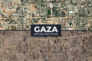
It also highlighted how Earth observation supports humanitarian work, from tracking destroyed neighbourhoods to mapping no-go zones and the movement of people. For many readers, this was one of the first times they had seen spatial analysis used at this scale to explain human impact. As a result, it became a powerful reminder of why geospatial science matters. More articles from Benedicta
David Legris
U.S. braces for uncertainty ahead of peak hurricane season amid NOAA upheaval
NOAA has faced significant staffing cuts affecting weather forecasting capacity, raising concerns about preparedness as the 2025 Atlantic hurricane season approaches. Despite reduced personnel, the agency continues hurricane outlooks to guide readiness for potentially active storm activity
Why its important?
Earlier this year, the Trump Administration stated their intention of shrinking the National Oceanic and Atmospheric Administration, also known as NOAA. During the summer, the impact of staff cuts were felt as the roughly 3000 organization-wide vacancies impacted NOAA’s ability to respond during a heavy hurricane season. Reductions in NOAA’s budget and staffing have diminished the organization’s ability to collect data, forecast weather and design accurate modelling. While the Trump Administration has indicated a willingness to rehire a portion of eliminated staff, the damage to NOAA may be long-lasting.
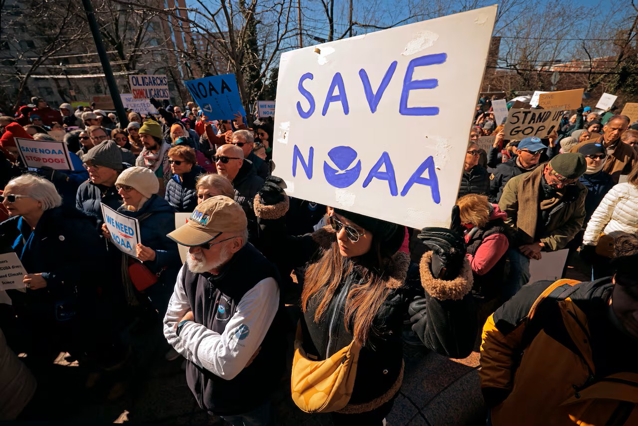
This story is important, as it highlights potential impacts of the institutional anti-science streak in the United States, which can be seen in the actions of other institutions such as NASA, the US Military, and Congress. Data collected by large and prestigious institutions such as NOAA and NASA are massively important for global scientific research and the geospatial industry. If research and data collection continue to be diminished, or are entirely eliminated from these institutions, it will likely have a global reach. More articles from David
George Petropoulos
Why it’s important?
The first satellite constellation focusing on early wildfire detection and mitigation spearheaded by google and satellite manufacturer Muon Space. The Google Research division and Muon Space are among the founding partners in Earth Fire Alliance, the nonprofit home for FireSat. FireSat expands on the wildfire response work that was first launched in 2020 which uses AI and satellite imagery to create a wildfire boundary map.
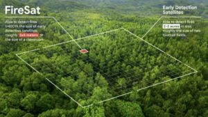
This allows for quick access to see the approximate size and location of wildfires in their area through google services, while also notifying nearby communities with information on how to stay safe. Not only does this help first responders, but will also supply historical data for research purposes to better model and understand wildfire behaviour. More articles from George
Jonathan Murphy Publisher of GoGeomatics Canada
AI as a Transformative Geospatial Technology
In 2025, artificial intelligence became the most transformative force shaping the geospatial sector. Much like the invention of GIS embedded spatial thinking into decision-making, AI is now redefining how geospatial data is processed, interpreted, and acted upon at scale. This shift is not experimental; it is foundational.
The broader significance of this transition was reflected when Time magazine named the “Architects of AI” as its 2025 Person of the Year, underscoring AI’s role as a defining technology across industries and societies. The full article can be found here
Anusuya Datta
European Space Agency member states have agreed to a €22.1 billion budget for the next three years, marking a roughly 30 % increase and nearing ESA’s requested funding level. The boost supports space science, exploration, secure communications, and security programmes under its Strategy 2040 framework.
Why its important?
The European Space Agency’s expanded budget and defence mandate strengthen Europe’s Earth observation, navigation, and satellite intelligence capabilities. This directly benefits geospatial data availability, resilience, and innovation, supporting climate monitoring, disaster response, infrastructure planning, and security-focused mapping applications across Europe and globally. More articles from Anusuya

Alefiya SJ
Cross-Modal Reasoning at Planetary Scale: The Rise of Google Earth AI
Google Earth AI combines cutting‑edge foundation models with a Gemini‑powered geospatial reasoning agent to analyze imagery, environmental, and population data. It enables complex, real‑world geospatial insights at planetary scale, transforming Earth observation and decision‑making across global challenges.
Why its important?
Google Earth AI matters because it moves geospatial analysis from manual data mash-ups and bespoke models to an integrated, AI-driven platform that can:
1. Reason across imagery, demographics, and environmental models
2. Answer complex natural language queries
3. Provide actionable insights at planetary scale
4. Enable new workflows for both research and real-world applications
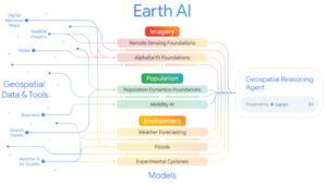
For the geospatial community, this is more than a new tool — it’s a framework that could change how we interact with and extract meaning from the world’s most complex datasets. More articles from Alefiya


Be the first to comment