
Access to satellite imagery remains as important as ever
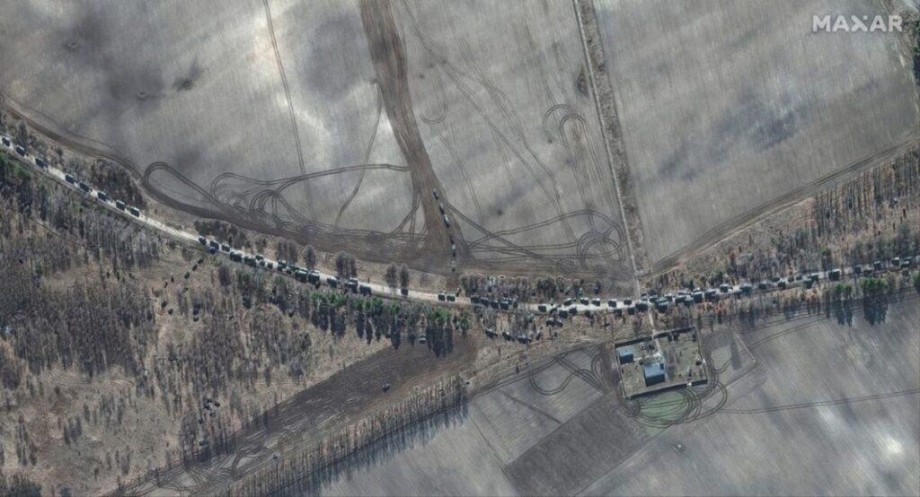
At the beginning of the Russia-Ukraine war, it became clear that satellite imagery provided critical intelligence to Ukraine from leading companies such as Maxar, BlackSky, and Planet, in the form of high-resolution imagery. Many of these images were part of the support provided by Western countries. The imagery from Maxar would come via the American government, and Canada supplied key SAR imagery via MDA’s Radarsat Constellation Mission.
However, a lot has changed in the geopolitical realm as the war has evolved, with elections and new administrations changing the outlook and approach of many nations that supported Ukraine at the beginning of the war. Most recently, a decision to cut back on intelligence sharing with Ukraine from the American administration appears to have had significant consequences, further highlighting the importance of this continued access to geospatial intelligence.
On March 6, “Ukrainian access to U.S. government-purchased commercial satellite imagery, which includes Maxar, was suspended, a National Geospatial-Intelligence Agency (NGA) spokesperson told ABC News.” This was due to the U.S. pause on intelligence sharing with Ukraine, and access to this intelligence allowed Ukraine to “give warnings to targeted areas ahead of Russian drone and missile strikes, tracking Russian aircraft taking off, drones being launched and missiles being fired.” Other officials warned that this reduction of shared intelligence could result in lost lives, as the information was a key tool that allowed Ukraine to defend itself against missile strikes.
Intelligence sharing resumed only days later, on March 11, as Ukraine agreed to terms seen as likely to lead to a 30-day ceasefire. The withheld intelligence coincided with bringing Ukraine to the table for ceasefire talks, spurred on by the American regime’s new position, highlighting just how important access to this information is to the continued defence of Ukrainian territory.
A spokesperson for the National Geospatial Intelligence Agency (NGA) confirmed on March 18 that Ukraine has regained access to the commercial satellite imagery platform that has been a crucial component of its intelligence-gathering capabilities since Russia’s full-scale invasion in 2022.
And while this brief intelligence blackout may have been enough to bring Ukraine back to the table, it highlights a much deeper problem in the Earth Observation community — the reliance on select industry leaders for information that is proving to be integral for proper defence coordination and planning.
It is safe to say that this has caught the attention of the global community.
Exploring new launches in response to changing geopolitical landscape
The timing of an important announcement from Andrius Kubilius, European Defense and Space Commissioner, cannot be a coincidence in the days following this key stoppage of intelligence sharing to Ukraine that “the European Commission is considering expanding its satellite capacities to improve geospatial intelligence support for security.” He talked about an effort to reduce dependence on external sources while signalling that they may take a “temporary commercial approach,” thought to be much like that of the U.S. with partners like Maxar and Planet.
The EU is already working on IRIS², seen as a Starlink competitor amid a rapidly changing geopolitical landscape, and centred on doubts of sustained support from the U.S. While IRIS² is more communications and internet-focused, talk of new intelligence satellites that would enhance defence coordination and crisis response is significant in giving EU nations independent access to critical intelligence. They certainly aren’t alone as many nations are considering alternatives given the policy shifts of the American administration of late.
Editor’s note
This underscores the critical need for countries to invest in sovereign satellite capabilities and Earth Observation systems to ensure security and self-reliance in the face of geopolitical uncertainties. For Canada, as a key player in global defense, climate monitoring, and natural resource management, this highlights the importance of strengthening its own geospatial infrastructure to secure national sovereignty. At GeoIgnite 2025, Canada’s premier geospatial leadership conference, discussions will focus on how geospatial intelligence can safeguard Canada’s interests, drive innovation, and build resilience amidst a rapidly evolving global landscape. The conference will also emphasize the importance of building a sovereign and self-reliant geospatial ecosystem to ensure Canada’s ability to thrive in an increasingly complex world. Join us in Ottawa for the discussions!


Be the first to comment