This article includes insights from Dr. Simon Banville, Senior Advisor for GNSS Products and Analysis at Natural Resources Canada and the technical lead behind this update.
Canada’s Precise Point Positioning (PPP) tool has just undergone a quiet but powerful transformation. The Canadian Geodetic Survey (CGS) has added Galileo, Europe’s satellite navigation system, to its PPP processing, bringing faster convergence and better accuracy to users across the country. For professionals working in the geodetic field, this means more dependable positioning from fewer observations, even in some of the most remote regions.
PPP is a service many in the geomatics community already rely on. Whether it’s for post-processing GNSS survey data or monitoring infrastructure, the CSRS-PPP service turns raw satellite observations into precise coordinates, anchored to the Canadian Spatial Reference System. With Galileo added to the mix, that process becomes faster and more robust.
“Users working with less than one hour of data can see a 40 to 60 percent gain in accuracy just from having Galileo available,” said Dr. Simon Banville, Senior Advisor for GNSS Products and Analysis at CGS.
- If you’re interested in the full breakdown of this update, including background documents, and processing models, have a read here: CSRS- PPP Updates and Information
What Galileo Brings to the Table
The real strength of this update lies in how it improves positioning geometry. Galileo brings more satellites into the solution, which means better satellite configuration in the sky and more measurement redundancy. This leads to a measurable reduction in noise, improved ambiguity resolution, and quicker results.
“Ambiguity resolution is really where the time savings come in,” said Dr. Banville. “When more satellites are in view, especially with a second constellation like Galileo, that process becomes faster and more stable.”
This matters to surveyors collecting static data, and also to researchers, engineers, and scientists using GNSS data to support time-sensitive work. In practice, the improvements show up most in short sessions, those lasting under an hour, where every second counts.
Getting Here Took Time
While Galileo’s first satellite launched nearly two decades ago, integrating it into the Canadian system took years of work. It required careful evaluation, model development, and global coordination.
“The models had to mature. We needed to be sure that Galileo data was of the same quality as GPS,” Dr. Banville explained. “That was only possible recently, thanks to the IGS reprocessing campaign.”
Once CGS was confident in the data quality and had all the technical pieces in place, the final update came together within a few months.
Reference Frames and Practical Tools
Alongside the Galileo rollout, CGS also updated the PPP system to use the IGS20 reference frame by default. This keeps the tool aligned with the latest standards from the International GNSS Service. To help users continue working with national reference systems, the PPP tool now automatically converts those results into NAD83 (CSRS) v8.
This kind of behind-the-scenes attention matters. Many users in Canada operate in regulated environments where national standards are non-negotiable. CGS ensured that the system update didn’t interrupt workflows or data integration.
What About Rapid and Final Products?
CSRS-PPP currently provides both Rapid and Final products, now with Galileo support. Rapid products are available roughly 17 to 18 hours after data collection ends. Final products take around two weeks. The difference in accuracy between the two is small, usually at the millimetre level, but for some users, every detail matters.
“Rapid is good enough for most applications,” Dr. Banville said. “Final is just slightly better because it includes more data and more contributing analysis centres.”
There are also plans to extend Galileo to Ultra-Rapid products, which are produced hourly and support near-real-time applications. That work is ongoing.
“It’s on the roadmap, but it’s a tough one,” Dr. Banville admitted. “We don’t yet have a way to combine Galileo data from multiple centers at that speed. The IT resources and automation required are on a different scale.”
Future Directions and Ongoing Needs
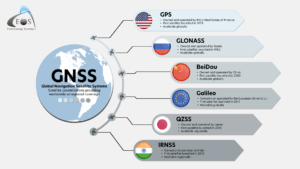
The Galileo integration is one part of a wider modernization effort by the Canadian Geodetic Survey. Plans are already in motion to expand the service by incorporating other constellations like China’s BeiDou and to explore the role of Low Earth Orbit (LEO) satellite systems in precise positioning.
But even as these technologies evolve, one of the biggest gaps isn’t technical. It’s human.
“There’s a real gap in the workforce. We need more people who can bridge geomatics and programming,” Dr. Banville shared. “Our work is scientific, but it’s also operational. And that’s a rare combination to find.”
This echoes broader concerns across the geodetic community. In this article, Reference Systems in Transition, exploring the future of reference systems, questions were raised about the sustainability of the field. Staffing shortages, limited institutional capacity, and the pressure to modernize are pushing the system to its limits.
The Galileo update shows what’s possible when the right expertise and dedication come together. But to keep moving forward, the community will need more people with cross-cutting skills, fresh ideas, and a willingness to take on both scientific and applied work.
For researchers, professionals and students this is a signal, geodesy needs you.
What It Means for Canada’s Positioning Ecosystem
The updated CSRS-PPP service brings improvements in accuracy and workflow efficiency. It keeps Canada’s geodetic system aligned with global standards. The addition of Galileo makes the service more responsive to field needs, from boundary surveys in remote areas to infrastructure monitoring and scientific studies.
More importantly, it reflects a national commitment to ensuring accurate positioning remains accessible to all Canadians, regardless of location. The CSRS-PPP update, shaped with care and led by expertise, is a meaningful step forward.


Be the first to comment