
When conducting Lidar surveys, efficiency and success are determined to a degree by conditions outside of the surveyors’ control. The best-laid plans can sometimes be delayed by inclement weather conditions, as wind, rain and fog can prevent aircraft from collecting accurate data or even from flying safely. The challenge is magnified for topobathymetric Lidar, which must be collected at specific times of year to ensure clarity of both water and coastline. Ambitious geospatial surveys leave little margin for error, putting surveyors up against the limits of time and Mother Nature.
A successful topobathymetric Lidar survey requires detailed planning and agile operations to ensure that survey crews take advantage of every suitable day for data acquisition. Until recently, project managers would plan surveys manually, providing updates to clients through regular email alerts. These processes are time-intensive, requiring managers to wake up early and spend valuable time focusing on communication rather than performance.
NV5 Geospatial’s INSITE Lifecycle Project Tracker Tool
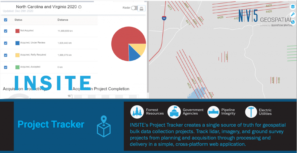
The INSITE Lifecycle Project Tracker Tool from NV5 Geospatial is a scalable, agnostic platform for project tracking and quality assurance. The cloud-based platform simplifies and automates the collection, storage and communication of geospatial data, providing a complete accounting of progress from data acquisition to processing and analysis. Data is updated daily throughout the system, providing customers with an up-to-date picture of the state of the project and dramatically reducing the amount of time spent by project managers on communication.
INSITE combines robust data management tools with elegant display capabilities. The platform supports simultaneous tracking for an unlimited number of projects and data formats, while data analytics tools keep stakeholders informed with continuously updated statistics and status maps. The INSITE Project Tracker also offers integration with Windy, a map forecast API that enables users to overlay weather elements on existing flight lines.
INSITE can be customized to the parameters of individual projects, providing a tailored suite of tools for tracking, quality control and data delivery. Customers can review and flag issues through the platform, reducing communications bottlenecks and leading to prompt responses and resolutions. INSITE uses open-source GIS technology to consolidate all project information into a single user-friendly mapping web application, enabling the survey crew and customer to quickly evaluate both the quantity and quality of collected data.

Proven in one of Canada’s largest topobathymetric Lidar surveys
The INSITE Project Tracker has been successfully used by customers throughout North America, ranging from private clients to federal, state and local government projects. For example, the platform was deployed in Lidar projects with GeoBC in British Columbia and Elexicon Energy in Ontario, in addition to complex government projects with the Commonwealth of Massachusetts and the National Oceanic and Atmospheric Administration.
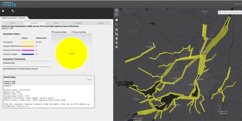
In September 2020, the Communauté Métropolitaine de Montréal (CMM) awarded a competitive tender to NV5 Geospatial to conduct an airborne topobathymetric Lidar survey of the principal watercourses surrounding the city of Montréal. Consisting of 28 watercourses and more than 900 kilometers of linear shoreline, the project was one of the largest of its kind to be undertaken in Canada.
Given the scope of the project and the area’s local weather patterns—with the sudden onset of fall and an average of 10 rainy days per month—NV5 Geospatial needed to take advantage of every suitable day to collect data and ensure on-time completion of the assignment. Both NV5 Geospatial and the CMM understood the importance of clear communication to the success of the project; the CMM expected to be able to monitor the progress of the acquisition from start to finish.
“Due to the size of the area being covered during the topobathymetric Lidar survey, we needed a partner we could trust to complete the project efficiently. There is little margin for error when trying to collect so much data during autumn in Montréal,” said Guillaume Spain, Project Manager at the Communauté Métropolitaine de Montréal. “NV5 Geospatial’s INSITE platform gave us confidence that the data was being collected efficiently and professionally. We were able to log in on a daily basis and evaluate the work which was conducted on the previous day, and we understood that NV5 was making the most of every possible opportunity to fly their aircraft.”

Proactive project management
The efficiency of the INSITE tool allows surveys to be conducted using proactive management practices; by eliminating uncertainty and reducing the stress surrounding communication, project stakeholders can focus instead on the efficiency of their operations and the quality of data being collected. The real-time communication platform is particularly valuable when things don’t go to plan or when sudden changes require a shift in strategy: rather than worrying about whether or not the team has communicated with the client, project managers can focus all of their attention on ensuring that the data is being collected effectively.
Advancements in geospatial technology and data processing are empowering government agencies and private companies to take on more and more ambitious survey projects. NV5 Geospatial’s INSITE Project Management Tracker is essential for the next generation of topobathymetric Lidar surveys, allowing survey crews to focus on collecting and processing exceptional data deliverables.
About NV5 Geospatial
NV5 Geospatial, powered by Quantum Spatial, is North America’s largest provider of geospatial services, providing end-to-end solutions and insights to organizations that need geospatial intelligence to mitigate risk, plan for growth, better manage resources and advance scientific understanding. We combine the widest array of advanced remote sensing technologies with proprietary processes, analytics tools, algorithms, and analysis tailored to meet our clients’ needs. For more information visit quantumspatial.com, join us on LinkedIn or follow us on Twitter @nv5geospatial.


Be the first to comment