
The GoGeomatics team brings to you interesting stories and content related to geospatial technologies, space missions, innovative use of maps, government and business decisions around location technologies within Canada and also around the world. This week we bring to you stories of International importance. We appreciate feedback on the stories and what more you would like to see.
SPACE GAME Changer from Amazon Web Services

Amazon Web Services is keeping its sights on the space sector. The cloud computing giant provides ground infrastructure for companies to process and analyze data from satellites, and is now looking to attract new customers by offering more customized services such as cloud-based satellite operations and mission control. “AWS is moving into space in a very big way,” said Clinton Crosier, director of aerospace and satellite solutions at Amazon Web Services. Learn more at https://spacenews.com/amazon-web-services-sees-role-as-technology-enabler-for-space-industry/
UAE the first Arab nation in history to have a scientific presence at Earth’s near neighbour
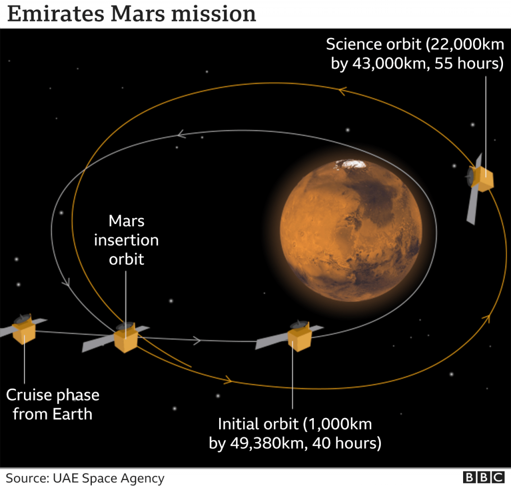
The United Arab Emirates’ Hope mission has returned its first picture of Mars. The spacecraft entered into an orbit around the Red Planet on Tuesday, making the UAE the first Arab nation in history to have a scientific presence at Earth’s near neighbour. Hope was put in a wide orbit so it could study the planet’s weather and climate systems, which means it also will see the planet’s full disk. Chair of the UAE Space Agency and the Emirati Minister of State for Advanced Sciences Sarah Al-Amiri said the country is “comfortably waiting, anxiously anticipating our entry into space exploration as a nation.” Another interesting thing to note is, that women make up 80% of the project’s scientific team. Read more about the mission here.
Visualization uses data from the World Bank to examine the countries with the highest shares of old and young people
Visual Capitalist is one of the fastest growing online publishers globally, focused on topics including markets, technology, energy and the global economy. Founded in 2011 in Vancouver, the team at Visual Capitalist believes that art, data, and storytelling can be combined in a manner that makes complex issues and processes more digestible. Recently they came up with an amazing visualization that shows dominant age groups in various countries. This visualization uses data from the World Bank to examine the countries with the highest shares of old and young people. Read more about the article here. The Top 10 countries in the world with the highest share of young people are all in Africa while the Top 10 countries with large shares of 65+ are mostly European nations. Japan has people over 65 make up more than a quarter of the population.
India opens access to its geospatial data and services, including maps
India’s Department of Science and Technology (DST), on Monday, opened access to its geospatial data and services, including maps, for all Indian entities by saying, “what is readily available globally does not need to be regulated.” The move is said to release a lot of data that is currently restricted and not available for free. The update represents a major change in the country’s mapping policy, which earlier required individuals and companies to seek approval for use of mapping data under the Geospatial Information Regulation Act, 2016. The Indian Space Research Organization (ISRO) and MapmyIndia announced a partnership, offer India’s best, and completely indigenous, mapping portals, apps and geospatial software. Official LinkedIn post by CEO and Executive Director, MapmyIndia. https://www.linkedin.com/pulse/announcing-path-breaking-aatmanirbhar-bharat-milestone-rohan-verma/
Cyprus develops new approaches for the detection of buried remains using EO
Archaeologists have discovered many relics of our ancestors across the Earth’s surface, but much more remains buried beneath the soil. Archaeological prospection plays an important role in both the identification of these special sites and their protection. Dr Athos Agapiou of the Cyprus University of Technology, at the Department of Civil Engineering and Geomatics and the Eratosthenes Research Centre, develops new approaches for the detection of buried remains. By using images and data collected from satellites, researchers can identify the archaeological proxies that indicate where buried archaeological sites remain as-yet undiscovered. Earth Observation data continues to play a greater role in research and could provide archaeologists with an important tool for cultural management. Read more about the research here
Mapping LOVE on Campus
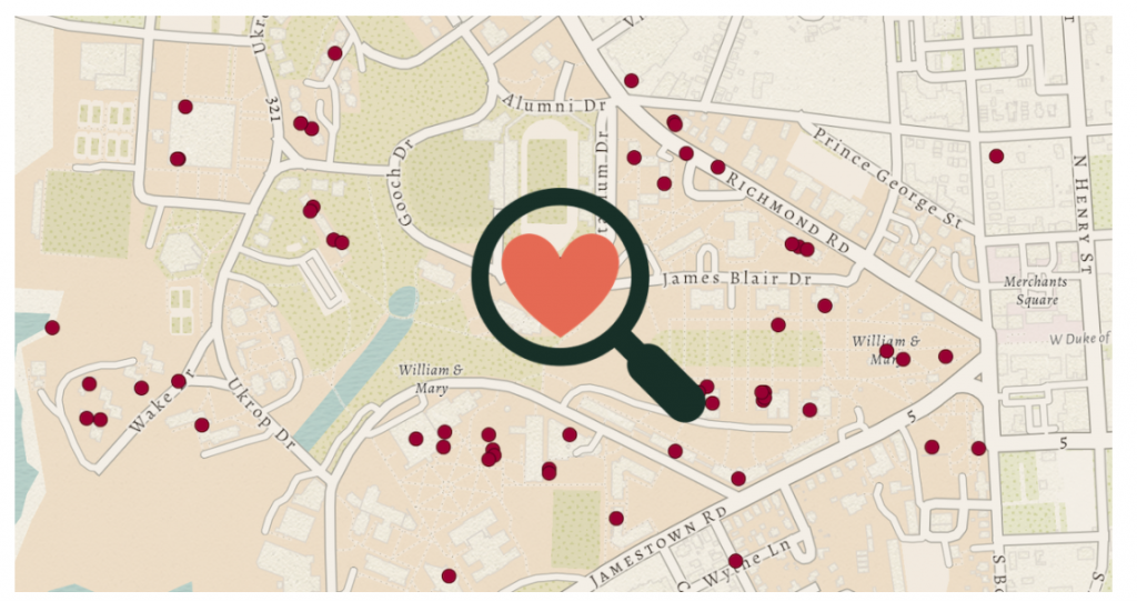
As students, Kira Holmes ’17 and Colleen Truskey ’17 heard a rumor that 25% of William & Mary students end up marrying someone else from the university. Later, as post-baccalaureate fellows at William & Mary’s Center for Geospatial Analysis (CGA), they wondered: Where are all these people meeting each other and falling in love? Can we crowdsource data to learn more about this? And could this project help W&M students learn more about geospatial analysis? The result was the “Where W&M Couples Meet” map, where students and alumni can plot where, when and how they met their significant other. (You can add your love story to the map using this online form.) The map launched for Valentine’s Day 2018.


Be the first to comment