Lidar Leads to New Discoveries at Ancient Mexican City
There have been many discoveries made over the last few years aided by emerging technologies used in archaeology. We can now add an extraordinary discovery at Teotihuacan, Mexico to the list. The team was attempting to determine how the ancient city was laid out compared to its modern counterpart. Included in their discoveries is that the builders of the ancient city bent the nearby San Juan and San Lorenzo rivers to match the cities’ astronomical alignment. Only about 30 miles northeast of Mexico City, the researchers were also interested in how the modern cityscape has impacted the famous ancient site. The researchers also found some disturbing news, stating that “205 features from the ancient city have been destroyed by mining operations since 2015”. To find out more about the important discoveries made at Teotihuacan, check out the full article here.
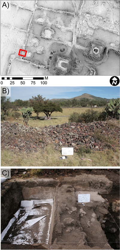
Image: Published under a CC BY license, with permission from N. Sugiyama, original copyright Project Plaza of the Columns Complex 2021.
New Methods for Detecting Ancient Cities without Digging
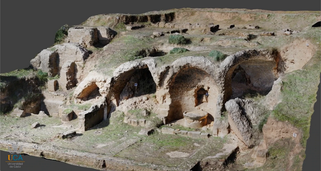
A team of Spanish researchers has discovered a new way of detecting ancient cities that have been buried underground over time without digging. The team is led by archaeologist Lazaro Lagostena, a professor at Cadiz University. Using what he calls “archaeology of the future”, Lagostena and his team have studied six ancient roman cities since 2016 using ground-penetrating radar, drones, and magnetometers to create images of the cities, all without digging. He says that he doesn’t know of another research team that has been able to study six Roman cities in such a short time. While the study of Roman cities has grabbed a wider audience, the methods employed by the team from Cadiz are more tried and true than one might think. They have over 60 projects completed to this point, working with a mix of public and private institutions, all since about 2003. To find out more about their amazing discoveries, click here.
Near Space Labs Observing Earth from Stratosphere
As imagery becomes more important and intertwined with our everyday lives, the once sky-high cost has at times been a barrier to being accessible to those who need it. While cost has come down in recent years with the rapidly expanding small satellite networks and the increased competition, one company is hoping they can take a new approach and corner a niche in the market. Near Space Labs, founded in 2017, has recently closed a Series A funding round led by Crosslink Capital to raise $13 million. The company and their investors are betting on small autonomous wind-powered robots. They are attached to weather balloons and floated up to the stratosphere for their observation period. The company hopes that their increased resolution, up to 50x better than conventional satellite methods, and flexibility in operations and sensor modifications will give them an advantage over their space-based competitors. For more on Near Space Labs, click here.

Rewilding Efforts Using GIS Focus on Landcover
Protecting ecosystems is critically important these days as we face a growing worldwide biodiversity crisis. But for those ecosystems that have already degraded, rewilding is becoming a popular option. While biologists handle the logistics of how to rewild these natural habitats, GIS is becoming an essential tool in these efforts. Taking a spatial approach allows rewilding efforts to be done more strategically, emphasizing particular species critical to the redevelopment of unique ecosystems. By creating a framework known as “Spatial Planning of Rewilding Effort” (SPORE), models are created to account for landscape structure and the effects of new species introduced into the structure. GIS analysis can also play an essential role in monitoring the ecosystems and their response to rewilding efforts. For more about SPORE and rewilding, you can check out this article or this journal article for a deeper dive.
Mapping the World’s Venomous Snakes
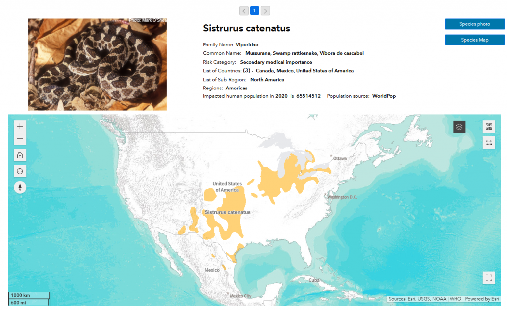
The World Health Organization has developed a new platform to increase awareness and response to venomous snake bites. Through crowd-sourced mapping and reporting of snake spottings, they have created a habitat database for all known venomous snakes. Users can submit images that will be independently verified and geolocated. The hope is that this will be an educational tool at the local level as well as provide health agencies with information about snake habitats so that they can better provide anti-venoms to the areas that need them most. For more on this, click here.
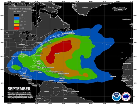
Mapping Tropical Storms by Month
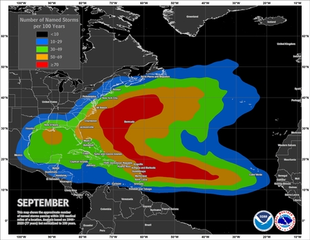
Understanding the nature of tropical storms and hurricanes is crucial to modeling them and predicting their tracks for the safety of those who live in regions most heavily affected. With our modern instruments, we can track and trace their paths like never before. NOAA has recently released some updated maps of storms from 1944-2020 and the results are very interesting. By mapping the number of named storms and hurricanes per 100 year period per month, you can see quite a good pattern and gain some good insights into what regions are most likely to be impacted by larger storms in a given year. These maps, for both the Atlantic and Pacific, along with many other interesting maps can be found here.
JM





Be the first to comment