
- NOAA Upheaval Raises Concerns as U.S. Nears Peak Hurricane Season
- India’s Private Space Industry to Launch 12-Satellite EO Network Under PPP
- What’s Next for Landsat and Civilian Earth Observation
- Mapping the Future: Google AlphaEarth Foundations in CARTO
- UK Space Agency to Merge into Department for Science, Innovation and Technology
- Preventing Tomorrow’s Fires Today
NOAA Upheaval Raises Concerns as U.S. Nears Peak Hurricane Season
The U.S. is heading into peak hurricane season amid major staffing cuts at NOAA and its National Weather Service. Nearly 2,000 jobs have been eliminated, raising concerns that fewer meteorologists and reduced data collection, such as fewer weather balloons and hurricane hunter flights, will weaken forecasting. Experts warn this could delay critical warnings as storms become more intense due to climate change. Local officials stress that timely, accurate NOAA data underpins public safety decisions, and Canada also relies on it. Further proposed budget cuts risk shuttering research labs, leaving communities more vulnerable as extreme hurricanes grow more frequent.
Full story here.
More details here.
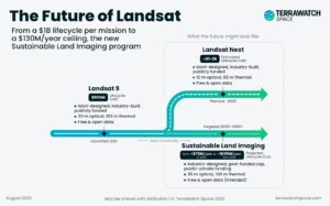
What’s Next for Landsat and Civilian Earth Observation
For over 50 years, Landsat has provided trusted, open Earth Observation data vital for agriculture, water, climate, and urban planning. Now NASA is exploring a new model: instead of billion-dollar satellites, the Sustainable Land Imaging program proposes a capped $70–$130M annual budget, relying on commercial partners to deliver “Landsat-class” data. While industry can build high-resolution systems, few maintain the calibration and stability essential for multi-decade science. Key questions remain: who guarantees long-term stewardship, will data stay open, and can businesses sustain quality under tight budgets? The outcome could redefine global EO missions or risk disrupting data continuity.
Dive deeper into the story here.
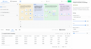
Mapping the Future: Google AlphaEarth Foundations in CARTO
CARTO has integrated Google DeepMind’s AlphaEarth Foundations into its Workflows platform, bringing powerful “satellite embeddings” into low-code geospatial analysis. AlphaEarth condenses petabytes of multimodal Earth observation data—optical, radar, and climate—into 64-dimensional annual vectors at 10-meter resolution. This allows analysts to skip raw imagery processing and instead use compact, analysis-ready features for classification, clustering, and predictive modeling. Applications span insurance, telecom, finance, logistics, and public sector planning, with wildfire risk detection in Arizona showcased as an example. The move signals a new era of geospatial AI, enabling scalable, accurate, and accessible environmental intelligence for decision-makers.
Full report here.
UK Space Agency to Merge into Department for Science, Innovation and Technology
The UK Government has announced that the UK Space Agency (UKSA) will become part of the Department for Science, Innovation and Technology (DSIT) by April 2026. The move aims to streamline space policy and delivery by cutting duplication, increasing ministerial oversight, and aligning with the government’s Plan for Change. While officials argue this integration will boost efficiency and accountability, critics warn it could add bureaucracy and weaken UKSA’s independent, agile approach. Founded in 2010, UKSA generated £2.2 billion for the space sector in 2024/25. The long-term impacts on innovation and international collaboration remain uncertain.
More details here.
Preventing Tomorrow’s Fires Today
Voltair, a startup founded by two recent University of Washington engineering graduates, Ronan Nopp and Hayden Gosch, is tackling wildfire risk from aging rural power lines using autonomous drones. Their self-charging drones can attach to power lines, recharge, and continue inspections every 60 days—far faster and cheaper than manual checks that can take years. Equipped with sensors, GIS mapping, and machine vision, the drones detect vegetation, heat, or equipment failures before sparks occur. After winning major UW entrepreneurship competitions and $45,000 in prizes, the team is refining prototypes, running field tests, and preparing to bring their wildfire-prevention technology to utilities.
Read more in detail here.


Be the first to comment