
- Students Use Drones and Smartphones to Map Historic Cemetery
- European Governments Push for Digital Sovereignty Amid U.S. Tech Dependence Concerns
- Satellite Record Shows Boreal Forest Expanded 12% and Shifted North Since 1985
- UC San Diego-Led EDGE Satellite Mission Selected by NASA
- Singapore to Establish National Space Agency in 2026
- NV5 Launches GeoAgent for Autonomous Geospatial Intelligence
Students Use Drones and Smartphones to Map Historic Cemetery
Students at Miami University helped the city of Oxford, Ohio digitally map a 40-acre cemetery containing more than 6,000 individuals after the city inherited only paper records. Using drone imagery and smartphone-based data collection tools, students pre-mapped headstones remotely and then verified and photographed them on site.
The updated workflow reduced field time significantly compared to traditional GPS-based methods and resulted in a searchable web application for the city and families. The project demonstrates how accessible geospatial tools can support local governments while preserving community history.

European Governments Push for Digital Sovereignty Amid U.S. Tech Dependence Concerns
Governments across Europe are reassessing their reliance on U.S. technology providers as concerns grow over data control and strategic autonomy. France announced that 2.5 million civil servants will transition away from platforms such as Zoom and Microsoft Teams in favour of a domestic video conferencing system by 2027, citing security and sovereignty concerns. Meanwhile, Estonia is trialling European software alternatives even as it continues migrating thousands of government workstations to Microsoft’s centrally managed cloud.
The shift reflects broader worries about dependence on foreign-controlled cloud infrastructure, satellite communications, and digital platforms that underpin public administration, defense, and scientific research. For the geospatial sector, these discussions extend beyond office software. National mapping agencies, Earth observation archives, and spatial data infrastructures increasingly rely on cloud-hosted systems. Questions of who controls the infrastructure, where data is stored, and under which legal framework it operates are becoming central to long-term digital resilience planning across Europe.
Read the full stories here and here

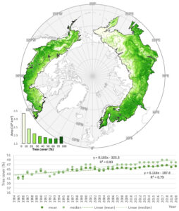
Satellite Record Shows Boreal Forest Expanded 12% and Shifted North Since 1985
A new study using the longest high-resolution satellite record of tree cover has found that the boreal forest has expanded by 12% and shifted northward over the past four decades. Researchers analyzed more than 224,000 Landsat scenes from 1985 to 2020, applying machine learning techniques to produce annual 30-metre resolution maps across the entire boreal biome.
The results show an expansion of approximately 0.84 million square kilometres, with growth concentrated between 64°N and 68°N. The study also highlights the carbon storage potential of newly established forests. By leveraging long-term Landsat archives and calibrated MODIS data, the research demonstrates the value of consistent, high-resolution satellite records for tracking ecosystem change at continental scale.
UC San Diego-Led EDGE Satellite Mission Selected by NASA
NASA has selected the Earth Dynamics Geodetic Explorer (EDGE), led by UC San Diego’s Scripps Institution of Oceanography, under its Earth System Explorers program. The mission, which could launch as early as 2030, will be the first global satellite imaging laser altimeter system.
EDGE will use swath-mapping lidar to measure the height and structure of land, vegetation, ice sheets and coastal regions. Building on the legacy of ICESat-2 and GEDI, the mission aims to extend long-term elevation records and improve monitoring of ecosystem and cryosphere change.

Singapore to Establish National Space Agency in 2026
Singapore will establish the National Space Agency of Singapore (NSAS) on 1 April 2026 to lead the country’s space missions. The new agency, under the Ministry of Trade and Industry, will build on the work of the Office of Space Technology & Industry and expand Singapore’s role in the global space economy.
NSAS will focus on strengthening research and development, growing the domestic space industry, developing national space capabilities and advancing international partnerships. With around 70 space companies already operating in Singapore, the move signals a coordinated effort to support satellite services, navigation, maritime monitoring and climate applications.

NV5 Launches GeoAgent for Autonomous Geospatial Intelligence
NV5 has introduced GeoAgent, an agentic AI platform designed to automate geospatial analysis workflows using natural language interaction. Rather than functioning as a standalone tool, GeoAgent operates as an orchestration layer across existing datasets, software and systems.
The platform is designed to discover, retrieve and analyze spatial data, producing explainable outputs while reducing the need for tool-specific workflows. NV5 positions GeoAgent as a step toward more automated, intent-driven geospatial intelligence, aimed at accelerating decision-making in operational environments.


Be the first to comment