- AlphaGeo publishes resilience analytics based on ‘ground truth’ using a novel geospatial platform
- Explore navigation using Google Maps’ geospatial augmented reality(AR) content
- Maxar Intelligence and Lockheed collaborate to improve the F-35 Full Mission Simulator
- Recent satellite data shows global deforestation across ecosystems
- Mapping all National Highways using GIS
- An improved coastal elevation model improves vertical precision
AlphaGeo publishes resilience analytics based on ‘ground truth’ using a novel geospatial platform
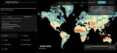
A new geospatial platform called AlphaGeo has been introduced. It combines localized risk and adaptation data and offers full resilience analytics for any region in the world. The platform integrates flood barriers and seawalls with an adaptability layer that incorporates risk predictions. Governments and corporations may better identify and solve resilience gaps with the use of this data. To help with risk management and strategic planning, users may access this data in a variety of ways, such as a corporate SaaS platform or Snowflake. With its insights into geographic dynamics, AlphaGeo’s platform helps investors make wise investment choices. On the AlphaGeo website, users may build bespoke portfolios; see example here at https://alphageo.ai/explore/. Read the full article here.
Explore navigation using Google Maps’ geospatial augmented reality (AR) content

To improve navigation, Google Maps is providing geographical augmented reality (AR) content. This test programme, which is initially available in Singapore and Paris, lets users interact with augmented reality overlays using the Street View and Lens features. Through deep link URLs or QR codes, users may virtually explore locales and share their experiences. The programme showcases historical and cultural locations, like the 1900 World’s Fair pavilions in Paris and Chinatown in Singapore. The incorporation of geographically augmented reality seeks to enhance user interaction by offering cultural insights, historical background, and useful information. The programme could extend to many cities throughout the globe if it is successful. Find out more information here.
Maxar Intelligence and Lockheed collaborate to improve the F-35 Full Mission Simulator
A long-term contract has been signed between Maxar Intelligence and Lockheed Martin to integrate Maxar’s geospatial products into the F-35 Full Mission Simulator (FMS). Maxar’s 2D and 3D products, such as Dynamic basemaps and Precision3D, will now have uniform pricing, licencing, and requirements thanks to this agreement. By offering accurate depictions of actual settings, these items enhance pilot training and mission preparedness. High-precision 3D models are provided by Precision3D, while high-resolution picture layers are produced by Dynamic imagery basemaps. Maxar’s Susanne Hake underlined that the goal of this collaboration is to improve the FMS experience while promoting pilot safety and mission success. Find out more details here.
Recent satellite data shows global deforestation across ecosystems
The OPERA DIST-ALERT system shows deforestation occurring globally in a variety of habitats, such as croplands, managed forests, grasslands, and shrublands, combined with data from the European Space Agency’s Sentinel-2 satellite and NASA’s Landsat satellite. This technology, which was created by NASA, the World Resources Institute, and the University of Maryland, offers notifications about vegetation disturbances almost instantly. As opposed to earlier instruments that concentrated on tropical rainforests, OPERA DIST-ALERT monitors disturbances in a variety of plant types, recording the effects of cyclones, fires, logging, and increased agricultural activity. The system’s goal is to enhance the worldwide detection and reaction to vegetation loss, including deforestation. Collect details here.
Mapping all National Highways using GIS

The Indian government plans to improve planning, implementation, and monitoring by finishing the GIS mapping of all national highways. Marking their domains is a responsibility assigned to organisations such as NHAI, BRO, and NHIDCL by the Ministry of Road Transport and Highways (MoRTH). By streamlining data gathering, this GIS-based method seeks to guarantee accuracy and transparency. Many miles of roadways have already been mapped by the Bhaskaracharya National Institute for Space Applications and Geo-informatics (BISAG-N), with field units confirming the information. Enhancing network planning, strategic maintenance, and resilient infrastructure development will be facilitated by the GIS system, which will increase investor trust in transportation projects. Find more details here.
An improved coastal elevation model improves vertical precision
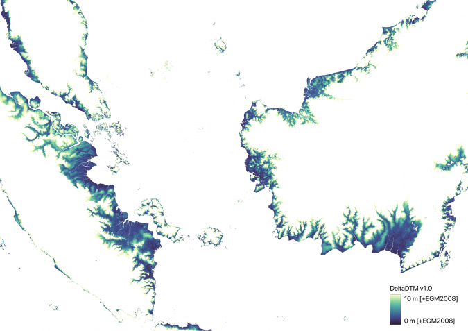
Using cutting-edge remote sensing data, scientists at Deltares have developed DeltaDTM, a worldwide coastal digital terrain model with 1 metre of vertical precision. This model, created in partnership with Delft University of Technology, combines NASA’s ICESat-2 and GEDI satellite Lidar data with radar-based CopernicusDEM to improve upon earlier elevation models. The shortcomings of current global elevation models, which frequently estimate developed and vegetated regions incorrectly, are addressed by DeltaDTM. The model provides useful information for coastal flood risk assessments and other geospatial applications, improving the evaluation of sea-level rise, subsidence, and storm surge consequences. With the availability of fresh data, more advancements are anticipated. Read full article here.


Be the first to comment