
- Saving Dying Reefs with Earth Engine and AI
- Bureaucratic Issues Facing a Joint European Space Conglomerate
- ESA Biomass Satellite returning long-awaited images
- NASA Sensor Identifying Polluted Run-off on California Coast
- Redrawing the Global Tea Map Due to Climate Change
- LiDAR Aiding Thermographic Analysis in Antarctica
Saving Dying Reefs with Earth Engine and AI
The changing global climate is killing off global reefs at an alarming pace, and Australia is no stranger to this, as it is home to the Great Southern Reef, one of the largest and most diverse marine ecosystems in the world. Formerly home to large kelp forests, some scientists suspect that restoring these ecosystems could be critical to restoring the overall health of the nearby reefs, along with being a large natural carbon sink. By using Google Earth Engine and AI models to map the coastal kelp canopy, project leaders hope to identify heat-resistant strains of kelp that have survived thus far and reintroduce the species in areas that have been more negatively impacted thus far. An important collaboration between geospatial analysis and AI, this could have huge impacts for ecosystems worldwide if this proves to be a successful collaboration. Learn more here.
Bureaucratic Issues Facing a Joint European Space Conglomerate
“Project Bromo”, a plan to create a European competitor to Starlink and China spearheaded by Airbus, Leonardo, and Thales, is taking longer to get off the ground than initially thought. As part of the global movement to diversify away from dependency on American offerings, the French and Italian companies are looking to join forces to strengthen sovereign capacity when it comes to geointelligence and commercial satellite capabilities. However, they are facing more pushback from European regulators, as well as experiencing extended debate on cost, which has led to them considering reaching out to Germany and Spain to achieve the increased scale while also sharing costs. To learn more about this developing conglomerate, click here.
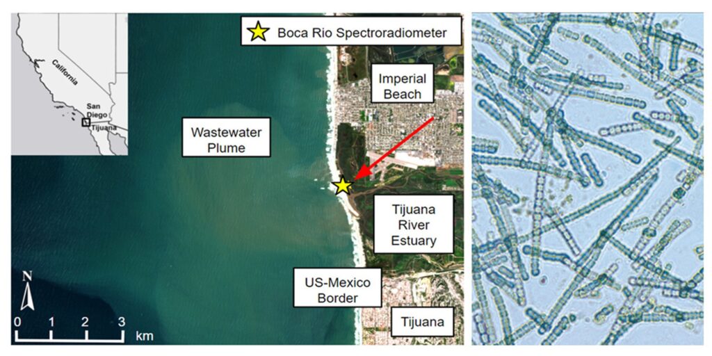
NASA Sensor Identifying Polluted Run-off on California Coast
With the increasing number of satellites surrounding the world, there are bound to be discoveries of unknown capabilities found in the data that is constantly being collected. A recent study found that the NASA-built Earth Surface Mineral Dust Source Investigation (EMIT) instrument on the ISS can be applied in new and unintended ways. Originally built to use spectroscopy to analyze the sunlight reflecting off the planet, the study discovered that the instrument could identify harmful bacteria and sewage in the outflow of the Tijuana River. By comparing EMIT’s readings with ground-sourced observations, the scientists found that EMIT could detect “a spectral fingerprint pointing to phycocyanin, a pigment in cyanobacteria, an organism that can sicken humans and animals that ingest or inhale it.” To find out more about this unexpected application of EMIT’s sensors, click here.
ESA Biomass Satellite returning long-awaited images
The ESA’s Biomass satellite mission is returning its first images after launching less than two months ago. While the project is still very much in its adjusting to orbit phase, the first images are impressing scientists looking to use the data to improve our ability to understand global carbon cycles and the Earth’s changing forests. A synthetic aperture radar satellite that runs in the P-band, researchers are hoping to measure woody biomass such as trunks, branches and stems. Simonetta Cheli, ESA’s Director of Earth Observation Programmes said,
“Looking at these first images, it’s clear to see that our Earth Explorer Biomass satellite is set to deliver on its promise.
“We fully expect that this new mission will provide a groundbreaking leap in our ability to understand Earth’s forests – combining cutting-edge radar technology with the scientific excellence that will unlock vital insights into carbon storage, climate change, and the health of our planet’s precious forest ecosystems.”
To learn more about this exciting mission and see some more of the first images, click here.
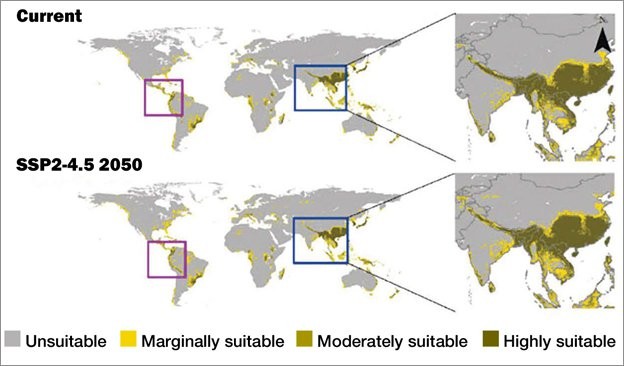
Redrawing the Global Tea Map Due to Climate Change
A new study from published in Environmental and Sustainability Indicators suggests that climate change will significantly impact the global tea industry by mid-century, leading to a shift in suitable climates for the optimal cultivation of tea plants. Using up-to-date climate modeling and sustainability mapping, this is one of the most detailed forecasts for the industry yet, by a joint team from Assam University in India, the University of Wisconsin, and Addis Ababa University. Some countries such as Kenya and Sri Lanka, who are among the world’s top growers, could lose 26-30% and 14% of their optimal growing areas, respectively. To learn more about how the global tea industry will be impacted, click here.
Lidar iding Thermographic Analysis in Antarctica
The combination of Lidar with thermographic sensors is leading to new and important insights at Antarctic research stations. The project, sponsored by the National Science Foundation, is looking to improve energy efficiency and structural resilience at American research stations. In these remote and extreme environments, minimizing energy consumption is critical to keep mission costs down. Mounting a VarioCAM HD head 880 thermal camera on a RIEGL VZ-1000 terrestrial laser scanner atop a survey tripod, enclosed in custom thermal jacket, allowed the team to create a 3D model of the South Pole Station’s west wing that led to the discovery of temperature anomalies around certain windows, revealing heat loss. To learn more about this exercise and its importance to polar research, click here.


Be the first to comment