
In This Edition
- AI Agents Could Reshape the Future of Geospatial Analysis
- China Expands Satellite Partnerships Across Africa
- Satellite Imagery Helping Speed Recovery in Disaster Zones
- New Flood Mapping Tool Could Improve Early Warning Systems
- GPS Interference Is Emerging as a Serious Geospatial and Aviation Risk
- New Research Explores Advances in Geospatial Data Systems
AI Agents Could Reshape the Future of Geospatial Analysis
Artificial intelligence is rapidly changing how geospatial data is analyzed, and a new generation of AI agents may soon automate many traditional GIS workflows. These systems can ingest large volumes of satellite imagery and geospatial datasets, detect patterns, and generate analytical outputs with minimal human intervention. As Earth observation data volumes continue to grow dramatically, AI-driven tools are becoming essential for processing and interpreting spatial information at scale. The integration of AI agents into geospatial platforms could significantly accelerate applications ranging from environmental monitoring to infrastructure analysis and geospatial intelligence.
Why it matters: AI is quickly becoming the core analytical engine behind modern geospatial systems.
Read more: View article
China Expands Satellite Partnerships Across Africa

China’s growing role in the global space sector continues to expand as Geely pursues satellite partnerships with African nations including Algeria and Morocco. These agreements aim to support satellite-based services such as navigation, communications, and remote sensing. The deals reflect a broader global trend in which countries and commercial firms are investing heavily in space infrastructure to support geospatial services. As satellite capabilities become a key component of national digital infrastructure, international partnerships like these are shaping the future of the global geospatial ecosystem.
Why it matters: Space-based geospatial infrastructure is becoming a major arena for global technological competition.
Read more: View article
Satellite Imagery Helping Speed Recovery in Disaster Zones

Satellite imagery is increasingly supporting disaster response and recovery operations around the world. A recent initiative highlighted by the United Nations Institute for Training and Research (UNITAR) demonstrates how Earth observation data can guide rebuilding efforts in regions affected by conflict and natural disasters. By providing timely geospatial insights into damaged infrastructure and environmental conditions, satellite data helps humanitarian organizations and governments prioritize recovery efforts and allocate resources more effectively.
Why it matters: Earth observation is becoming an essential operational tool for disaster management and humanitarian response.
Read more: View article
New Flood Mapping Tool Could Improve Early Warning Systems
Researchers at Arizona State University have developed a new geospatial flood-mapping tool designed to improve early warning capabilities and help communities prepare for flooding events. The system integrates multiple environmental datasets to model flood risks and generate clearer visualizations of potential inundation zones. As extreme weather events become more frequent, improved geospatial modelling tools are playing a growing role in helping emergency planners and policymakers anticipate risks and respond more effectively.
Why it matters: Better geospatial modelling tools are critical for climate resilience and disaster preparedness.
Read more: View article
GPS Interference Is Emerging as a Serious Geospatial and Aviation Risk
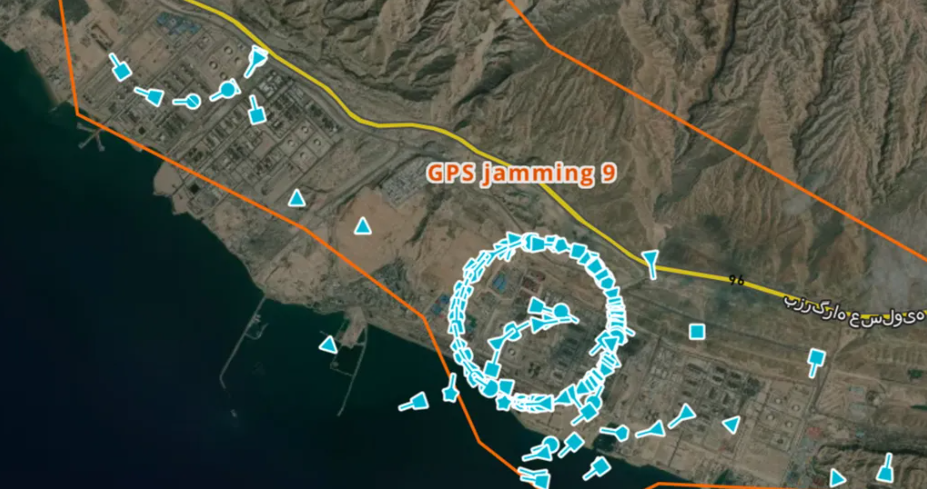
Growing concern over GPS interference is drawing attention to the vulnerability of satellite-based navigation systems used in aviation and other sectors. Recent reporting highlights how jamming, spoofing, and other forms of signal disruption are becoming more common in some regions, creating operational and safety risks for aircraft and other users that depend on reliable positioning data. The issue underscores the importance of resilient geospatial infrastructure and the need for stronger safeguards around global navigation satellite systems.
Why it matters: GNSS disruption is no longer a niche technical issue. It is becoming a real infrastructure and security concern.
Read more: View article
New Research Explores Advances in Geospatial Data Systems
A recently published academic study examines advances in geospatial data systems and the challenges of integrating complex spatial datasets across scientific disciplines. The research highlights how improvements in data interoperability, spatial modelling techniques, and analytical frameworks are helping scientists better understand environmental and geographic processes. As geospatial datasets continue to expand in scale and complexity, new approaches to managing and analyzing spatial information are becoming increasingly important.
Why it matters: Interoperable geospatial data systems are essential for integrating large and diverse spatial datasets.
Read more: View article


Be the first to comment