
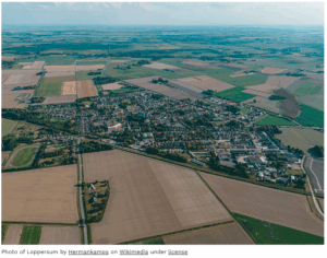
- The Geospatial Capabilities of Microsoft Fabric and ESRI GeoAnalytics, Demonstrated
- New Tube map celebrates London’s grassroots music venues and history
- Geospatial Reasoning: Unlocking insights with generative AI and multiple foundation models
- Geospatial Analytics Market Rising Demand and Growth Forecast Through 2033
- Center for Geospatial Analytics Students Tackle Real-World Problems Across the Southeast
- From satellites to strikes: Why Operation Sindoor is proof that geospatial tech is crucial for modern warfare
The Geospatial Capabilities of Microsoft Fabric and ESRI GeoAnalytics, Demonstrated
Data in the modern era typically has a high association with spatial elements. With data collection getting more efficient these days, data volumes are getting put under heavy constraints. The suggested work around for common data engines, which consist of textual data, needs adaptation with vector-type geospatial data by using spatial indexing to compute more efficiently. The article goes into detail, with coding, to help with the machine learning process. Read more, and see the coding behind this process here.
New Tube map celebrates London’s grassroots music venues and history
London’s music history is quite extensive, and what better way to showcase this than a than a tube map of all the grassroot music scenes. Different lines are highlighted and showcases the venues associated with the different lines. Geospatial data can also help map out the history of the arts, and the graphic below best showcases this. Read more here on what the Mayor of London said about this music campaign.

Geospatial Reasoning: Unlocking insights with generative AI and multiple foundation models
Google has pushed to improve their geospatial modeling and generative AI models. The intention of this pursuit is to “reduce the significant cost, time, and domain expertise required to combine geospatial capabilities”. With improved geospatial modelling, the end goal is to simplify and accelerate real-world problem solving. Read more on the Geospatial Reasoning tactics here.
Geospatial Analytics Market Rising Demand and Growth Forecast Through 2033
The dollar value of the geospatial market keeps rising over recent years. Industries are looking to adapt and advance in location-based services, satellite and drone technologies, and the growing demand for real-time data. Agriculture, urban planning, defense, transportation, and disaster management all use spatial data visualization and predictive analytics to create better products for clients and improve their internal databases and time management. Understanding the financial report in this article can help businesses make current decisions on trends that will allow the to compete in a rapidly changing environment. Read more here.
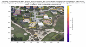
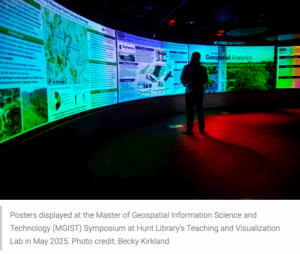
Center for Geospatial Analytics Students Tackle Real-World Problems Across the Southeast
NC State University has their Master of Geospatial Information Science and Technology students showcasing their capstone projects. The projects ranged in many subjects from environmental to urban growth, but the main take away was how these technical geospatial tools can greatly help in addressing problems within these sectors by not only demonstrating the analytics, but showcasing them with visual aids. Read more on the capstone projects here.
From satellites to strikes: Why Operation Sindoor is proof that geospatial tech is crucial for modern warfare
The India/Pakistan conflict has again brought to light on the wide spread use of geospatial technology. The advancements of not only the accuracy of geospatial data, but the ability to provide real time data at such high levels of accuracy shows how countries are investing in geospatial tech for defence purposes too. Read more details on the applications here.


Be the first to comment