
- Misinterpreted Google Earth Image Sparks Viral Claims Amid Sudan Conflict
- Mapping Britain on Foot: One Man’s 1,600-Mile Quest for Google
- MIT Develops Rapid 3D Mapping System for Search-and-Rescue Robots
- GIS Adoption Accelerates as Japan Strengthens Disaster Resilience
- Geospatial Intelligence Powers Humanitarian Response to Hurricane Melissa
- Trimble Unveils ProjectSight 360 for Remote 3D Tracking
Misinterpreted Google Earth Image Sparks Viral Claims Amid Sudan Conflict
In late October 2025, following reported atrocities by the Rapid Support Forces (RSF) in El-Fasher, a Google Earth screenshot circulated online, allegedly showing mass killings in Sudan. The post, shared on November 3 on X, described the image as “the most disturbing Google Earth image ever” and quickly gained over 15 million views.
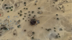
However, the image was old and misinterpreted—the dark patch actually depicts livestock in Kumia, southern Sudan, not human casualties. The incident underscores how satellite imagery can be misunderstood and misused to amplify narratives during conflicts. Experts emphasize the need to verify geospatial images before sharing, particularly in sensitive humanitarian crises, to prevent misinformation from spreading.
Mapping Britain on Foot: One Man’s 1,600-Mile Quest for Google
Dr. Uy Hoang, 51, a statistician from the University of Oxford, has spent the past decade mapping Britain’s waterways, driven by the frustration of not being able to see his local town path online. Starting in 2015, he has walked an estimated 1,600 miles along rivers and canals, capturing over 300,000 images and uploading them to an online mapping service. This dedication has made him Britain’s most prolific contributor and the ninth most active contributor worldwide.
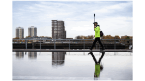
Using a $1,000 Insta360 camera, Dr. Hoang spends eight to ten hours daily covering paths that are inaccessible to Google Street View cars, focusing on areas like canals, rivers, and local walking or cycling paths. So far, he estimates he has mapped at least 75% of the nation’s canal network. His personal project highlights how individual initiative can enhance digital mapping and public access to remote or less-traveled route.
Read full article : Mapping On Foot
MIT Develops Rapid 3D Mapping System for Search-and-Rescue Robots
MIT researchers have developed a new approach enabling robots to rapidly map large, unpredictable environments—crucial for applications like search-and-rescue in collapsed mines. Traditional machine-learning models using onboard camera images can only handle a few images at a time, limiting their ability to navigate quickly.
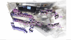
By combining modern AI vision models with classical computer vision techniques, the new system can process an arbitrary number of images, generating accurate 3D maps of complex scenes within seconds. This breakthrough allows robots to efficiently traverse large areas, locate people or hazards, and make real-time decisions, significantly improving their effectiveness in time-critical disaster scenarios.
Read full article : MIT Robot for mapping
GIS Adoption Accelerates as Japan Strengthens Disaster Resilience
Japan’s Geographic Information System (GIS) market, valued at US$384.06 million in 2024, is projected to reach US$851.34 million by 2033, growing at a 9.68% CAGR. The country’s high vulnerability to natural disasters drives GIS adoption, with the government allocating a supplemental 13.9 trillion JPY budget for fiscal year 2025, including 7.2 trillion JPY for public safety and advanced disaster mitigation technologies.
GIS tools have proven critical during emergencies, exemplified by the 2024 Noto Peninsula Earthquake, where AI-powered service Spectee Pro provided verified crisis information and has since secured over 1,100 contracts with local governments and companies. Additionally, the Prime Minister’s Cabinet Office has invested US$100 million in 2025 to strengthen the new central Disaster Prevention Agency, deploying officials across all 47 prefectures.
This strategic focus highlights geospatial data’s central role in enhancing national disaster preparedness, safeguarding communities, and supporting resilient infrastructure across Japan.
Read full article : Japan & GIS
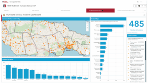
Read full article: Hurrican Melissa
Trimble Unveils ProjectSight 360 for Remote 3D Tracking
Trimble has launched ProjectSight 360 Capture, a new feature that enhances remote construction project visualization and progress‑to‑plan tracking.
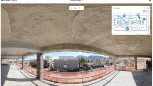
The tool integrates with 360‑degree cameras, Trimble ProjectSight software and Trimble Connect to enable virtual jobsite walkthroughs. AI‑powered algorithms automatically process and align imagery with project drawings, enabling contractors to track changes, identify issues, and embed captures into workflows like RFIs and change‑orders. The system is designed to streamline documentation, improve collaboration between field and office, and give project managers real‑time insights into site conditions and project status. It will be available in North America in 2026 as an add‑on to ProjectSight
Read full article: ProjectSight 360


Be the first to comment