
- Hurricane Helene: NOAA Reflects on the Deadliest U.S. Storm Since Katrina
- NASA Faces Major Uncertainty Amid U.S. Govt
- Team Rubicon Uses GIS to Drive Disaster Response
- ESA’s HydroGNSS Mission to Track Global Water and Climate Patterns
- ESA Cautions Against Industry Monopolies as Major Satellite Merger Nears
- Underground Data Fortresses: Securing the World’s Digital “Gold”
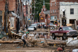
Hurricane Helene: NOAA Reflects on the Deadliest U.S. Storm Since Katrina
NOAA’s Asheville-based team looks back at Helene’s impact across the Southern Appalachians. The storm and a predecessor rainfall event brought catastrophic inland flooding, more than 200 deaths, and an estimated $78.7B in damages (7th-costliest U.S. tropical cyclone on record). Western North Carolina saw more than 30 inches of rain in places, about 42 trillion gallons fell across the region, and over 60 river gauges beat historic peaks. Wind gusts topped 100 mph, with 822,000 acres of timberlands damaged, and some communities faced weeks without power, cell service, or safe water. The review highlights new tools and updates underway, including Flood Inundation Mapping that now covers 60% of the U.S. population and the coming Atlas-15 rainfall extremes update, plus an interactive dashboard and before–after visuals.
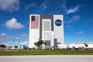
NASA Faces Major Uncertainty Amid U.S. Govt Shutdown
As the U.S. government edges toward a shutdown, NASA’s future hangs in the balance. The Office of Management and Budget (OMB) has directed federal agencies to prepare reduction-in-force plans, not just temporary furloughs, if Congress fails to pass a stopgap funding bill before the new fiscal year. Under the current Presidential Budget Request, NASA could face a 25% funding cut and lose nearly one-third of its workforce, dropping to its smallest size since the Apollo era.
While the proposal boosts Mars exploration funding, it slashes science missions by almost half, sparking backlash from groups like The Planetary Society and the Mars Society. Lawmakers are now pushing to include protective language in any continuing resolution to prevent mission shutdowns and layoffs. Without it, ongoing programs, including the Artemis missions, could be disrupted, threatening U.S. leadership in space exploration.
Team Rubicon Uses GIS to Drive Disaster Response
When hurricanes strike, humanitarian teams have just hours to act. For veteran-led nonprofit Team Rubicon, Geographic Information Systems (GIS) have become indispensable tools for saving lives. Before storms make landfall, GIS analysts overlay hurricane forecasts with population data, flood zones, and available response resources to plan where to deploy first. Once in the field, responders use mobile apps like ArcGIS Field Maps and Survey123 to share live updates, mapping blocked roads, damaged homes, and areas still without power.
After the storm, GIS dashboards help identify communities with the greatest unmet needs, ensuring that aid reaches those who need it most. In the wake of Hurricane Helene, this approach helped Team Rubicon locate underserved areas and coordinate with other NGOs to avoid overlap. As the group expands its recovery efforts, GIS continues to guide decisions, from assessing insurance gaps after the Texas floods to training new responders. For Team Rubicon, every map tells a story of response, recovery, and human connection.
ESA’s HydroGNSS Mission to Track Global Water and Climate Patterns
The European Space Agency (ESA) is preparing to launch HydroGNSS, a dual-satellite mission designed to measure key hydrological climate variables using GNSS Reflectometry (GNSS-R). As part of ESA’s FutureEO Scout program, HydroGNSS adopts a small-satellite, fast-delivery approach to advance Earth science with a modest budget. The mission will monitor soil moisture, permafrost freeze/thaw states, wetland extent, and forest biomass, all essential climate variables critical for understanding global water cycles.
By capturing reflected GPS and Galileo signals, HydroGNSS can observe the Earth’s surface even through clouds, rain, and vegetation. The data will support weather forecasting, flood warnings, and climate modeling, providing a sustainable new tool for tracking how water shapes our planet.
ESA Cautions Against Industry Monopolies as Major Satellite Merger Nears
The European Space Agency (ESA) has warned that while consolidation may help Europe’s satellite sector compete globally, excessive concentration could harm competition and limit choice. Airbus, Leonardo, and Thales, the three European firms capable of delivering full satellite systems, are reportedly in talks for a €10 billion merger to strengthen their position against major players like SpaceX’s Starlink.
ESA Director of Operations Rolf Densing told Reuters that mergers could provide the “critical mass” needed to compete with U.S. and Chinese counterparts, but cautioned that having just one dominant provider “is not too helpful.” He also emphasized the need for Europe to achieve greater independence in space missions, noting the region’s continued reliance on foreign partners to launch astronauts. “The future of defence is in space,” Densing said, highlighting space’s growing role in security and autonomy.
Underground Data Fortresses: Securing the World’s Digital “Gold”
A growing number of companies are converting Cold War bunkers, mines, and mountain vaults into ultra-secure data centers to safeguard digital information, the backbone of modern mapping, navigation, and Earth observation systems. The story follows the Cyberfort bunker in the UK and similar facilities across Europe and North America, exploring how physical protection has become as critical as cybersecurity. As geospatial data grows in value, these underground “data fortresses” highlight the real-world infrastructure that keeps our digital maps and satellite archives safe.


Be the first to comment