

Kitchener-Waterloo’s March GoGeomatics Social will feature organizer Willie Carroll, who will be speaking on the use of 3D terrestrial laser scan data to analysis the Gomantong Cave network on the island of Borneo.
Willie will discuss the use of 3D terrestrial laser scan data to determine ancient water flow and movement within the cave. From identifying key features to having to working among hundreds of bats, Willie will explain the methods he took to determine how the cave was formed and how it continues to change today.
Please RSVP to this social on the Meetup Page.
Everyone is welcome, from all areas of geomatics – from GIS, to remote sensing, to surveying, to cartography, to GIS enthusiasts. If you are involved in location technology you are invited.
This fun, free networking event is an opportunity for people in the community to develop new relationships, learn more about current activities, technologies and success stories, and gain insight into the many advanced applications in Canada’s most advanced hi-tech region.
When: Wednesday, March 13, 2019
6:30 PM to 8:30 PM
Where: Huether Hotel, 59 King, Waterloo, ON
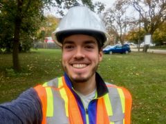
Speaker: Willie Carroll works as a GIS Analyst with SoilOptix. Willie completed his undergraduate program at Carleton University obtaining a Honours Bachelor of Arts of Physical Geography with a minor in Geomatics and a Post Graduate Certification in GIS at Algonquin College. Willie has a background in Environmental GIS, Agricultural GIS and Drone/UAV surveying.


Be the first to comment