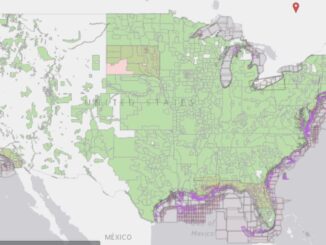
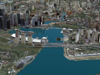
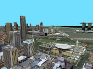
• facebook
  • Twitter
  • Linkedin
  • Youtube
  • Linkedin Group
  • Post a Job
  • Post an Ad
  • Post an Event
  • Post a Directory Listing
  • Post a Press Release
  • Media Kit
  • My Account
  • Login
GoGeomatics
  • MAGAZINE
    • BIM & GIS
    • Community
    • Conference news
    • Earth Observation
    • Education & Careers
    • GEOAI
    • Announcements
    • Reality Capture & Lidar
    • Science
    • Technology
    • Between the Poles
  • Directories
    • ASSOCIATION
    • INDUSTRY
    • EDUCATION
    • Open Data
  • EVENTS
    • GeoIgnite Events
    • Events Calendar
    • GoGeomatics Meetups
  • Services
    • Advertising
    • Marketing
    • Post a Job
    • Post an Ad
    • Post an Event
    • Post a Press Release
    • Post a Directory Listing
    • Media Kit
    • Web Design
  • Find a Job
  • Volunteer
    • Start a GoGeomatics Group
    • Editors & Writers Group
  • About Us
    • About Us
    • Contact Us
    • Frequently Asked Questions
  • Videos
HomeBetween the Poles – The Geoff Zeiss Archives3D cadastre

3D cadastre

3D cadastre

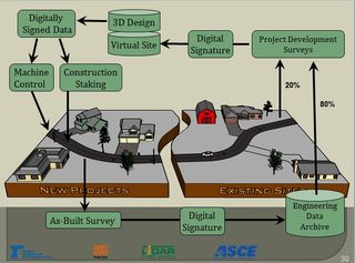
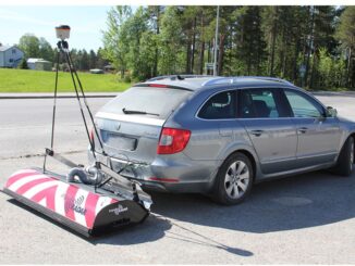
Scanning underground infrastructure with ground penetrating radar at up to 130 km/hour

16 July 2019 Geoff Zeiss

Underground utility damage during construction is a major safety problem and drag on economies in many countries.  The technologies that are currently considered best practices for detecting underground utilities have been used for decades and […]

3D cadastre

US 3D elevation project as a model for a national infrastructure map

24 September 2018 Geoff Zeiss

A number of years ago an initiative was funded under the ARRA economic stimulus package to initiate what was then called LiDAR for the Nation.  This has resulted in a USGS initiative called 3D Elevation […]

3D cadastre

Accelerating the rate of BIM adoption in Canada

20 February 2018 Geoff Zeiss

There is a general consensus that the development of BIM in Canada lags many other developed countries around the globe. This is partly due to little encouragement from government procurement at the federal and provincial […]

3D cadastre

SPAR2016: Digitalizing highway construction at the Oregon DoT

8 June 2016 Geoff Zeiss

At SPAR 2013Ron Singh, Engineering Automation Manager/Chief of Surveys, Oregon Department of Transportation (DoT) made a startling proposal that would stand the traditional highway construction process on its head by making the post-construction as-built survey […]

3D cadastre

Singapore’s national 3D model wins Be Inspired Award at YII2015

10 November 2015 Geoff Zeiss

At the the Year in Infrastructure conference in London the Singapore Land Authority (SLA) won the annual Be Inspired Award for Innovation in Government.  Comprising only 700 square kilometers for the entire nation, land is […]

3D cadastre

Be Inspired Awards at Year in Infrastructure 2015: Creating a 3D cadastre for Singapore

2 November 2015 Geoff Zeiss

Singapore, the Netherlands, Australia, Germany and Malaysia are on the leading edge of creating and maintaining 3D cadastres for their respective countries.  A 3D cadastre is in the cards for Singapore for several reasions; Land developers […]

3D cadastre

Progress on the Dutch 3D geospatial standard-integration with open source geospatial tools

1 May 2014 Geoff Zeiss

At the Geospatial World Forum in Amsterdam two years ago, Jantien Stoter of the Delft Univeristy of Technology and an advisor to Geonovum, gave an overview of the work on a Dutch 3D standard, which […]

3D cadastre

Indoor location tracking and mapping are developing rapidly

10 July 2012 Geoff Zeiss

One of the new generation of geospatial-related conferences that I have attended for two years now is Location Intelligence for Enterprise USA.  It is not a traditional GIS conference but includes talks about vertical business […]

Posts pagination

1 2 »

Events

Feb 16
February 16 @ 8:00 am - February 18 @ 5:00 pm

GeoWeek 2026

Feb 17
5:00 pm - 8:00 pm

Victoria GoGeomatics February Mappy Hour

Feb 17
6:00 pm - 8:00 pm

Calgary GoGeomatics February Social

Feb 18
6:30 pm - 8:30 pm

Vancouver GoGeomatics Meetup – February 2026

Feb 19
February 19 - February 22

Spatial Knowledge and Information Canada 2026

View Calendar

View All Events

Services

  • Post a Job
  • Post an Ad
  • Post an Event
  • Post a Directory Listing
  • Post a Press Release
  • Media Kit
  • My Account
  • Login

Jobs

Post a Job
  • Volunteer Editorial Contributor – Be Part of Canada’s Geomatics Story
    Remote
  • Junior Geomatics Field Technician – Technical Surveys
    Montréal, QC
  • GIS Specialist
    Amherst, Nova Scotia
  • Precast Structural BIM Specialist
    Calgary, Alberta
View All Jobs
  • Directories
    • Associations Directory
    • Industry Directory
    • Education Programs
    • Open Data
  • Volunteer
    • Start a GoGeomatics Group
    • Editors & Writers Group
  • About Us
    • GoGeomatics Media Kit
    • Who We Are
    • Contact Us
    • FAQ’s
    • Advertising
    • Marketing
  • Subscribe
GoGeomatics
GoGeomatics is the largest and most popular communications hub promoting the Canadian geospatial community. The business was incorporated in 2011. GoGeomatics hosts over 100 fun, free, location technology networking events each year in cities across Canada.

© 2026 GoGeomatics

  • facebook
  • Twitter
  • Linkedin
  • Youtube
  • Linkedin Group