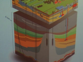
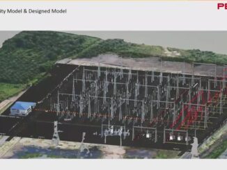
• facebook
  • Twitter
  • Linkedin
  • Youtube
  • Linkedin Group
  • Post a Job
  • Post an Ad
  • Post an Event
  • Post a Directory Listing
  • Post a Press Release
  • Media Kit
  • My Account
  • Login
GoGeomatics
  • MAGAZINE
    • BIM & GIS
    • Community
    • Conference news
    • Earth Observation
    • Education & Careers
    • GEOAI
    • Announcements
    • Reality Capture & Lidar
    • Science
    • Technology
    • Between the Poles
  • Directories
    • ASSOCIATION
    • INDUSTRY
    • EDUCATION
    • Open Data
  • EVENTS
    • GeoIgnite Events
    • Events Calendar
    • GoGeomatics Meetups
  • Services
    • Advertising
    • Marketing
    • Post a Job
    • Post an Ad
    • Post an Event
    • Post a Press Release
    • Post a Directory Listing
    • Media Kit
    • Web Design
  • Find a Job
  • Volunteer
    • Start a GoGeomatics Group
    • Editors & Writers Group
  • About Us
    • About Us
    • Contact Us
    • Frequently Asked Questions
  • Videos
HomeBetween the Poles – The Geoff Zeiss Archives3D data

3D data

3D data

Canadian standard specifies absolute precision for underground infrastructure exposed by excavation

25 February 2019 Geoff Zeiss

Infrastructure in the older cities of Canada was installed more than 100 years ago when as-built drawings, if any existed, referenced surface features that may have disappeared.  Recording the accurate location of such utilities was […]

3D data

Autodesk signals commitment to BIM + geospatial integration for improving construction productivity

21 February 2019 Geoff Zeiss

We are beginning to see data from real world projects that offer tangible evidence of the benefits of an integrated BIM+geospatial full lifecycle approach for construction projects.  A few firms such as Parsons Brinckerhoff, Atkins Global, […]

3D data

LiDAR changes the cost structure for utility distribution vegetation management

12 February 2019 Geoff Zeiss

Vegetation is a significant source of outages for many utilities. In some regions from one quarter to one half of all outages can be ascribed to vegetation.  Vegetation encroachment initiated the massive North American northeastern […]

3D data

Modeling multi-utility interdependent underground networks for disaster management in cities

5 February 2019 Geoff Zeiss

On this blog most of the discussion relating to underground infrastructure has been focused on construction focussing on the risks to workers and the public and the drag on the economics of construction.  There are […]

3D data

Progress toward a unified model for underground infrastructure and geology

8 January 2019 Geoff Zeiss

TNO, Geological Survey of the Netherlands Information about the location, condition and interdependencies of the infrastructure and geology below our feet is poor or lacking.  Even though information about what is below ground is revealed […]

3D data

Growing evidence of the benefits of an integrated BIM+geospatial full lifecycle approach to construction

2 January 2019 Geoff Zeiss

Building information modeling (BIM) has been applied to design-build construction projects for many years. A growing number of countries are mandating BIM for public projects.  While the UK government has said that “…we know that […]

3D data

3D BIM + geospatial full lifecycle metro rail project aims at eliminating data loss

27 December 2018 Geoff Zeiss

This year’s winner of a special recognition award at Year in Infrastructure was Maharashtra Metro Rail Corporation Ltd for its Nagpur Metro Asset Information Management System which implemented a digital twin and a tagging scheme […]

3D data

BIM and reality modeling eliminate change orders for brownfield substation expansion

11 December 2018 Geoff Zeiss

Companies are recognizing the benefits of an integrated geospatial and building information modeling (BIM) approach to design and construction. At Bentley‘s the Year in Infrastructure 2018 Conference in London, the winner of the Year in Infrastructure […]

Posts pagination

« 1 … 10 11 12 … 30 »

Events

Notice
There are no upcoming events.

View All Events

Services

  • Post a Job
  • Post an Ad
  • Post an Event
  • Post a Directory Listing
  • Post a Press Release
  • Media Kit
  • My Account
  • Login

Jobs

Post a Job
  • Volunteer Editorial Contributor – Be Part of Canada’s Geomatics Story
    Remote
  • Junior Geomatics Field Technician – Technical Surveys
    Montréal, QC
  • GIS Specialist
    Amherst, Nova Scotia
  • Precast Structural BIM Specialist
    Calgary, Alberta
View All Jobs
  • Directories
    • Associations Directory
    • Industry Directory
    • Education Programs
    • Open Data
  • Volunteer
    • Start a GoGeomatics Group
    • Editors & Writers Group
  • About Us
    • GoGeomatics Media Kit
    • Who We Are
    • Contact Us
    • FAQ’s
    • Advertising
    • Marketing
  • Subscribe
GoGeomatics
GoGeomatics is the largest and most popular communications hub promoting the Canadian geospatial community. The business was incorporated in 2011. GoGeomatics hosts over 100 fun, free, location technology networking events each year in cities across Canada.

© 2026 GoGeomatics

  • facebook
  • Twitter
  • Linkedin
  • Youtube
  • Linkedin Group