• facebook
  • Twitter
  • Linkedin
  • Youtube
  • Linkedin Group
  • Post a Job
  • Post an Ad
  • Post an Event
  • Post a Directory Listing
  • Post a Press Release
  • Media Kit
  • My Account
  • Login
GoGeomatics
  • MAGAZINE
    • BIM & GIS
    • Community
    • Conference news
    • Earth Observation
    • Education & Careers
    • GEOAI
    • Announcements
    • Reality Capture & Lidar
    • Science
    • Technology
    • Between the Poles
  • Directories
    • ASSOCIATION
    • INDUSTRY
    • EDUCATION
    • Open Data
  • EVENTS
    • GeoIgnite Events
    • Events Calendar
    • GoGeomatics Meetups
  • Services
    • Advertising
    • Marketing
    • Post a Job
    • Post an Ad
    • Post an Event
    • Post a Press Release
    • Post a Directory Listing
    • Media Kit
    • Web Design
  • Find a Job
  • Volunteer
    • Start a GoGeomatics Group
    • Editors & Writers Group
  • About Us
    • About Us
    • Contact Us
    • Frequently Asked Questions
  • Videos
HomeBetween the Poles – The Geoff Zeiss Archives3D data

3D data

3D data

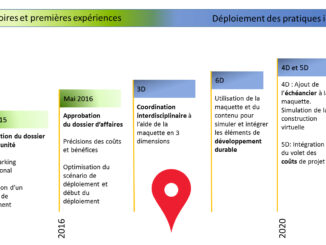
French national initiative to map all urban subsurface critical infrastructure by 2019

13 March 2018 Geoff Zeiss

I have blogged previously about a French presidential decree in 2012 that mandated that all of France’s critical underground utility infrastructure must be mapped in 3D to an accuracy of 40 cm (about 16 inches).  […]

3D data

P3 drives integrated geospatial + BIM in the Canadian construction industry

26 February 2018 Geoff Zeiss

Several years ago Rijkswaterstaat, the Dutch highway authority, initiated Design, Build, Finance and Maintain (DBFM) highway projects. Private Dutch engineering and construction companies bidding on these projects found that adopting an integrated geospatial + BIM […]

3D data

Large public project in U.S. mandates BIM for full-life-cycle construction

23 February 2018 Geoff Zeiss

One of the largest municipal bond-financed construction projects in the United States has mandated building information modeling (BIM), targetting not only design and construction, but as a permanent record of college assets for use during […]

3D cadastre

Accelerating the rate of BIM adoption in Canada

20 February 2018 Geoff Zeiss

There is a general consensus that the development of BIM in Canada lags many other developed countries around the globe. This is partly due to little encouragement from government procurement at the federal and provincial […]

No Picture
3D data

Automating sustainable building design using BIM and energy performance modeling

19 February 2018 Geoff Zeiss

At the CanBIM Regional Session in Vancouver, Mark Cichy, Associate, Director of Computational Design and Research, at DIALOG, gave a fascinating talk about automating the process of designing sustainable buildings.  Specifically the talk focussed on […]

3D data

High resolution satellite imagery helps innovative electric utility optimize vegetation management

5 February 2018 Geoff Zeiss

Vegetation is a significant source of outages for many utilities. In some regions from one quarter to one half of all outages can be ascribed to vegetation.  Vegetation encroachment initiated the massive North American northeastern […]

3D data

Electic power utility uses reality capture to rapidly develop grid data model

31 January 2018 Geoff Zeiss

Duquesne Light is typical of many of North American small to medium electric power utilities.  It does not have an outage management system  or an electrical data model which means it is difficult to connect customers […]

3D data

Top construction company AECOM applies BIM + geospatial for full lifecycle projects

18 January 2018 Geoff Zeiss

AECOM is a US$18.2 billion a year firm in the construction sector.  It designs and builds infrastructure around the world for public- and private-sector clients including transportation, facilities, environmental, energy, oil and gas, water, high-rise […]

Posts pagination

« 1 … 14 15 16 … 30 »

Events

Notice
There are no upcoming events.

View All Events

Services

  • Post a Job
  • Post an Ad
  • Post an Event
  • Post a Directory Listing
  • Post a Press Release
  • Media Kit
  • My Account
  • Login

Jobs

Post a Job
  • Volunteer Editorial Contributor – Be Part of Canada’s Geomatics Story
    Remote
  • Junior Geomatics Field Technician – Technical Surveys
    Montréal, QC
  • GIS Specialist
    Amherst, Nova Scotia
  • Precast Structural BIM Specialist
    Calgary, Alberta
View All Jobs
  • Directories
    • Associations Directory
    • Industry Directory
    • Education Programs
    • Open Data
  • Volunteer
    • Start a GoGeomatics Group
    • Editors & Writers Group
  • About Us
    • GoGeomatics Media Kit
    • Who We Are
    • Contact Us
    • FAQ’s
    • Advertising
    • Marketing
  • Subscribe
GoGeomatics
GoGeomatics is the largest and most popular communications hub promoting the Canadian geospatial community. The business was incorporated in 2011. GoGeomatics hosts over 100 fun, free, location technology networking events each year in cities across Canada.

© 2026 GoGeomatics

  • facebook
  • Twitter
  • Linkedin
  • Youtube
  • Linkedin Group