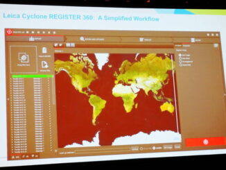
• facebook
  • Twitter
  • Linkedin
  • Youtube
  • Linkedin Group
  • Post a Job
  • Post an Ad
  • Post an Event
  • Post a Directory Listing
  • Post a Press Release
  • Media Kit
  • My Account
  • Login
GoGeomatics
  • MAGAZINE
    • BIM & GIS
    • Community
    • Conference news
    • Earth Observation
    • Education & Careers
    • GEOAI
    • Announcements
    • Reality Capture & Lidar
    • Science
    • Technology
    • Between the Poles
  • Directories
    • ASSOCIATION
    • INDUSTRY
    • EDUCATION
    • Open Data
  • EVENTS
    • GeoIgnite Events
    • Events Calendar
    • GoGeomatics Meetups
  • Services
    • Advertising
    • Marketing
    • Post a Job
    • Post an Ad
    • Post an Event
    • Post a Press Release
    • Post a Directory Listing
    • Media Kit
    • Web Design
  • Find a Job
  • Volunteer
    • Start a GoGeomatics Group
    • Editors & Writers Group
  • About Us
    • About Us
    • Contact Us
    • Frequently Asked Questions
  • Videos
HomeBetween the Poles – The Geoff Zeiss Archives3D data

3D data

3D data

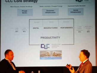
BIM + geospatial essential for improving UK construction productivity

29 June 2017 Geoff Zeiss

At GeoBusiness 2017 in London, Simon Rawlinson of Arcadis, argued passionately for improving the efficency of the construction industry, which is 8% of the UK’s GDP.  Digitalization, in which BIM + geospatial play a key […]

3D data

Perceptality: new laser scanning applications potentially transforming construction

26 June 2017 Geoff Zeiss

At HxGNLive Juergen Dold, President of Hexagon Geosystems which is responsible for the Leica Geosystems brand, gave a talk about perception and reality.  Perception is how we see the world, but perceptions are subjective and […]

3D data

The other half of the laser scanning revolution in construction

17 June 2017 Geoff Zeiss

I have already blogged about the Leica BLK360 whose size, capabilities, one button operation and price point promise to revolutionize professional scanning for construction.  Anyone who has used a Leica scanner is familiar with Cyclone […]

3D data

Industry standard tools for underground utility detection and mapping

15 June 2017 Geoff Zeiss

At HxGNLive in Las Vegas this week I attended a session on using Leica technology to locate underground assets presented by Brett Black, GIS Solutions, Simon Pedley, Utility Detection Solutions and Mike Baker, G/Technology Product […]

3D data

Practical BIM/laser-scan round tripping on construction projects

15 June 2017 Geoff Zeiss

At HxGNLive in Las Vegas this week a very interesting presentation with practical implications for anyone involved in construction, whether buildings or horizontal infrastructure was provided by Stanley Lawrence, Reid Flamm, and Michael Moore of […]

3D data

Simplifying the integration of reality capture and asset management

24 May 2017 Geoff Zeiss

The construction industry in the UK, as in many of the world’s advanced economies, suffers from low productivity compared to other industries, a situation which hasn’t improved in 25 years according to Simon Rawlinson of […]

3D data

Miniaturized imaging scanner captures CES Innovation Award

28 April 2017 Geoff Zeiss

The Leica BLK360 has won a CES 2017 Innovation Award.  The BLK360 is a miniaturized 3D imaging laser scanner that weighs about a kilogram. It captures full-color panoramic images overlaid on a millimeter accuracy point […]

3D data

Completely automated classification of 3D scans by next year ?

24 April 2017 Geoff Zeiss

Today’s 3D scanners are able to generate 3D models in which humans can easily recognize objects such as vegetation, ground, buildings, power transformers, utility poles and cables, and windows and doors.  Automating this process of […]

Posts pagination

« 1 … 17 18 19 … 30 »

Events

Notice
There are no upcoming events.

View All Events

Services

  • Post a Job
  • Post an Ad
  • Post an Event
  • Post a Directory Listing
  • Post a Press Release
  • Media Kit
  • My Account
  • Login

Jobs

Post a Job
  • Volunteer Editorial Contributor – Be Part of Canada’s Geomatics Story
    Remote
  • Junior Geomatics Field Technician – Technical Surveys
    Montréal, QC
  • GIS Specialist
    Amherst, Nova Scotia
  • Precast Structural BIM Specialist
    Calgary, Alberta
View All Jobs
  • Directories
    • Associations Directory
    • Industry Directory
    • Education Programs
    • Open Data
  • Volunteer
    • Start a GoGeomatics Group
    • Editors & Writers Group
  • About Us
    • GoGeomatics Media Kit
    • Who We Are
    • Contact Us
    • FAQ’s
    • Advertising
    • Marketing
  • Subscribe
GoGeomatics
GoGeomatics is the largest and most popular communications hub promoting the Canadian geospatial community. The business was incorporated in 2011. GoGeomatics hosts over 100 fun, free, location technology networking events each year in cities across Canada.

© 2026 GoGeomatics

  • facebook
  • Twitter
  • Linkedin
  • Youtube
  • Linkedin Group