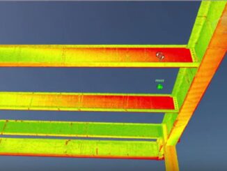
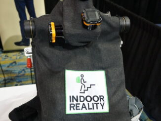
• facebook
  • Twitter
  • Linkedin
  • Youtube
  • Linkedin Group
  • Post a Job
  • Post an Ad
  • Post an Event
  • Post a Directory Listing
  • Post a Press Release
  • Media Kit
  • My Account
  • Login
GoGeomatics
  • MAGAZINE
    • BIM & GIS
    • Community
    • Conference news
    • Earth Observation
    • Education & Careers
    • GEOAI
    • Announcements
    • Reality Capture & Lidar
    • Science
    • Technology
    • Between the Poles
  • Directories
    • ASSOCIATION
    • INDUSTRY
    • EDUCATION
    • Open Data
  • EVENTS
    • GeoIgnite Events
    • Events Calendar
    • GoGeomatics Meetups
  • Services
    • Advertising
    • Marketing
    • Post a Job
    • Post an Ad
    • Post an Event
    • Post a Press Release
    • Post a Directory Listing
    • Media Kit
    • Web Design
  • Find a Job
  • Volunteer
    • Start a GoGeomatics Group
    • Editors & Writers Group
  • About Us
    • About Us
    • Contact Us
    • Frequently Asked Questions
  • Videos
HomeBetween the Poles – The Geoff Zeiss Archives3D data

3D data

3D data

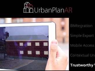
On-site AR visualization of BIM designs in an urban environment

2 August 2016 Geoff Zeiss

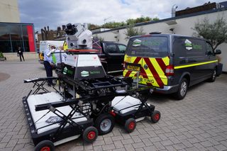
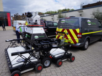
There are two advances in technology that are having almost as much impact on mapping our world and tracking the location of things in it as the introduction of the GPS.  The development of microelectromechanical […]

3D data

HxGN LIVE Precision mapping underground utilities with combined LiDAR and GPR

29 June 2016 Geoff Zeiss

One of the most exciting presentations at the annual Hexagon conference HxGN Live in Anaheim from the viewpoint of practical application of new technology was a talk given by Gilbert Roulier of Grunder Ingenieure AG, who […]

3D data

HxGN Live: 3D underground utility mapping, indoor mapping, UAVs and utility solutions

21 June 2016 Geoff Zeiss

Last week I had the opportunity to present at the annual Hexagon conference HxGN Live in Anaheim. Hexagon is a rapidly growing company with broad technology reach with core strengths in geospatial surveying and laser […]

3D data

Automating the process of comparing digital models to reality

30 May 2016 Geoff Zeiss

At the Spar 3D Expo and Conference in Houston I had the opportunity to chat with Nicolas Arnold, VP of Product Development at SKUR.  SKUR is a young software company that has just released its […]

No Picture
3D data

Geo Business 2016: Geo-enabling BIM – Call to action

27 May 2016 Geoff Zeiss

At this year’s Geo Business 2016 event in London two sessions were held focussing on geo-enabling building information modeling (BIM).  Sponsored by Survey4BIM, an initiative supported by the UK Government BIM Task Group, the meetings […]

3D data

Geo Business 2016: Advance in ground penetrating radar improves mapping of subsurface utilities

26 May 2016 Geoff Zeiss

A number of return on investment (ROI) studies have identified the significant benefits of knowing where underground utilities are located.  For example, a Pennsylvania State University study commissioned by the Pennsylvania DoT found a return on […]

3D data

SPAR2016: Greg Bentley on geo-coordination,mapping underground infrastructure, and information flow in construction

10 May 2016 Geoff Zeiss

At the Spar 3D Expo and Conference in Houston Greg Bentley gave a keynote in the morning in which he especially focused on reality modeling and how this technology had been applied to model in […]

3D data

Spar 3D: 3D mapping the inside of multi-story buildings with a backpack

5 May 2016 Geoff Zeiss

At the Spar 3D Expo and Conference in Houston The Woodlands, Texas, Avideh Zakhor from the University of California Berkeley was onsite with some remarkable products from her new startup Indoor Reality.  I blogged previously […]

Posts pagination

« 1 … 20 21 22 … 30 »

Events

Notice
There are no upcoming events.

View All Events

Services

  • Post a Job
  • Post an Ad
  • Post an Event
  • Post a Directory Listing
  • Post a Press Release
  • Media Kit
  • My Account
  • Login

Jobs

Post a Job
  • Volunteer Editorial Contributor – Be Part of Canada’s Geomatics Story
    Remote
  • Junior Geomatics Field Technician – Technical Surveys
    Montréal, QC
  • GIS Specialist
    Amherst, Nova Scotia
  • Precast Structural BIM Specialist
    Calgary, Alberta
View All Jobs
  • Directories
    • Associations Directory
    • Industry Directory
    • Education Programs
    • Open Data
  • Volunteer
    • Start a GoGeomatics Group
    • Editors & Writers Group
  • About Us
    • GoGeomatics Media Kit
    • Who We Are
    • Contact Us
    • FAQ’s
    • Advertising
    • Marketing
  • Subscribe
GoGeomatics
GoGeomatics is the largest and most popular communications hub promoting the Canadian geospatial community. The business was incorporated in 2011. GoGeomatics hosts over 100 fun, free, location technology networking events each year in cities across Canada.

© 2026 GoGeomatics

  • facebook
  • Twitter
  • Linkedin
  • Youtube
  • Linkedin Group