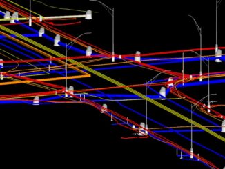
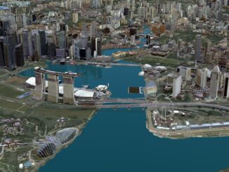
• facebook
  • Twitter
  • Linkedin
  • Youtube
  • Linkedin Group
  • Post a Job
  • Post an Ad
  • Post an Event
  • Post a Directory Listing
  • Post a Press Release
  • Media Kit
  • My Account
  • Login
GoGeomatics
  • MAGAZINE
    • BIM & GIS
    • Community
    • Conference news
    • Earth Observation
    • Education & Careers
    • GEOAI
    • Announcements
    • Reality Capture & Lidar
    • Science
    • Technology
    • Between the Poles
  • Directories
    • ASSOCIATION
    • INDUSTRY
    • EDUCATION
    • Open Data
  • EVENTS
    • GeoIgnite Events
    • Events Calendar
    • GoGeomatics Meetups
  • Services
    • Advertising
    • Marketing
    • Post a Job
    • Post an Ad
    • Post an Event
    • Post a Press Release
    • Post a Directory Listing
    • Media Kit
    • Web Design
  • Find a Job
  • Volunteer
    • Start a GoGeomatics Group
    • Editors & Writers Group
  • About Us
    • About Us
    • Contact Us
    • Frequently Asked Questions
  • Videos
HomeBetween the Poles – The Geoff Zeiss Archives3D data

3D data

3D data

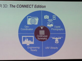
SPAR2016: Geo-coordination key to convergence of engineering and 3D technology

3 May 2016 Geoff Zeiss

We are seeing the convergence of engineering and architecture with 3D technology and this is enabling a full lifecycle perspective in designing and constructing infrastructure where we not only aim at better project delivery, but […]

3D data

GITA PNW: Geolocating dangerous underground utility intersections is big business

22 April 2016 Geoff Zeiss

At the 16th Annual GITA Pacific Northwest Conference at the Boeing Future of Flight Museum in Mukilteo WA, David Steiger gave a fascinating presentation about one of the major problems arising from our poor knowledge […]

3D data

Crossrail’s huge BIM+geospatial model targeted on operations and maintenance

4 April 2016 Geoff Zeiss

The UK Government as part of its building information modeling (BIM) initiative has said repeatedly that it expects the big payoff of a digital model, estimated at more than 40% savings, will be during operations and maintenance, […]

3D data

Using UAVs to create digital surface models for northern peatlands research

24 November 2015 Geoff Zeiss

I just attended a fascinating presentation with the unprepossessing title of “CCRS/NRC/McGill Scientists – TOPICS OF PEATLANDS AND THE MER BLEUE BOG.”  This was about a new project called MBASSS initiated by scientists from the Canada […]

3D data

One third of Be Inspired Awards involve mapping, managing, rehabbing and replacing aging infrastructure

18 November 2015 Geoff Zeiss

Worldwide there is increasing demand from building and infrastructure owners for service provision throughout the entire life cycle of a building or infrastructure. This represents a distinct break with the design/build tradition which has dominated […]

3D data

Modeling underground utilities in 3D reduces construction time and costs

17 November 2015 Geoff Zeiss

The location of existing underground utility infrastructure  is more often than not poorly known which creates significant risk for infrastructure and highway construction projects.  In a gas line construction project which Utility Mapping Services (UMS) […]

3D cadastre

Singapore’s national 3D model wins Be Inspired Award at YII2015

10 November 2015 Geoff Zeiss

At the the Year in Infrastructure conference in London the Singapore Land Authority (SLA) won the annual Be Inspired Award for Innovation in Government.  Comprising only 700 square kilometers for the entire nation, land is […]

3D data

Be Inspired Awards at Year in Infrastructure 2015: 3D modeling of underground utility infrastructure

1 November 2015 Geoff Zeiss

A highlight of the Year in Infrastructure conference in London are the Be Inspired Awards.  The annual Be Inspired Awards competition brings together infrastructure professionals and members of the media to share innovative practices in […]

Posts pagination

« 1 … 21 22 23 … 30 »

Events

Notice
There are no upcoming events.

View All Events

Services

  • Post a Job
  • Post an Ad
  • Post an Event
  • Post a Directory Listing
  • Post a Press Release
  • Media Kit
  • My Account
  • Login

Jobs

Post a Job
  • Volunteer Editorial Contributor – Be Part of Canada’s Geomatics Story
    Remote
  • Junior Geomatics Field Technician – Technical Surveys
    Montréal, QC
  • GIS Specialist
    Amherst, Nova Scotia
  • Precast Structural BIM Specialist
    Calgary, Alberta
View All Jobs
  • Directories
    • Associations Directory
    • Industry Directory
    • Education Programs
    • Open Data
  • Volunteer
    • Start a GoGeomatics Group
    • Editors & Writers Group
  • About Us
    • GoGeomatics Media Kit
    • Who We Are
    • Contact Us
    • FAQ’s
    • Advertising
    • Marketing
  • Subscribe
GoGeomatics
GoGeomatics is the largest and most popular communications hub promoting the Canadian geospatial community. The business was incorporated in 2011. GoGeomatics hosts over 100 fun, free, location technology networking events each year in cities across Canada.

© 2026 GoGeomatics

  • facebook
  • Twitter
  • Linkedin
  • Youtube
  • Linkedin Group