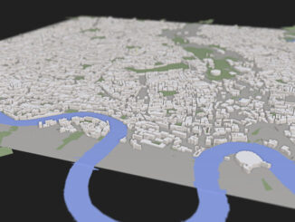
• facebook
  • Twitter
  • Linkedin
  • Youtube
  • Linkedin Group
  • Post a Job
  • Post an Ad
  • Post an Event
  • Post a Directory Listing
  • Post a Press Release
  • Media Kit
  • My Account
  • Login
GoGeomatics
  • MAGAZINE
    • BIM & GIS
    • Community
    • Conference news
    • Earth Observation
    • Education & Careers
    • GEOAI
    • Announcements
    • Reality Capture & Lidar
    • Science
    • Technology
    • Between the Poles
  • Directories
    • ASSOCIATION
    • INDUSTRY
    • EDUCATION
    • Open Data
  • EVENTS
    • GeoIgnite Events
    • Events Calendar
    • GoGeomatics Meetups
  • Services
    • Advertising
    • Marketing
    • Post a Job
    • Post an Ad
    • Post an Event
    • Post a Press Release
    • Post a Directory Listing
    • Media Kit
    • Web Design
  • Find a Job
  • Volunteer
    • Start a GoGeomatics Group
    • Editors & Writers Group
  • About Us
    • About Us
    • Contact Us
    • Frequently Asked Questions
  • Videos
HomeBetween the Poles – The Geoff Zeiss Archives3D data

3D data

3D data

Light-weight accurate 3D feature extraction from overlapping imagery

26 September 2013 Geoff Zeiss

I remember visiting a company in the business of digital aerial image acquisition, orthophotography, and stereo imagery. Using the stereo imagery they extracted 3D buildings and other objects to build 3D city models.  To do […]

3D data

SimCity with real data: modeling real cities in 3D in a Web environment

20 September 2013 Geoff Zeiss

At FOSS4G in Nottingham I was looking forward to hearing Peter Smart and Rob Hawkes talk about their ViziCities project which is intended to bring real world cities to life using open, big-data and open […]

3D data

The convergence of geospatial and BIM is gathering steam

28 August 2013 Geoff Zeiss

The August edition of Geospatial World Magazine is focussed on the theme of the integration of geopatial and building information modeling (BIM) in both its vertical and horizontal (BIM for Infrastructure) forms. Together the articles […]

No Picture
3D data

LIght-weight UAV-mounted laser scanning system announced

6 August 2013 Geoff Zeiss

Phoenix Aerial Systems has announced a UAV-mounted LiDAR platform weighing less than 10kg.  The new LiDAR platform called the “Phoenix AL-2” combines UAV, LiDAR and GNSS technology and is designed asa micro-mapping solution. The Phoenix […]

3D data

The future of national mapping agencies over the next 5-10 years

30 July 2013 Geoff Zeiss

Since Google Earth’s release in June 2005, national mapping agencies and other government organizations involved with geospatial data and technology have been reasessing their role.  At the Geospatial World Forum (GWF) in Amsterdam last year, […]

3D data

Widespread adoption of BIM by national governments

15 July 2013 Geoff Zeiss

A number of national governments around the world have mandated or are planning to mandate building information modeling (BIM). United States In 2003 in the United States the General Services Administration (GSA), through its Public […]

3D data

ESRI UC: 3D and other themes of this year’s conference

10 July 2013 Geoff Zeiss

According to Jack Dangermond who led the plenary sessions on the first day,  this year in San Diego 12000 people from 130 countries were in San Diego for the 33rd Esri International User Conference. I […]

3D data

Improving energy performance of buildings in an urban environment using 3D models

3 July 2013 Geoff Zeiss

The European Union has set itself agressive goals to reduce GHG emissions by 20%, increase renewables share of energy generation to 20%, and to reduce energy cinsumption by 20% by 2020.  The EU seems to […]

Posts pagination

« 1 … 27 28 29 30 »

Events

Notice
There are no upcoming events.

View All Events

Services

  • Post a Job
  • Post an Ad
  • Post an Event
  • Post a Directory Listing
  • Post a Press Release
  • Media Kit
  • My Account
  • Login

Jobs

Post a Job
  • Volunteer Editorial Contributor – Be Part of Canada’s Geomatics Story
    Remote
  • Junior Geomatics Field Technician – Technical Surveys
    Montréal, QC
  • GIS Specialist
    Amherst, Nova Scotia
  • Precast Structural BIM Specialist
    Calgary, Alberta
View All Jobs
  • Directories
    • Associations Directory
    • Industry Directory
    • Education Programs
    • Open Data
  • Volunteer
    • Start a GoGeomatics Group
    • Editors & Writers Group
  • About Us
    • GoGeomatics Media Kit
    • Who We Are
    • Contact Us
    • FAQ’s
    • Advertising
    • Marketing
  • Subscribe
GoGeomatics
GoGeomatics is the largest and most popular communications hub promoting the Canadian geospatial community. The business was incorporated in 2011. GoGeomatics hosts over 100 fun, free, location technology networking events each year in cities across Canada.

© 2026 GoGeomatics

  • facebook
  • Twitter
  • Linkedin
  • Youtube
  • Linkedin Group