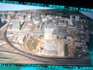
• facebook
  • Twitter
  • Linkedin
  • Youtube
  • Linkedin Group
  • Post a Job
  • Post an Ad
  • Post an Event
  • Post a Directory Listing
  • Post a Press Release
  • Media Kit
  • My Account
  • Login
GoGeomatics
  • MAGAZINE
    • BIM & GIS
    • Community
    • Conference news
    • Earth Observation
    • Education & Careers
    • GEOAI
    • Announcements
    • Reality Capture & Lidar
    • Science
    • Technology
    • Between the Poles
  • Directories
    • ASSOCIATION
    • INDUSTRY
    • EDUCATION
    • Open Data
  • EVENTS
    • GeoIgnite Events
    • Events Calendar
    • GoGeomatics Meetups
  • Services
    • Advertising
    • Marketing
    • Post a Job
    • Post an Ad
    • Post an Event
    • Post a Press Release
    • Post a Directory Listing
    • Media Kit
    • Web Design
  • Find a Job
  • Volunteer
    • Start a GoGeomatics Group
    • Editors & Writers Group
  • About Us
    • About Us
    • Contact Us
    • Frequently Asked Questions
  • Videos
HomeBetween the Poles – The Geoff Zeiss Archives3D data

3D data

3D data

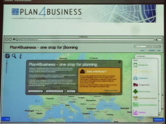
Platform for urban planning for infrastructure and other municipal services

3 July 2013 Geoff Zeiss

At the INSPIRE conference in Florence, Ewa Klien, Joachim Rix and Didier Vancutsen gave an overview of an interesting EU project called Plan4business.   Plan4business is designed to address the challenges faced by urban and […]

3D data

Adoption of 3D GIS by European agencies

2 July 2013 Geoff Zeiss

At the INSPIRE conference in Florence, Volker Walter presented the results of a EuroSDR Survey focussed on 3D data management in European national mapping (NMCAs) and cadastral agencies. 32 organizations were surveyed. 10 NMCAs 8 […]

3D data

Incorporating utilities into highway designs

1 July 2013 Geoff Zeiss

I have blogged numerous times about the challenge of accurately geolocating underground utilties. Most recently I blogged about the estimated ROI for investment in improving the geolocation and other information about underground utilities and the […]

3D data

Open source project for 3D urban models supporting crowdsourced data and smart services

27 June 2013 Geoff Zeiss

Yesterday at the INSPIRE conference, Federico Prandi gave a presentation about a fascinating open source project called i-SCOPE that involves developing 3D urban models that can be used to provide interactive smart services. The concept […]

3D data

Compatibility between CityGML and INSPIRE Buildings data

26 June 2013 Geoff Zeiss

The INSPIRE Data Specifications Annex III contains use cases encodings and a data model for Buildings.  The devlopment of this schema was strongly influenced by CityGML, an Open Geospatial Consortium (OGC) standard developed initially in […]

3D data

North American BIM adoption reached 71% in 2012

17 June 2013 Geoff Zeiss

Over the past five years the processes and technologies of building information modeling (BIM) have been transforming the construction industry.  First architects and to a lesser extent engineers, and now increasingly contractors are adopting BIM […]

3D data

Time required to create 3D city models dropping rapidly

5 June 2013 Geoff Zeiss

At the HxGN conference in Las Vegas today, there were some very interesting new technologies. Juergen Dold, President of Hexagon Geosystems, showed some images from a recent project in Zurich West, where the Zurich suburb […]

3D data

Hexacopter for inspecting transmission pylons and creating 3D models

5 June 2013 Geoff Zeiss

At the HxGN conference in Las Vegas today, there were some very interesting new technologies.  Juergen Dold, President of Hexagon Geosystems, announced a relationship between Leica Geosystems and Aibotix, a company that produces a hexacopter […]

Posts pagination

« 1 … 28 29 30 »

Events

Notice
There are no upcoming events.

View All Events

Services

  • Post a Job
  • Post an Ad
  • Post an Event
  • Post a Directory Listing
  • Post a Press Release
  • Media Kit
  • My Account
  • Login

Jobs

Post a Job
  • Volunteer Editorial Contributor – Be Part of Canada’s Geomatics Story
    Remote
  • Junior Geomatics Field Technician – Technical Surveys
    Montréal, QC
  • GIS Specialist
    Amherst, Nova Scotia
  • Precast Structural BIM Specialist
    Calgary, Alberta
View All Jobs
  • Directories
    • Associations Directory
    • Industry Directory
    • Education Programs
    • Open Data
  • Volunteer
    • Start a GoGeomatics Group
    • Editors & Writers Group
  • About Us
    • GoGeomatics Media Kit
    • Who We Are
    • Contact Us
    • FAQ’s
    • Advertising
    • Marketing
  • Subscribe
GoGeomatics
GoGeomatics is the largest and most popular communications hub promoting the Canadian geospatial community. The business was incorporated in 2011. GoGeomatics hosts over 100 fun, free, location technology networking events each year in cities across Canada.

© 2026 GoGeomatics

  • facebook
  • Twitter
  • Linkedin
  • Youtube
  • Linkedin Group