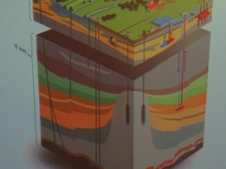
• facebook
  • Twitter
  • Linkedin
  • Youtube
  • Linkedin Group
  • Post a Job
  • Post an Ad
  • Post an Event
  • Post a Directory Listing
  • Post a Press Release
  • Media Kit
  • My Account
  • Login
GoGeomatics
  • MAGAZINE
    • BIM & GIS
    • Community
    • Conference news
    • Earth Observation
    • Education & Careers
    • GEOAI
    • Announcements
    • Reality Capture & Lidar
    • Science
    • Technology
    • Between the Poles
  • Directories
    • ASSOCIATION
    • INDUSTRY
    • EDUCATION
    • Open Data
  • EVENTS
    • GeoIgnite Events
    • Events Calendar
    • GoGeomatics Meetups
  • Services
    • Advertising
    • Marketing
    • Post a Job
    • Post an Ad
    • Post an Event
    • Post a Press Release
    • Post a Directory Listing
    • Media Kit
    • Web Design
  • Find a Job
  • Volunteer
    • Start a GoGeomatics Group
    • Editors & Writers Group
  • About Us
    • About Us
    • Contact Us
    • Frequently Asked Questions
  • Videos
HomeBetween the Poles – The Geoff Zeiss Archives3D data

3D data

3D data

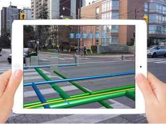
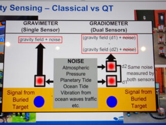
Applying quantum effects to detecting underground infrastructure

8 February 2021 Geoff Zeiss

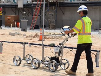
Many of the technologies for detecting underground utilities and other infrastructure involve shooting some type of signal, electromagnetic or acousic, into the ground and measuring the reflection off underground objects.  A major challenge for these […]

3D data

Applying inertial locating technology to mapping and condition assessment of large deep assets

26 January 2021 Geoff Zeiss

Knowing where things are underground has become important enough that in a number of jurisdictions around the world including the Netherlands, Singapore, and the U.K., initiatives are underway to create national digital twins which include […]

3D data

Inertial locating to accurately map LIVE underground gas distribution utilities is a game changer

20 January 2021 Geoff Zeiss

Inertial locating is an innovative technology that is used to accurately map underground pipe networks.  But to date the technology has required non-pressurized pipes.  Now a PHMSA-sponsored project has demonstrated that the technology can be […]

3D data

Colorado builds a high accuracy database of the location of underground assets in the public right of way

18 January 2021 Geoff Zeiss

New regulations were released January 14 by the Colorado Department of Transportation (CDoT) that mandates (1) the electronic submission of high accuracy plans showing the location of of underground infrastructure prior to commencing a construction […]

3D data

Should underground infrastructure location data be included in digital twins ?

7 December 2020 Geoff Zeiss

There are fundamental differences between above- and below-ground data which may limit the usefulness of underground data in digital twins.  For location data about the underground there are often data quality issues, legal restrictions on […]

3D data

Advanced geophysical remote sensing rapidly captures high resolution 3D data about subsurface geology

22 September 2020 Geoff Zeiss

Uncertain knowledge about what lies under the surface is a major cause of delays and budget overruns on construction projects.  It is well known that not knowing the location of utilities and other infrastructure is […]

3D data

Study shows augmented reality improves productivity of underground utility locators

4 August 2020 Geoff Zeiss

Mixed reality applications for visualizing underground utilities in 3D have been available from many companies for years, but have not been widely used. There are signs this is changing. For example, vGIS is an augmented […]

3D data

Innovative technology uses AM radio waves to detect underground infrastructure

21 July 2020 Geoff Zeiss

In the last few years there have been important advances in technology for detecting underground infrastructure including capturing ground penetrating radar (GPR) scans at highway speeds, combined GPR and LiDAR scanning for simultaneous above and […]

Posts pagination

« 1 … 4 5 6 … 30 »

Events

May 3
May 3 @ 8:00 am - May 6 @ 5:00 pm

GEOINT Symposium 2026

May 11
May 11 @ 8:00 am - May 13 @ 5:00 pm

GeoIgnite 2026

May 25
May 25 - May 28

National Surveyors’ Conference 2026

May 27
May 27 @ 8:00 am - May 29 @ 5:00 pm

The Canadian Cartographic Association AGM

Jun 1
June 1 - June 4

CAG/CARTO Annual Meeting 2026

View Calendar

View All Events

Services

  • Post a Job
  • Post an Ad
  • Post an Event
  • Post a Directory Listing
  • Post a Press Release
  • Media Kit
  • My Account
  • Login

Jobs

Post a Job
  • Volunteer Editorial Contributor – Be Part of Canada’s Geomatics Story
    Remote
  • Junior Geomatics Field Technician – Technical Surveys
    Montréal, QC
  • GIS Specialist
    Amherst, Nova Scotia
  • Precast Structural BIM Specialist
    Calgary, Alberta
View All Jobs
  • Directories
    • Associations Directory
    • Industry Directory
    • Education Programs
    • Open Data
  • Volunteer
    • Start a GoGeomatics Group
    • Editors & Writers Group
  • About Us
    • GoGeomatics Media Kit
    • Who We Are
    • Contact Us
    • FAQ’s
    • Advertising
    • Marketing
  • Subscribe
GoGeomatics
GoGeomatics is the largest and most popular communications hub promoting the Canadian geospatial community. The business was incorporated in 2011. GoGeomatics hosts over 100 fun, free, location technology networking events each year in cities across Canada.

© 2026 GoGeomatics

  • facebook
  • Twitter
  • Linkedin
  • Youtube
  • Linkedin Group