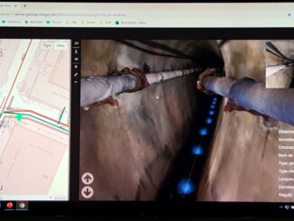
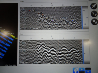
• facebook
  • Twitter
  • Linkedin
  • Youtube
  • Linkedin Group
  • Post a Job
  • Post an Ad
  • Post an Event
  • Post a Directory Listing
  • Post a Press Release
  • Media Kit
  • My Account
  • Login
GoGeomatics
  • MAGAZINE
    • BIM & GIS
    • Community
    • Conference news
    • Earth Observation
    • Education & Careers
    • GEOAI
    • Announcements
    • Reality Capture & Lidar
    • Science
    • Technology
    • Between the Poles
  • Directories
    • ASSOCIATION
    • INDUSTRY
    • EDUCATION
    • Open Data
  • EVENTS
    • GeoIgnite Events
    • Events Calendar
    • GoGeomatics Meetups
  • Services
    • Advertising
    • Marketing
    • Post a Job
    • Post an Ad
    • Post an Event
    • Post a Press Release
    • Post a Directory Listing
    • Media Kit
    • Web Design
  • Find a Job
  • Volunteer
    • Start a GoGeomatics Group
    • Editors & Writers Group
  • About Us
    • About Us
    • Contact Us
    • Frequently Asked Questions
  • Videos
HomeBetween the Poles – The Geoff Zeiss Archives3D data

3D data

3D data

Practical benefits of accurate mapping of underground utilities for construction projects

31 March 2020 Geoff Zeiss

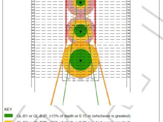
Government agencies and construction firms are recognizing the significant benefits of an accurate map of underground infrastructure for construction projects. Here we describe how accurate models of underground infrastructure bring practical benefits to construction projects. […]

3D data

Revision to PAS 128 standard for locating underground utilities available for public comment

3 March 2020 Geoff Zeiss

A revision to the PAS 128 2014 standard for locating underground utilities is available for public comment through March 16. PAS 128 defines a hierarchy of detection methods for detecting underground utilities in terms and […]

No Picture
3D data

New ASCE standard guideline for recording and exchanging utility infrastructure data is imminent

2 March 2020 Geoff Zeiss

The release of the new ASCE Standard Guideline for Recording and Exchanging Utility Infrastructure Data (also referred to as the utility as-built standard) developed under the auspices of the American Society of Civil Engineers (ASCE’s) […]

3D data

Automating scan-to-BIM for brownfield substations

6 February 2020 Geoff Zeiss

With about 55,000 substations in the U.S. and the average age of the transformers in these substations over 40 years old, many substations are going to be refurbished, retrofitted, extended or upgraded. Utilities are opting […]

3D data

Inertial mapping of underground pipe networks

10 December 2019 Geoff Zeiss

Currently best practices for recording the location of new underground infrastructure is to survey it after installation and before covering the trench. Appropriate survey tools are total stations, RTK, and LiDAR.  However, trenchless technology is […]

3D data

Burgeoning market for shareable subsurface geotechnical information

25 November 2019 Geoff Zeiss

Unforeseen ground conditions are a major cause of delays in construction projects.  This year, at Bentley Systems’ Year in Infrastructure Conference, Roger Chandler, Director of Geotechnical Information Management, announced OpenGround, a collection of applications for […]

3D data

Integrating 3D models and GIS for underground asset management

20 November 2019 Geoff Zeiss

I had the opportunity to attend the 1Spatial Smarter Data Smarter World conference in London.  A presentation by Seb Lessware, CTO of 1Spatial, of Realworld 4D for BIM and facilities management demonstrated an impressive integration […]

3D data

Breakthrough broadens adoption of GPR in 3D mapping of underground utilities

8 November 2019 Geoff Zeiss

Traditional output from a GPR scanner showing hyperbolas reflected from underground utilities The major inhibitor to broader use of ground penetrating radar for detecting the location of underground utilities is the difficulty in interpreting radar […]

Posts pagination

« 1 … 6 7 8 … 30 »

Events

Notice
There are no upcoming events.

View All Events

Services

  • Post a Job
  • Post an Ad
  • Post an Event
  • Post a Directory Listing
  • Post a Press Release
  • Media Kit
  • My Account
  • Login

Jobs

Post a Job
  • Volunteer Editorial Contributor – Be Part of Canada’s Geomatics Story
    Remote
  • Junior Geomatics Field Technician – Technical Surveys
    Montréal, QC
  • GIS Specialist
    Amherst, Nova Scotia
  • Precast Structural BIM Specialist
    Calgary, Alberta
View All Jobs
  • Directories
    • Associations Directory
    • Industry Directory
    • Education Programs
    • Open Data
  • Volunteer
    • Start a GoGeomatics Group
    • Editors & Writers Group
  • About Us
    • GoGeomatics Media Kit
    • Who We Are
    • Contact Us
    • FAQ’s
    • Advertising
    • Marketing
  • Subscribe
GoGeomatics
GoGeomatics is the largest and most popular communications hub promoting the Canadian geospatial community. The business was incorporated in 2011. GoGeomatics hosts over 100 fun, free, location technology networking events each year in cities across Canada.

© 2026 GoGeomatics

  • facebook
  • Twitter
  • Linkedin
  • Youtube
  • Linkedin Group