• facebook
  • Twitter
  • Linkedin
  • Youtube
  • Linkedin Group
  • Post a Job
  • Post an Ad
  • Post an Event
  • Post a Directory Listing
  • Post a Press Release
  • Media Kit
  • My Account
  • Login
GoGeomatics
  • MAGAZINE
    • BIM & GIS
    • Community
    • Conference news
    • Earth Observation
    • Education & Careers
    • GEOAI
    • Announcements
    • Reality Capture & Lidar
    • Science
    • Technology
    • Between the Poles
  • Directories
    • ASSOCIATION
    • INDUSTRY
    • EDUCATION
    • Open Data
  • EVENTS
    • GeoIgnite Events
    • Events Calendar
    • GoGeomatics Meetups
  • Services
    • Advertising
    • Marketing
    • Post a Job
    • Post an Ad
    • Post an Event
    • Post a Press Release
    • Post a Directory Listing
    • Media Kit
    • Web Design
  • Find a Job
  • Volunteer
    • Start a GoGeomatics Group
    • Editors & Writers Group
  • About Us
    • About Us
    • Contact Us
    • Frequently Asked Questions
  • Videos
HomeBetween the Poles – The Geoff Zeiss Archives3D Visualization

3D Visualization

3D Visualization

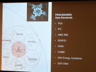
RICS BIM: Extending benefits of BIM to building operations and maintenance

15 February 2013 Geoff Zeiss

At the RICS BIM National Conference 2013, Deborah Rowland, Head of Facilities Management, Government Property Unit, Cabinet Office in the UK Government outlined the Government’s motivation and plans for a program to improve the post […]

3D Visualization

Geodesign Summit: Creating 3D BIM models for the entire LA community college system

28 January 2013 Geoff Zeiss

Michael Rendler is the Director of e7 Architectural Studio which is a non-profit organization working with the Los Angeles Community College District (LACCD).  Its goals are to assist in designing environmentally sound and sustainable additions […]

3D Visualization

Geodesign Summit: Carl Steinitz on the early days of geodesign and organizing education for geodesign

24 January 2013 Geoff Zeiss

Last night Carl Steinitz, Professor of Landscape Architecture and Planning at the Graduate School of Design at Harvard, gave two presentations.  The first addressed the queston of how to organize education in geosdesign and was […]

3D Visualization

Moving from 2D design to 3D design standards in electricity distribution

17 January 2013 Geoff Zeiss

The Utilities Standards Forum (USF) is an organization representing about 50 Ontario electricity distribution companies.  Its goal is collaboratively to define standards for its members to reduce duplication of effort.   The USF has developed design […]

3D Visualization

Cesium open source WebGL virtual globe and mapping Javascript library

16 November 2012 Geoff Zeiss

Earlier this week on an Eclipse Foundation Locationtech teleconference, Matt Ford of Cesium provided an overview and demonstration of the features of Cesium.  You can watch the video here. Cesium is an open source virtual […]

3D Visualization

What to expect in the OpenLayers 3

16 November 2012 Geoff Zeiss

Last week on an Eclipse Foundation Locationtech teleconference, Tim Schaub of OpenGeo outlined the plans for the next version of OpenLayers.   You can watch the video and contribute to the effort  here. OpenLayers2 was released […]

3D Visualization

Simplified conceptual design with BIM and built-in energy and carbon performance analysis

22 August 2012 Geoff Zeiss

Project Vasari is a simplified design tool for creating conceptual building designs with integrated analysis for energy and carbon.  One of its big differentiators from products like Sketchup is that it is intended to fit […]

3D Visualization

Augmented reality technology preview

10 August 2012 Geoff Zeiss

There is a new technology preview at Autodesk Labs, Augmented Reality for Showcase.  Augmented reality makes it possible to overlay information (graphics, text, video, sound) on to a live video feed of the real-world in […]

Posts pagination

« 1 … 9 10 11 … 16 »

Events

Notice
There are no upcoming events.

View All Events

Services

  • Post a Job
  • Post an Ad
  • Post an Event
  • Post a Directory Listing
  • Post a Press Release
  • Media Kit
  • My Account
  • Login

Jobs

Post a Job
  • Volunteer Editorial Contributor – Be Part of Canada’s Geomatics Story
    Remote
  • Junior Geomatics Field Technician – Technical Surveys
    Montréal, QC
  • GIS Specialist
    Amherst, Nova Scotia
  • Precast Structural BIM Specialist
    Calgary, Alberta
View All Jobs
  • Directories
    • Associations Directory
    • Industry Directory
    • Education Programs
    • Open Data
  • Volunteer
    • Start a GoGeomatics Group
    • Editors & Writers Group
  • About Us
    • GoGeomatics Media Kit
    • Who We Are
    • Contact Us
    • FAQ’s
    • Advertising
    • Marketing
  • Subscribe
GoGeomatics
GoGeomatics is the largest and most popular communications hub promoting the Canadian geospatial community. The business was incorporated in 2011. GoGeomatics hosts over 100 fun, free, location technology networking events each year in cities across Canada.

© 2026 GoGeomatics

  • facebook
  • Twitter
  • Linkedin
  • Youtube
  • Linkedin Group