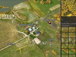
• facebook
  • Twitter
  • Linkedin
  • Youtube
  • Linkedin Group
  • Post a Job
  • Post an Ad
  • Post an Event
  • Post a Directory Listing
  • Post a Press Release
  • Media Kit
  • My Account
  • Login
GoGeomatics
  • MAGAZINE
    • BIM & GIS
    • Community
    • Conference news
    • Earth Observation
    • Education & Careers
    • GEOAI
    • Announcements
    • Reality Capture & Lidar
    • Science
    • Technology
    • Between the Poles
  • Directories
    • ASSOCIATION
    • INDUSTRY
    • EDUCATION
    • Open Data
  • EVENTS
    • GeoIgnite Events
    • Events Calendar
    • GoGeomatics Meetups
  • Services
    • Advertising
    • Marketing
    • Post a Job
    • Post an Ad
    • Post an Event
    • Post a Press Release
    • Post a Directory Listing
    • Media Kit
    • Web Design
  • Find a Job
  • Volunteer
    • Start a GoGeomatics Group
    • Editors & Writers Group
  • About Us
    • About Us
    • Contact Us
    • Frequently Asked Questions
  • Videos
HomeBetween the Poles – The Geoff Zeiss Archives3D Visualization

3D Visualization

3D data

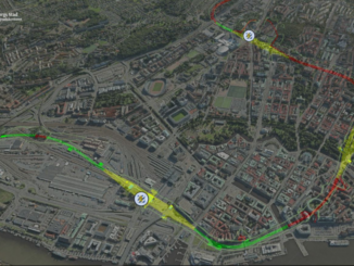
Bentley’s digital twin capabilities for cities includes underground infrastructure

23 October 2018 Geoff Zeiss

Proposed West Link tunnel under central Gothenburg More and more cities are recognizing the tremendous benefits that a digital twin provides to its planners, private architects and engineers striving for compliance with city ordinances and […]

3D data

Documenting construction projects with a consumer 360° camera

3 October 2018 Geoff Zeiss

Many see handheld scanners as revolutionizing the construction sector.  Portable and handheld laser scanners offer millimeter accuracy and can be used for engineering purposes.  Cameras with less precision are being used for rapidly documenting a […]

3D data

Mapping indoors with a smart phone

24 August 2018 Geoff Zeiss

At the Spar 3D Expo and Conference 2016 in Houston, Texas, Avideh Zakhor from the University of California Berkeley showed remarkable products from her startup Indoor Reality.  I blogged previously about the technology when it […]

No Picture
3D Visualization

British guidelines for BIM targeting 33% savings in TOTEX to become international ISO standards

23 June 2018 Geoff Zeiss

The BS 1192 suite of guidelines and best practices developed under the auspices of the BSI, the national standards body of the UK, are designed to help the UK construction industry adopt BIM Level 2 […]

3D data

Bringing the games immersive experience to BIM and the AEC industry

13 June 2018 Geoff Zeiss

The games industry is ahead of everyone in creating a 2D or 3D interactive experience with high fidelity graphics deployable on desktops, laptops, or mobile phones. Unity and Unreal engines are the leaders in providing […]

3D data

Generating real-time 3D reconstructions using a UAV equipped with a digital camera linked to a laptop

12 June 2018 Geoff Zeiss

Drones are very efficient at capturing a large volume of data that often requires hours of post-processing in the cloud to create 3D reconstructions that can be used for 3D visualization and other applications.  In […]

3D data

An open source web-based platform for integrating BIM and 3D geospatial

1 December 2017 Geoff Zeiss

BIM+geospatial integration is being driven by a trend toward infrastructure construction projects that require maintenance and/or operations during an extended period post-construction.  At the GEO|Design+BIM conference in Amsterdam, Sanghee Shin, CEO of Gaia3D Inc., gave […]

3D data

Perceptality: new laser scanning applications potentially transforming construction

26 June 2017 Geoff Zeiss

At HxGNLive Juergen Dold, President of Hexagon Geosystems which is responsible for the Leica Geosystems brand, gave a talk about perception and reality.  Perception is how we see the world, but perceptions are subjective and […]

Posts pagination

« 1 2 3 … 16 »

Events

Feb 19
February 19 - February 22

SKI Conference Canada 2026

Feb 23
7:00 pm - 9:00 pm

Toronto GoGeomatics Networking Social – February 23, 2026

Feb 24
All day

Digital Leadership Day Federal

Feb 24
February 24 - February 26

Government Innovation Week – Federal

Feb 24
5:30 pm - 7:30 pm

GoGeomatics Kelowna February Social

View Calendar

View All Events

Services

  • Post a Job
  • Post an Ad
  • Post an Event
  • Post a Directory Listing
  • Post a Press Release
  • Media Kit
  • My Account
  • Login

Jobs

Post a Job
  • Volunteer Editorial Contributor – Be Part of Canada’s Geomatics Story
    Remote
  • Junior Geomatics Field Technician – Technical Surveys
    Montréal, QC
  • GIS Specialist
    Amherst, Nova Scotia
  • Precast Structural BIM Specialist
    Calgary, Alberta
View All Jobs
  • Directories
    • Associations Directory
    • Industry Directory
    • Education Programs
    • Open Data
  • Volunteer
    • Start a GoGeomatics Group
    • Editors & Writers Group
  • About Us
    • GoGeomatics Media Kit
    • Who We Are
    • Contact Us
    • FAQ’s
    • Advertising
    • Marketing
  • Subscribe
GoGeomatics
GoGeomatics is the largest and most popular communications hub promoting the Canadian geospatial community. The business was incorporated in 2011. GoGeomatics hosts over 100 fun, free, location technology networking events each year in cities across Canada.

© 2026 GoGeomatics

  • facebook
  • Twitter
  • Linkedin
  • Youtube
  • Linkedin Group