• facebook
  • Twitter
  • Linkedin
  • Youtube
  • Linkedin Group
  • Post a Job
  • Post an Ad
  • Post an Event
  • Post a Directory Listing
  • Post a Press Release
  • Media Kit
  • My Account
  • Login
GoGeomatics
  • MAGAZINE
    • BIM & GIS
    • Community
    • Conference news
    • Earth Observation
    • Education & Careers
    • GEOAI
    • Announcements
    • Reality Capture & Lidar
    • Science
    • Technology
    • Between the Poles
  • Directories
    • ASSOCIATION
    • INDUSTRY
    • EDUCATION
    • Open Data
  • EVENTS
    • GeoIgnite Events
    • Events Calendar
    • GoGeomatics Meetups
  • Services
    • Advertising
    • Marketing
    • Post a Job
    • Post an Ad
    • Post an Event
    • Post a Press Release
    • Post a Directory Listing
    • Media Kit
    • Web Design
  • Find a Job
  • Volunteer
    • Start a GoGeomatics Group
    • Editors & Writers Group
  • About Us
    • About Us
    • Contact Us
    • Frequently Asked Questions
  • Videos
HomeBetween the Poles – The Geoff Zeiss Archives3D Visualization

3D Visualization

3D data

Democratizing 3D scanning to non-surveyor professionals

20 April 2017 Geoff Zeiss

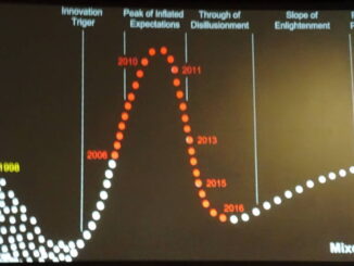
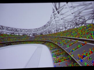
At the SPAR3D 2017 conference, Burkhard Boeckem, CTO of Hexagon Geosystems, gave a vision of the future of 3D technologies developed by technology firms such as Hexagon.  Among the well-known brands that form Hexagon Geosystems […]

3D Visualization

Mixed reality in the construction industry is becoming a reality

13 April 2017 Geoff Zeiss

At the SPAR3D 2017 conference in Houston, I had the distinct feeling that we are on the cusp of an important inflection point where technology has evolved to the point that it is going to […]

3D data

Handheld 3D scanners rapidly approaching consumer pricing

11 April 2017 Geoff Zeiss

I have just spent an incredible three days in Houston at the SPAR3D 2017 conference.  There is so much going on right now in the 3D world with several key technologies just coming to fruition […]

3D data

Bentley Systems and AGI support open source 3D geospatial

26 February 2017 Geoff Zeiss

Back in 2006 Autodesk was the leading sponsor supporting the formation of the Open Geospatial Foundation (OSGeo) in order to open geospatial technology to a wider audience.  Now Bentley Systems has joined with AGI to […]

No Picture
3D data

Developing a national 3D strategy in the Netherlands

8 December 2016 Geoff Zeiss

At the GeoBIM Building and Infrastructure Conference in Amsterdam Rob van de Velde and Friso Penninga of Geonovum presented an overview of what has been achieved to date with respect to 3D data and technology […]

3D data

Development of an open spatially-enabled BIM query language

25 October 2016 Geoff Zeiss

Introduction Building Information Models are comprehensive digital representations of buildings which include 3D geometry and associated data. They are widely used for designing, engineering, and constructing buildings (vertical BIM) and infrastructure (horizontal BIM). Owners are […]

3D data

Crowd behaviour modeling with BIM

6 October 2016 Geoff Zeiss

I spent a fascinating day at the CanBIM Regional Session & Technology Exhibition in Toronto.  I was very impressed by how much things relating to BIM have progressed in Canada, which has generally lagged the […]

3D data

BIM adoption in the UK surpasses 50%

3 August 2016 Geoff Zeiss

The UK Government’s goal for construction industry is to reduce the CAPEX for public construction projects.  To reach its goal for the construction industry the UK Government has undertaken several initiatives, one of which is […]

Posts pagination

« 1 2 3 4 … 16 »

Events

Feb 24
5:30 pm - 7:30 pm

Kelowna Mural Map – User Feedback & Networking Social

Feb 24
6:30 pm - 8:30 pm

February Ottawa GoGeomatics Meetup

Feb 25
All day

Government Cybersecurity Showcase Federal 2026

Mar 1
March 1 - March 4

PDAC Convention 2026

Mar 10
March 10 - March 13

2026 ABCLS Conference and 121st Annual General Meeting

View Calendar

View All Events

Services

  • Post a Job
  • Post an Ad
  • Post an Event
  • Post a Directory Listing
  • Post a Press Release
  • Media Kit
  • My Account
  • Login

Jobs

Post a Job
  • Volunteer Editorial Contributor – Be Part of Canada’s Geomatics Story
    Remote
  • Junior Geomatics Field Technician – Technical Surveys
    Montréal, QC
  • GIS Specialist
    Amherst, Nova Scotia
  • Precast Structural BIM Specialist
    Calgary, Alberta
View All Jobs
  • Directories
    • Associations Directory
    • Industry Directory
    • Education Programs
    • Open Data
  • Volunteer
    • Start a GoGeomatics Group
    • Editors & Writers Group
  • About Us
    • GoGeomatics Media Kit
    • Who We Are
    • Contact Us
    • FAQ’s
    • Advertising
    • Marketing
  • Subscribe
GoGeomatics
GoGeomatics is the largest and most popular communications hub promoting the Canadian geospatial community. The business was incorporated in 2011. GoGeomatics hosts over 100 fun, free, location technology networking events each year in cities across Canada.

© 2026 GoGeomatics

  • facebook
  • Twitter
  • Linkedin
  • Youtube
  • Linkedin Group