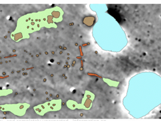
• facebook
  • Twitter
  • Linkedin
  • Youtube
  • Linkedin Group
  • Post a Job
  • Post an Ad
  • Post an Event
  • Post a Directory Listing
  • Post a Press Release
  • Media Kit
  • My Account
  • Login
GoGeomatics
  • MAGAZINE
    • BIM & GIS
    • Community
    • Conference news
    • Earth Observation
    • Education & Careers
    • GEOAI
    • Announcements
    • Reality Capture & Lidar
    • Science
    • Technology
    • Between the Poles
  • Directories
    • ASSOCIATION
    • INDUSTRY
    • EDUCATION
    • Open Data
  • EVENTS
    • GeoIgnite Events
    • Events Calendar
    • GoGeomatics Meetups
  • Services
    • Advertising
    • Marketing
    • Post a Job
    • Post an Ad
    • Post an Event
    • Post a Press Release
    • Post a Directory Listing
    • Media Kit
    • Web Design
  • Find a Job
  • Volunteer
    • Start a GoGeomatics Group
    • Editors & Writers Group
  • About Us
    • About Us
    • Contact Us
    • Frequently Asked Questions
  • Videos
HomeBetween the Poles – The Geoff Zeiss Archives3D Visualization

3D Visualization

3D data

Subsurface sensing technologies map a superhenge at Stonehenge

10 September 2014 Geoff Zeiss

The objective of the remarkable four year Stonehenge project was to create a detailed archaeological map of Stonehenge and its surroundings based on a synthesis of remote sensing and subterrainean geophysical data. The  result is […]

3D data

Urban planning working group announced by the Open Geospatial Consortium

21 August 2014 Geoff Zeiss

An Urban Planning Domain Working Group (DWG) has been chartered to define the role for Open Geospatial Consortium (OGC) standards within the urban planning discipline.  The DWG offers an open forum for the discussion and […]

3D Visualization

OGC’s new Urban Planning group releases draft charter

17 July 2014 Geoff Zeiss

An Urban Planning Domain Working Group (DWG) is being chartered to define the role for OGC standards and related activities related to urban planning.  It is also intended to provide an open forum for the […]

3D data

Increasing penetration of open source geospatial software in the global utility GIS market

8 July 2014 Geoff Zeiss

Improving process efficiency (also here, here, here and here) is a major challenge for the utility industry.  Geospatial technology is a key technology that helps utilities improve the efficiency of their business processes (such as designing-constructing-maintaining and operating their […]

No Picture
3D data

Standards for the convergence of BIM, 3D and geospatial

23 June 2014 Geoff Zeiss

At Geospatial World Forum 2014 in Geneva this year Leif Granhom, Senior Vice President at Tekla Finland gave an insightful presentation about the integration of building information modeling (BIM) and geospatial information.  An important part of […]

3D Visualization

Building energy performance optimization using BIM and an integrated project delivery approach

29 April 2014 Geoff Zeiss

As part of a seminar series supported by the Algonquin College Office of Applied  Research & Innovation and the Canada Green Building Council Ottawa Chapter, Jean Carriere, President and Building Performance Technologist at Trailloop gave […]

3D data

Construction industry moving to maximize geospatial content

28 April 2014 Geoff Zeiss

At the SPAR International conference Kevin Gilson, Director of the Design Visualization group at  Parsons Brinckerhoff (PB) gave an insightful presentation on integrated 3D modeling and visualization for large transportation projects with some examples from […]

3D data

Handheld scanners set to revolutionize construction

16 April 2014 Geoff Zeiss

At the SPAR International Conference today Kirk Knorr from Burns & McDonnell and Gregory Lawes of point3D gave a presentation about their experience using a handheld scanner from DotProduct LLC.  This is a professional device […]

Posts pagination

« 1 … 5 6 7 … 16 »

Events

Sep 16
September 16 - September 17

Join ALL IN 2026, Montreal, Canada

Oct 26
October 26 - October 28

Canada’s National Geomatics Expo 2026

Oct 27
October 27 - October 29

Rendez-vous Géomatique 2026

View Calendar

View All Events

Services

  • Post a Job
  • Post an Ad
  • Post an Event
  • Post a Directory Listing
  • Post a Press Release
  • Media Kit
  • My Account
  • Login

Jobs

Post a Job
  • Volunteer Editorial Contributor – Be Part of Canada’s Geomatics Story
    Remote
  • Junior Geomatics Field Technician – Technical Surveys
    Montréal, QC
  • GIS Specialist
    Amherst, Nova Scotia
  • Precast Structural BIM Specialist
    Calgary, Alberta
View All Jobs
  • Directories
    • Associations Directory
    • Industry Directory
    • Education Programs
    • Open Data
  • Volunteer
    • Start a GoGeomatics Group
    • Editors & Writers Group
  • About Us
    • GoGeomatics Media Kit
    • Who We Are
    • Contact Us
    • FAQ’s
    • Advertising
    • Marketing
  • Subscribe
GoGeomatics
GoGeomatics is the largest and most popular communications hub promoting the Canadian geospatial community. The business was incorporated in 2011. GoGeomatics hosts over 100 fun, free, location technology networking events each year in cities across Canada.

© 2026 GoGeomatics

  • facebook
  • Twitter
  • Linkedin
  • Youtube
  • Linkedin Group