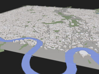
• facebook
  • Twitter
  • Linkedin
  • Youtube
  • Linkedin Group
  • Post a Job
  • Post an Ad
  • Post an Event
  • Post a Directory Listing
  • Post a Press Release
  • Media Kit
  • My Account
  • Login
GoGeomatics
  • MAGAZINE
    • BIM & GIS
    • Community
    • Conference news
    • Earth Observation
    • Education & Careers
    • GEOAI
    • Announcements
    • Reality Capture & Lidar
    • Science
    • Technology
    • Between the Poles
  • Directories
    • ASSOCIATION
    • INDUSTRY
    • EDUCATION
    • Open Data
  • EVENTS
    • GeoIgnite Events
    • Events Calendar
    • GoGeomatics Meetups
  • Services
    • Advertising
    • Marketing
    • Post a Job
    • Post an Ad
    • Post an Event
    • Post a Press Release
    • Post a Directory Listing
    • Media Kit
    • Web Design
  • Find a Job
  • Volunteer
    • Start a GoGeomatics Group
    • Editors & Writers Group
  • About Us
    • About Us
    • Contact Us
    • Frequently Asked Questions
  • Videos
HomeBetween the Poles – The Geoff Zeiss Archives3D Visualization

3D Visualization

3D Visualization

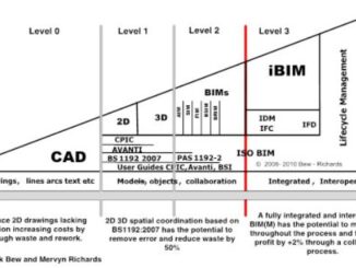
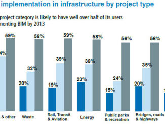
Convergence of BIM, geospatial, imagery and 3D enables new vertical industry solutions

17 October 2013 Geoff Zeiss

Earlier this year I was invited to give a keynote at the South Africa Surveying and Mapping Indaba.  PositionIT has just published the paper Geospatial Information Technology Enables Vertical Industry Solutions based on my keynote. […]

3D data

SimCity with real data: modeling real cities in 3D in a Web environment

20 September 2013 Geoff Zeiss

At FOSS4G in Nottingham I was looking forward to hearing Peter Smart and Rob Hawkes talk about their ViziCities project which is intended to bring real world cities to life using open, big-data and open […]

3D Visualization

Construction projects using BIM projected to reach £27 billion by 2016 in the UK

9 September 2013 Geoff Zeiss

The 2013 BIM Report by construction industry marketing consultancy Competitive Advantage presents research on the rate of implementation, the types of BIM objects required and the support expected from manufacturers in the UK. The report […]

3D data

The convergence of geospatial and BIM is gathering steam

28 August 2013 Geoff Zeiss

The August edition of Geospatial World Magazine is focussed on the theme of the integration of geopatial and building information modeling (BIM) in both its vertical and horizontal (BIM for Infrastructure) forms. Together the articles […]

3D Visualization

ESRI UC: Geodesign projects in 3D

11 July 2013 Geoff Zeiss

At the ESRI User Conference Eric Wittner, a 3D Technology Evangelist, at ESRI presented some Geodesign projects that involve 3D that ESRI has worked on.  This was very interesting because it provides a practical perspective […]

3D data

ESRI UC: 3D and other themes of this year’s conference

10 July 2013 Geoff Zeiss

According to Jack Dangermond who led the plenary sessions on the first day,  this year in San Diego 12000 people from 130 countries were in San Diego for the 33rd Esri International User Conference. I […]

3D data

Platform for urban planning for infrastructure and other municipal services

3 July 2013 Geoff Zeiss

At the INSPIRE conference in Florence, Ewa Klien, Joachim Rix and Didier Vancutsen gave an overview of an interesting EU project called Plan4business.   Plan4business is designed to address the challenges faced by urban and […]

3D Visualization

Adoption of horizontal BIM, heavy BIM, VDC, civil information modeling, BIM on its side, and BIM for infrastructure

11 June 2013 Geoff Zeiss

Horizontal BIM, heavy BIM, VDC, civil information modeling, BIM on its side, or BIM for infrastructure are terms used in the construction industry for  the application of model-based technologies and processes to non-building projects. This […]

Posts pagination

« 1 … 7 8 9 … 16 »

Events

Notice
There are no upcoming events.

View All Events

Services

  • Post a Job
  • Post an Ad
  • Post an Event
  • Post a Directory Listing
  • Post a Press Release
  • Media Kit
  • My Account
  • Login

Jobs

Post a Job
  • Volunteer Editorial Contributor – Be Part of Canada’s Geomatics Story
    Remote
  • Junior Geomatics Field Technician – Technical Surveys
    Montréal, QC
  • GIS Specialist
    Amherst, Nova Scotia
  • Precast Structural BIM Specialist
    Calgary, Alberta
View All Jobs
  • Directories
    • Associations Directory
    • Industry Directory
    • Education Programs
    • Open Data
  • Volunteer
    • Start a GoGeomatics Group
    • Editors & Writers Group
  • About Us
    • GoGeomatics Media Kit
    • Who We Are
    • Contact Us
    • FAQ’s
    • Advertising
    • Marketing
  • Subscribe
GoGeomatics
GoGeomatics is the largest and most popular communications hub promoting the Canadian geospatial community. The business was incorporated in 2011. GoGeomatics hosts over 100 fun, free, location technology networking events each year in cities across Canada.

© 2026 GoGeomatics

  • facebook
  • Twitter
  • Linkedin
  • Youtube
  • Linkedin Group