• facebook
  • Twitter
  • Linkedin
  • Youtube
  • Linkedin Group
  • Post a Job
  • Post an Ad
  • Post an Event
  • Post a Directory Listing
  • Post a Press Release
  • Media Kit
  • My Account
  • Login
GoGeomatics
  • MAGAZINE
    • BIM & GIS
    • Community
    • Conference news
    • Earth Observation
    • Education & Careers
    • GEOAI
    • Announcements
    • Reality Capture & Lidar
    • Science
    • Technology
    • Between the Poles
  • Directories
    • ASSOCIATION
    • INDUSTRY
    • EDUCATION
    • Open Data
  • EVENTS
    • GeoIgnite Events
    • Events Calendar
    • GoGeomatics Meetups
  • Services
    • Advertising
    • Marketing
    • Post a Job
    • Post an Ad
    • Post an Event
    • Post a Press Release
    • Post a Directory Listing
    • Media Kit
    • Web Design
  • Find a Job
  • Volunteer
    • Start a GoGeomatics Group
    • Editors & Writers Group
  • About Us
    • About Us
    • Contact Us
    • Frequently Asked Questions
  • Videos
HomeBetween the Poles – The Geoff Zeiss ArchivesAccess to Spatial Data

Access to Spatial Data

Access to Spatial Data

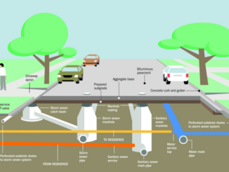
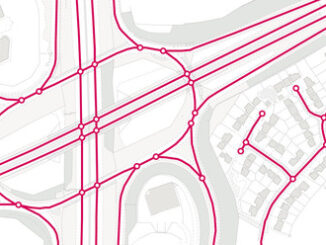
Visualizing underground infrastructure for multiple utilities on a single map

3 May 2022 Geoff Zeiss

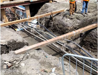
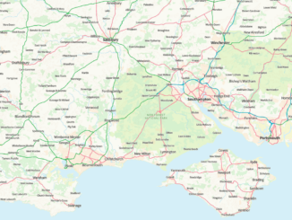
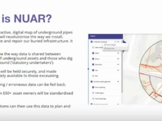
The National Underground Asset Register (NUAR) is intended to be a comprehensive digital map of all underground pipes and cables owned and operated by 650 asset owners in England, Wales and Northern Ireland. When deployed […]

Access to Spatial Data

Federal initiatives in Canada to improve subsurface locating to reduce damage during construction

18 February 2020 Geoff Zeiss

A remarkable initiative within the Federal government in Canada to improve mapping of Federally regulated underground infrastructure and infrastructure on Federal lands was presented at the Ontario Regional Common Ground Alliance (ORCGA) 2020 Symposium in […]

Access to Spatial Data

Accelerating progress in open spatial data infrastructure at the municipal level in Canada

20 October 2019 Geoff Zeiss

At the SDI Summit in Quebec City Gordon Plunkett offered an interesting perspective on the penetration of open spatial data infrastructure (SDI) at the municipal level in Canada.  Local governments are traditionally responsible for local […]

3D data

Is it ethical to bury dangerous infrastructure in the public right-of-way without accurate maps ?

10 September 2019 Geoff Zeiss

This is a readable version of a video that I submitted to the EthicalGEO site. Without accurate maps of where underground infrastructure is located, every construction project has the potential to become a disaster site. […]

Access to Spatial Data

Severely restricted access to critical infrastructure information in the U.S.

27 August 2019 Geoff Zeiss

The Critical Infrastructure Information Act of 2002 of the U.S. Congress provides a mechanism for severely restricting access to proprietary critical infrastructure information voluntarily shared by network operators with the federal government.  It prevents consumers […]

3D cadastre

US 3D elevation project as a model for a national infrastructure map

24 September 2018 Geoff Zeiss

A number of years ago an initiative was funded under the ARRA economic stimulus package to initiate what was then called LiDAR for the Nation.  This has resulted in a USGS initiative called 3D Elevation […]

Access to Spatial Data

Ordnance Survey releases vector basemap optimized for national overview to street level

24 July 2018 Geoff Zeiss

The Ordnance Survey has just released OS Open Zoomstack for public feedback. OS Open Zoomstack is very impressive because it is a vector basemap optimized for different scales – from a national overview to street […]

Access to Spatial Data

UK Mastermap to be made freely available

13 June 2018 Geoff Zeiss

As part of the Prime Minister’s London Tech Week roundtable, the UK Government has announced that key parts of the OS MasterMap will be made openly available for the public and businesses to use. OS […]

Posts pagination

1 2 … 16 »

Events

Feb 16
February 16 @ 8:00 am - February 18 @ 5:00 pm

GeoWeek 2026

Feb 17
5:00 pm - 8:00 pm

Victoria GoGeomatics February Mappy Hour

Feb 17
6:00 pm - 8:00 pm

Calgary GoGeomatics February Social

Feb 18
6:30 pm - 8:30 pm

Vancouver GoGeomatics Meetup – February 2026

Feb 19
February 19 - February 22

Spatial Knowledge and Information Canada 2026

View Calendar

View All Events

Services

  • Post a Job
  • Post an Ad
  • Post an Event
  • Post a Directory Listing
  • Post a Press Release
  • Media Kit
  • My Account
  • Login

Jobs

Post a Job
  • Volunteer Editorial Contributor – Be Part of Canada’s Geomatics Story
    Remote
  • Junior Geomatics Field Technician – Technical Surveys
    Montréal, QC
  • GIS Specialist
    Amherst, Nova Scotia
  • Precast Structural BIM Specialist
    Calgary, Alberta
View All Jobs
  • Directories
    • Associations Directory
    • Industry Directory
    • Education Programs
    • Open Data
  • Volunteer
    • Start a GoGeomatics Group
    • Editors & Writers Group
  • About Us
    • GoGeomatics Media Kit
    • Who We Are
    • Contact Us
    • FAQ’s
    • Advertising
    • Marketing
  • Subscribe
GoGeomatics
GoGeomatics is the largest and most popular communications hub promoting the Canadian geospatial community. The business was incorporated in 2011. GoGeomatics hosts over 100 fun, free, location technology networking events each year in cities across Canada.

© 2026 GoGeomatics

  • facebook
  • Twitter
  • Linkedin
  • Youtube
  • Linkedin Group