• facebook
  • Twitter
  • Linkedin
  • Youtube
  • Linkedin Group
  • Post a Job
  • Post an Ad
  • Post an Event
  • Post a Directory Listing
  • Post a Press Release
  • Media Kit
  • My Account
  • Login
GoGeomatics
  • MAGAZINE
    • BIM & GIS
    • Community
    • Conference news
    • Earth Observation
    • Education & Careers
    • GEOAI
    • Announcements
    • Reality Capture & Lidar
    • Science
    • Technology
    • Between the Poles
  • Directories
    • ASSOCIATION
    • INDUSTRY
    • EDUCATION
    • Open Data
  • EVENTS
    • GeoIgnite Events
    • Events Calendar
    • GoGeomatics Meetups
  • Services
    • Advertising
    • Marketing
    • Post a Job
    • Post an Ad
    • Post an Event
    • Post a Press Release
    • Post a Directory Listing
    • Media Kit
    • Web Design
  • Find a Job
  • Volunteer
    • Start a GoGeomatics Group
    • Editors & Writers Group
  • About Us
    • About Us
    • Contact Us
    • Frequently Asked Questions
  • Videos
HomeBetween the Poles – The Geoff Zeiss ArchivesAccess to Spatial Data

Access to Spatial Data

Access to Spatial Data

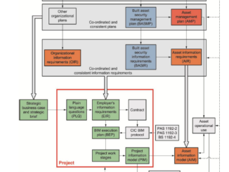
Importance of implementing cybersecurity for engineering projects using BIM

12 June 2017 Geoff Zeiss

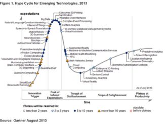
At GeoBusiness 2017 in London, Hugh Boyes, a Cyber Security specialist outlined some of the security risks of digital engineering and the importance of cybersecurity for engineering projects.  BIM models, floorplans and 3D LiDAR scans […]

Access to Spatial Data

U.S. congressional bill to restrict access to open geospatial information

17 March 2017 Geoff Zeiss

A bill has been introduced in the U.S. House of Representatives that specifically targets open access to geospatial information.  It intends to do this by nullifying a regulation under the Civil Rights Act of 1968 […]

3D data

Bentley Systems and AGI support open source 3D geospatial

26 February 2017 Geoff Zeiss

Back in 2006 Autodesk was the leading sponsor supporting the formation of the Open Geospatial Foundation (OSGeo) in order to open geospatial technology to a wider audience.  Now Bentley Systems has joined with AGI to […]

Access to Spatial Data

Future of Utilities: Utility asset management will be based on shared geospatial platform

5 July 2016 Geoff Zeiss

Currently geospatial data and technology are used tactically by electric power utilities for many purposes including outage management, vegetation management, disaster management, renewable energy facility siting, universal electrification planning, asset management, and energy density mapping, […]

No Picture
Access to Spatial Data

India proposes restricting access to geospatial data

22 June 2016 Geoff Zeiss

Some countries including Indonesia have passed legislation regulating geospatial data.   The intention appears to be to ensure a certain level of quality in geospatial data provided by private data providers to the public.  For example, […]

Access to Spatial Data

Citizen geodata science an emerging big data trend

6 June 2016 Geoff Zeiss

Gartner’s latest hype cycle identifies a new trend “citizen data science” that has important implications for the geospatial sector. At the recent Canadian Institute of Geomatics (CIG) Ottawa Branch Workshop on Big Data: What is […]

Access to Spatial Data

GeoBuiz 2016: High volume geospatial imagery processing requires new architecture

29 April 2016 Geoff Zeiss

DigitalGlobe owns and operates a constellation of commercial earth observation satellites.  The latest is Worldview-3 which is capable of about 30 cm precision.  Digital Globe’s satellites collect 3,000,000 square kilometers of Earth imagery every day, […]

Access to Spatial Data

Year in Infrastructure 2015: Open electric power network documentation in the UK

6 November 2015 Geoff Zeiss

At the Year in Infrastructure conference in London in the Utilities breakout session I was invited to participate in an industry panel discussion on “Repair, Rehab, and Replacement of Aging Infrastructure“.  The two panelists I […]

Posts pagination

« 1 2 3 4 … 16 »

Events

Feb 24
5:30 pm - 7:30 pm

Kelowna Mural Map – User Feedback & Networking Social

Feb 24
6:30 pm - 8:30 pm

February Ottawa GoGeomatics Meetup

Feb 25
All day

Government Cybersecurity Showcase Federal 2026

Mar 1
March 1 - March 4

PDAC Convention 2026

Mar 10
March 10 - March 13

2026 ABCLS Conference and 121st Annual General Meeting

View Calendar

View All Events

Services

  • Post a Job
  • Post an Ad
  • Post an Event
  • Post a Directory Listing
  • Post a Press Release
  • Media Kit
  • My Account
  • Login

Jobs

Post a Job
  • Volunteer Editorial Contributor – Be Part of Canada’s Geomatics Story
    Remote
  • Junior Geomatics Field Technician – Technical Surveys
    Montréal, QC
  • GIS Specialist
    Amherst, Nova Scotia
  • Precast Structural BIM Specialist
    Calgary, Alberta
View All Jobs
  • Directories
    • Associations Directory
    • Industry Directory
    • Education Programs
    • Open Data
  • Volunteer
    • Start a GoGeomatics Group
    • Editors & Writers Group
  • About Us
    • GoGeomatics Media Kit
    • Who We Are
    • Contact Us
    • FAQ’s
    • Advertising
    • Marketing
  • Subscribe
GoGeomatics
GoGeomatics is the largest and most popular communications hub promoting the Canadian geospatial community. The business was incorporated in 2011. GoGeomatics hosts over 100 fun, free, location technology networking events each year in cities across Canada.

© 2026 GoGeomatics

  • facebook
  • Twitter
  • Linkedin
  • Youtube
  • Linkedin Group