• facebook
  • Twitter
  • Linkedin
  • Youtube
  • Linkedin Group
  • Post a Job
  • Post an Ad
  • Post an Event
  • Post a Directory Listing
  • Post a Press Release
  • Media Kit
  • My Account
  • Login
GoGeomatics
  • MAGAZINE
    • BIM & GIS
    • Community
    • Conference news
    • Earth Observation
    • Education & Careers
    • GEOAI
    • Announcements
    • Reality Capture & Lidar
    • Science
    • Technology
    • Between the Poles
  • Directories
    • ASSOCIATION
    • INDUSTRY
    • EDUCATION
    • Open Data
  • EVENTS
    • GeoIgnite Events
    • Events Calendar
    • GoGeomatics Meetups
  • Services
    • Advertising
    • Marketing
    • Post a Job
    • Post an Ad
    • Post an Event
    • Post a Press Release
    • Post a Directory Listing
    • Media Kit
    • Web Design
  • Find a Job
  • Volunteer
    • Start a GoGeomatics Group
    • Editors & Writers Group
  • About Us
    • About Us
    • Contact Us
    • Frequently Asked Questions
  • Videos
HomeBetween the Poles – The Geoff Zeiss ArchivesAccess to Spatial Data

Access to Spatial Data

3D cadastre

Benefits of a 3D land and property information system for sustainable urbanization

17 May 2012 Geoff Zeiss

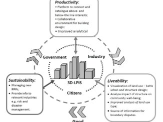
At the GSDI 13 conference in Quebec City, Serene Ho and Abbas Rajabifard from Australia delivered a paper on the benefits of a 3D land and property information system (3D-LPIS) to an increasingly urbanized society.  […]

Access to Spatial Data

Towards a global licensing framework for geospatial data

17 May 2012 Geoff Zeiss

In 2007 I listened to an exceptional presentation at a Spatial Sciences Institute Biennial International Conference in Hobart, Tasmania given by Tim Barker and Neale Hooper, of the Queensland Treasury, part of the government of […]

Access to Spatial Data

Canada’s spatial data infrastructure (SDI): past, present and future

15 May 2012 Geoff Zeiss

Prashant Shukle, Director General of the Mapping Information Branch (MIB), Natural Resources Canada,  gave an overview of the Canadian experience in developing a national spatial data infrastructure (SDI).  He echoed the Minister of Natural Resource’s […]

Access to Spatial Data

Data creation is not information use

15 May 2012 Geoff Zeiss

At the Global Geospatial Conference 2012 in Québec City, Ed Parsons of Google argued in favour of web access to micro data including geospatial.  Google’s goal is to organize the world’s information, of which geospatial […]

Access to Spatial Data

Canadian Minister of Natural Resources says geomatics is essential to economic development

15 May 2012 Geoff Zeiss

At the Global Geospatial Conference 2012 in Québec City, the Minister of Natural Resources of Canada, said that geomatics is strategic for economic development in Canada.  Geomatics annually contributes $2.8 billion to the Canadian economy, […]

Access to Spatial Data

Geospatial World Forum: Unlocking quality asset information at Heathrow

9 May 2012 Geoff Zeiss

Airports are like cities.  They have all the infrastructure that cities have plus some.  Heathrow is the busiest airport in Europe with on average 181,000 passengers passing through it each day.  Heathrow has 13 different […]

Access to Spatial Data

Accessing Bing maps in an AutoCAD environment

4 May 2012 GoGeomatics Canada

On the Autodesk Labs site, you can find a new free technology preview, Project Basejump, that enables AutoCAD Map 3D and AutoCAD Civil 3D users to access Microsoft Bing web mapping service (WMS) maps including […]

Access to Spatial Data

Open geo data in the Netherlands since January 2012

29 April 2012 Geoff Zeiss

Some time ago I blogged about freely available government geospatial data in various parts of the world, but mentioned that in the Netherlands only some data was freely avaiilable.  At the recent Geospatial World Forum […]

Posts pagination

« 1 … 6 7 8 … 16 »

Events

Notice
There are no upcoming events.

View All Events

Services

  • Post a Job
  • Post an Ad
  • Post an Event
  • Post a Directory Listing
  • Post a Press Release
  • Media Kit
  • My Account
  • Login

Jobs

Post a Job
  • Volunteer Editorial Contributor – Be Part of Canada’s Geomatics Story
    Remote
  • Junior Geomatics Field Technician – Technical Surveys
    Montréal, QC
  • GIS Specialist
    Amherst, Nova Scotia
  • Precast Structural BIM Specialist
    Calgary, Alberta
View All Jobs
  • Directories
    • Associations Directory
    • Industry Directory
    • Education Programs
    • Open Data
  • Volunteer
    • Start a GoGeomatics Group
    • Editors & Writers Group
  • About Us
    • GoGeomatics Media Kit
    • Who We Are
    • Contact Us
    • FAQ’s
    • Advertising
    • Marketing
  • Subscribe
GoGeomatics
GoGeomatics is the largest and most popular communications hub promoting the Canadian geospatial community. The business was incorporated in 2011. GoGeomatics hosts over 100 fun, free, location technology networking events each year in cities across Canada.

© 2026 GoGeomatics

  • facebook
  • Twitter
  • Linkedin
  • Youtube
  • Linkedin Group