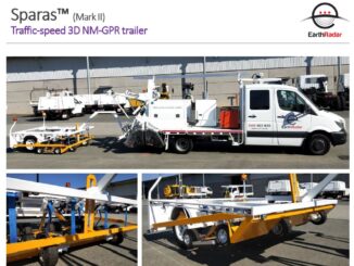
• facebook
  • Twitter
  • Linkedin
  • Youtube
  • Linkedin Group
  • Post a Job
  • Post an Ad
  • Post an Event
  • Post a Directory Listing
  • Post a Press Release
  • Media Kit
  • My Account
  • Login
GoGeomatics
  • MAGAZINE
    • BIM & GIS
    • Community
    • Conference news
    • Earth Observation
    • Education & Careers
    • GEOAI
    • Announcements
    • Reality Capture & Lidar
    • Science
    • Technology
    • Between the Poles
  • Directories
    • ASSOCIATION
    • INDUSTRY
    • EDUCATION
    • Open Data
  • EVENTS
    • GeoIgnite Events
    • Events Calendar
    • GoGeomatics Meetups
  • Services
    • Advertising
    • Marketing
    • Post a Job
    • Post an Ad
    • Post an Event
    • Post a Press Release
    • Post a Directory Listing
    • Media Kit
    • Web Design
  • Find a Job
  • Volunteer
    • Start a GoGeomatics Group
    • Editors & Writers Group
  • About Us
    • About Us
    • Contact Us
    • Frequently Asked Questions
  • Videos
HomeBetween the Poles – The Geoff Zeiss ArchivesAirports

Airports

3D data

Novel radar technology enables ground penetrating radar scanning at roadway speeds

31 July 2019 Geoff Zeiss

Underground utility damage during construction is a major safety problem and drag on economies in many countries.  The technologies that are currently considered best practices for detecting underground utilities have been used for decades and […]

Access to Spatial Data

First step toward developing a national infrastructure map to enable smart investments

7 May 2018 Geoff Zeiss

In its 2017 Infrastructure Report Card, the American Society of Civil Engineers (ASCE) assigned an overall grade of D+ to U.S. infrastructure. Addressing the problem of bringing national infrastructure up to a standard where it […]

Airports

2017 ASCE Infrastructure Scorecard reveals slight improvement

9 March 2017 Geoff Zeiss

The 2017 ASCE Infrastructure Scorecard has been released this morning.  Grades for seven categories of infrastructure – Hazardous Waste, Inland Waterways, Levees, Ports, Rail, Schools, and Wastewater – improved slightly. The grades for three categories […]

3D Visualization

SPAR 2013: BIM + GIS based facilities management at Denver International Airport

17 April 2013 Geoff Zeiss

At SPAR 2013 Dennis Rodriguez, Project Manager at Denver International Airport (DIA), and Daniel Stonecipher of Immersiv, gave a fascinating presentation on how they combined a BIM-based design and construction process with GIS  to create […]

Access to Spatial Data

Geospatial World Forum: Unlocking quality asset information at Heathrow

9 May 2012 Geoff Zeiss

Airports are like cities.  They have all the infrastructure that cities have plus some.  Heathrow is the busiest airport in Europe with on average 181,000 passengers passing through it each day.  Heathrow has 13 different […]

Events

Apr 13
5:30 pm - 7:30 pm

GoGeomatics Regina Meetup

Apr 15
6:30 am - 8:30 pm

GoGeomatics Vancouver Meetup – April Networking Social

Apr 21
6:00 pm - 8:00 pm

Calgary GoGeomatics April Social

Apr 22
April 22 - April 23

11th Annual Digitalization & AI in Energy Canada Conference

Apr 27
April 27 - April 30

Welcome to the Canadian Hydrographic Conference 2026

View Calendar

View All Events

Services

  • Post a Job
  • Post an Ad
  • Post an Event
  • Post a Directory Listing
  • Post a Press Release
  • Media Kit
  • My Account
  • Login

Jobs

Post a Job
  • Geospatial Analytical Technician / Technicien, analyses géospatiales; technicienne, analyses géospatiales
    Peterborough
  • GIS Technologist II
    Fernie, B.C.
  • GIS I TECHNOLOGIST
    Fernie, B.C.
  • Building Science and Restoration CAD/BIM Technologist
    Vancouver
View All Jobs
  • Directories
    • Associations Directory
    • Industry Directory
    • Education Programs
    • Open Data
  • Volunteer
    • Start a GoGeomatics Group
    • Editors & Writers Group
  • About Us
    • GoGeomatics Media Kit
    • Who We Are
    • Contact Us
    • FAQ’s
    • Advertising
    • Marketing
  • Subscribe
GoGeomatics
GoGeomatics is the largest and most popular communications hub promoting the Canadian geospatial community. The business was incorporated in 2011. GoGeomatics hosts over 100 fun, free, location technology networking events each year in cities across Canada.

© 2026 GoGeomatics

  • facebook
  • Twitter
  • Linkedin
  • Youtube
  • Linkedin Group