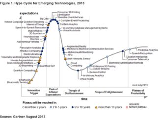
• facebook
  • Twitter
  • Linkedin
  • Youtube
  • Linkedin Group
  • Post a Job
  • Post an Ad
  • Post an Event
  • Post a Directory Listing
  • Post a Press Release
  • Media Kit
  • My Account
  • Login
GoGeomatics
  • MAGAZINE
    • BIM & GIS
    • Community
    • Conference news
    • Earth Observation
    • Education & Careers
    • GEOAI
    • Announcements
    • Reality Capture & Lidar
    • Science
    • Technology
    • Between the Poles
  • Directories
    • ASSOCIATION
    • INDUSTRY
    • EDUCATION
    • Open Data
  • EVENTS
    • GeoIgnite Events
    • Events Calendar
    • GoGeomatics Meetups
  • Services
    • Advertising
    • Marketing
    • Post a Job
    • Post an Ad
    • Post an Event
    • Post a Press Release
    • Post a Directory Listing
    • Media Kit
    • Web Design
  • Find a Job
  • Volunteer
    • Start a GoGeomatics Group
    • Editors & Writers Group
  • About Us
    • About Us
    • Contact Us
    • Frequently Asked Questions
  • Videos
HomeBetween the Poles – The Geoff Zeiss ArchivesAnalytics

Analytics

Analytics

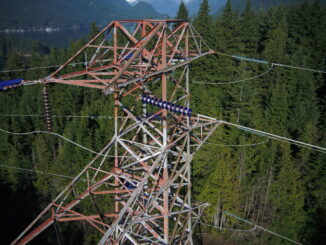
Automated drone systems improve power line inspections and reduce costs

5 May 2020 Geoff Zeiss

Transmission line inspections are mandatory in North America. Traditionally helicopters are used for these inspections, but with helicopters the risk of accidents is significant and helicopters are costly to maintain and operate.  Drone inspections dramatically […]

Analytics

Is legacy GIS failing network infrastructure operating companies ?

24 July 2019 Geoff Zeiss

I thought it would be worthwhile to include here an expanded version of my contribution to a webinar that IQGeo presented last week with a provocative title that I think goes right to the nub […]

3D data

High resolution satellite imagery helps innovative electric utility optimize vegetation management

5 February 2018 Geoff Zeiss

Vegetation is a significant source of outages for many utilities. In some regions from one quarter to one half of all outages can be ascribed to vegetation.  Vegetation encroachment initiated the massive North American northeastern […]

3D data

Are point clouds going away ?

19 April 2017 Geoff Zeiss

At the SPAR3D 2017 conference in Houston, one of the interesting questions posed to a panel comprised of Greg Bentley (CEO of Bentley), Burkhard Boeckem (CTO of Hexagon Geosystems), and Shabtay Negry (Senior VP at […]

Analytics

Utility industry vendors urged to adopt data model standard

17 February 2017 Geoff Zeiss

Software comes and goes, but a utility’s data model persists. A shared electric power data model enables electric power utilities to move away from incompatible point solutions toward tightly integrated solutions which are essential for […]

Analytics

U.S. governors urge Trump to support renewable energy and grid modernization

16 February 2017 Geoff Zeiss

The Governors’ Wind and Solar Energy Coalition (GWSC), representing 20 U.S. state governors, both Democratic and Republican, sent a letter to President Trump presenting the benefits of renewable energy, arguing for a Federal commitment to […]

Access to Spatial Data

Citizen geodata science an emerging big data trend

6 June 2016 Geoff Zeiss

Gartner’s latest hype cycle identifies a new trend “citizen data science” that has important implications for the geospatial sector. At the recent Canadian Institute of Geomatics (CIG) Ottawa Branch Workshop on Big Data: What is […]

Analytics

GeoBuiz 2016: Geospatial and consumer devices, reality modeling, big data and analytics

2 May 2016 Geoff Zeiss

Reality modeling In the future, the deliverables at the end of a construction project will not only include the completed building itself, but also a digital “reality model” of the structure.  The digital model will […]

Posts pagination

1 2 … 6 »

Events

Mar 30
7:00 pm - 9:30 pm

Toronto GoGeomatics March Networking Social

Mar 31
March 31 - April 1

Geo Connect Asia 2026

Mar 31
8:00 am - 6:00 pm

Kootenays GoGeomatics Meetup in Nelson BC

Mar 31
6:30 pm - 8:30 pm

GoGeomatics Ottawa Networking Social – March 2026

Apr 13
5:30 pm - 7:30 pm

GoGeomatics Regina Meetup

View Calendar

View All Events

Services

  • Post a Job
  • Post an Ad
  • Post an Event
  • Post a Directory Listing
  • Post a Press Release
  • Media Kit
  • My Account
  • Login

Jobs

Post a Job
  • GIS Technologist II
    Fernie, B.C.
  • GIS I TECHNOLOGIST
    Fernie, B.C.
  • Building Science and Restoration CAD/BIM Technologist
    Vancouver
  • Digital Services Coordinator (BIM)
    Toronto
View All Jobs
  • Directories
    • Associations Directory
    • Industry Directory
    • Education Programs
    • Open Data
  • Volunteer
    • Start a GoGeomatics Group
    • Editors & Writers Group
  • About Us
    • GoGeomatics Media Kit
    • Who We Are
    • Contact Us
    • FAQ’s
    • Advertising
    • Marketing
  • Subscribe
GoGeomatics
GoGeomatics is the largest and most popular communications hub promoting the Canadian geospatial community. The business was incorporated in 2011. GoGeomatics hosts over 100 fun, free, location technology networking events each year in cities across Canada.

© 2026 GoGeomatics

  • facebook
  • Twitter
  • Linkedin
  • Youtube
  • Linkedin Group