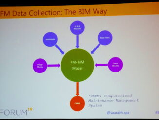
• facebook
  • Twitter
  • Linkedin
  • Youtube
  • Linkedin Group
  • Post a Job
  • Post an Ad
  • Post an Event
  • Post a Directory Listing
  • Post a Press Release
  • Media Kit
  • My Account
  • Login
GoGeomatics
  • MAGAZINE
    • BIM & GIS
    • Community
    • Conference news
    • Earth Observation
    • Education & Careers
    • GEOAI
    • Announcements
    • Reality Capture & Lidar
    • Science
    • Technology
    • Between the Poles
  • Directories
    • ASSOCIATION
    • INDUSTRY
    • EDUCATION
    • Open Data
  • EVENTS
    • GeoIgnite Events
    • Events Calendar
    • GoGeomatics Meetups
  • Services
    • Advertising
    • Marketing
    • Post a Job
    • Post an Ad
    • Post an Event
    • Post a Press Release
    • Post a Directory Listing
    • Media Kit
    • Web Design
  • Find a Job
  • Volunteer
    • Start a GoGeomatics Group
    • Editors & Writers Group
  • About Us
    • About Us
    • Contact Us
    • Frequently Asked Questions
  • Videos
HomeBetween the Poles – The Geoff Zeiss ArchivesAsset management

Asset management

3D data

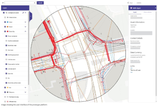
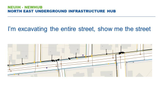
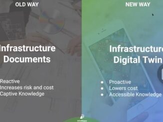
An infrastructure digital twin provides a dynamic environment for managing underground assets of a multi-utility campus

6 July 2022 Geoff Zeiss

For organizations managing a campus such as educational facilities, healthcare facilities, commercial real estate, utilities, and municipalities managing public works, storm sewer systems, and parks which are characterized by having many different utilities and and […]

Asset management

Pilot project to create national map of UK energy infrastructure launched

25 October 2021 Geoff Zeiss

A proof-of-concept project to develop a National Energy Systems Map (NESM) has been launched by the UK’s electricity and gas networks. The pilot project will give customers information about energy network assets, where those assets […]

Asset management

UK’s bottom-up/top-down approach to creating a voluntary National Underground Asset Registry

6 July 2021 Geoff Zeiss

Many jurisidictions are recognizing the human and economic cost of not knowing the location of underground utilities and other infrastructure and are looking at legislative, regulatory, technological, business practice and other measures to find ways […]

Asset management

UK BIM adoption survey reveals facilities/asset management trails other disciplines

5 July 2021 Geoff Zeiss

The UK Government as part of its building information modeling (BIM) initiative has said repeatedly that it expects the big payoff of a digital model will be during operations and maintenance, which typically represents 80% […]

Asset management

Elements for improving underground utility mapping to reduce risk of damage during construction

16 December 2019 Geoff Zeiss

Without accurate maps of underground infrastructure, every construction project has the potential to become a disaster site. Unlike the aviation industry where reliable data is collected and is accessible to investigators to prevent disasters from […]

3D printing

BIM and geospatial for facilities management is penetrating construction

18 September 2019 Geoff Zeiss

Typically at BIMForum events, the audience is composed of architects, engineers and construction contractors, with the odd owner, but rarely facilities management (FM) folks. At this year’s BIMForum 2019 conference in St Louis several talks […]

Asset management

Geospatial Commission announces UK registry of underground utilities

29 April 2019 Geoff Zeiss

Every construction project devotes significant efforts to locating underground utilities prior to and during construction. But this information is rarely shared and the location of underground infrastructure is recaptured over and over again.  To begin […]

Asset management

Bringing reliable near real-time GIS within reach of every utility

12 March 2019 Geoff Zeiss

Workflows for ensuring utility GIS quality are fundamentally broken and have been for decades.  Integrating CAD and GIS into an efficient workflow has been a challenge and it has simply not been a priority in […]

Posts pagination

1 2 … 7 »

Events

Feb 16
February 16 @ 8:00 am - February 18 @ 5:00 pm

GeoWeek 2026

Feb 17
5:00 pm - 8:00 pm

Victoria GoGeomatics February Mappy Hour

Feb 17
6:00 pm - 8:00 pm

Calgary GoGeomatics February Social

Feb 18
6:30 pm - 8:30 pm

Vancouver GoGeomatics Meetup – February 2026

Feb 19
February 19 - February 22

Spatial Knowledge and Information Canada 2026

View Calendar

View All Events

Services

  • Post a Job
  • Post an Ad
  • Post an Event
  • Post a Directory Listing
  • Post a Press Release
  • Media Kit
  • My Account
  • Login

Jobs

Post a Job
  • Volunteer Editorial Contributor – Be Part of Canada’s Geomatics Story
    Remote
  • Junior Geomatics Field Technician – Technical Surveys
    Montréal, QC
  • GIS Specialist
    Amherst, Nova Scotia
  • Precast Structural BIM Specialist
    Calgary, Alberta
View All Jobs
  • Directories
    • Associations Directory
    • Industry Directory
    • Education Programs
    • Open Data
  • Volunteer
    • Start a GoGeomatics Group
    • Editors & Writers Group
  • About Us
    • GoGeomatics Media Kit
    • Who We Are
    • Contact Us
    • FAQ’s
    • Advertising
    • Marketing
  • Subscribe
GoGeomatics
GoGeomatics is the largest and most popular communications hub promoting the Canadian geospatial community. The business was incorporated in 2011. GoGeomatics hosts over 100 fun, free, location technology networking events each year in cities across Canada.

© 2026 GoGeomatics

  • facebook
  • Twitter
  • Linkedin
  • Youtube
  • Linkedin Group