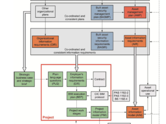
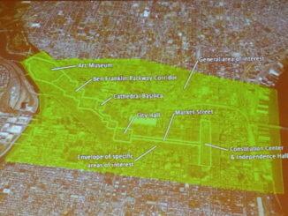
• facebook
  • Twitter
  • Linkedin
  • Youtube
  • Linkedin Group
  • Post a Job
  • Post an Ad
  • Post an Event
  • Post a Directory Listing
  • Post a Press Release
  • Media Kit
  • My Account
  • Login
GoGeomatics
  • MAGAZINE
    • BIM & GIS
    • Community
    • Conference news
    • Earth Observation
    • Education & Careers
    • GEOAI
    • Announcements
    • Reality Capture & Lidar
    • Science
    • Technology
    • Between the Poles
  • Directories
    • ASSOCIATION
    • INDUSTRY
    • EDUCATION
    • Open Data
  • EVENTS
    • GeoIgnite Events
    • Events Calendar
    • GoGeomatics Meetups
  • Services
    • Advertising
    • Marketing
    • Post a Job
    • Post an Ad
    • Post an Event
    • Post a Press Release
    • Post a Directory Listing
    • Media Kit
    • Web Design
  • Find a Job
  • Volunteer
    • Start a GoGeomatics Group
    • Editors & Writers Group
  • About Us
    • About Us
    • Contact Us
    • Frequently Asked Questions
  • Videos
HomeBetween the Poles – The Geoff Zeiss ArchivesAsset management

Asset management

Asset management

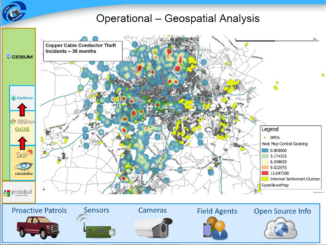
Open source geospatial application reduces copper cable theft by 70%

7 August 2017 Geoff Zeiss

A highlight of the SA Geotech conference in Johannesburg was a presentation by Ryno Goosen of Suritec Geospatial.  Ryno, who was awarded the Best Paper prize at SA Geotec, gave a fascinating presentation about how he […]

Access to Spatial Data

Importance of implementing cybersecurity for engineering projects using BIM

12 June 2017 Geoff Zeiss

At GeoBusiness 2017 in London, Hugh Boyes, a Cyber Security specialist outlined some of the security risks of digital engineering and the importance of cybersecurity for engineering projects.  BIM models, floorplans and 3D LiDAR scans […]

3D data

Simplifying the integration of reality capture and asset management

24 May 2017 Geoff Zeiss

The construction industry in the UK, as in many of the world’s advanced economies, suffers from low productivity compared to other industries, a situation which hasn’t improved in 25 years according to Simon Rawlinson of […]

Analytics

Utility industry vendors urged to adopt data model standard

17 February 2017 Geoff Zeiss

Software comes and goes, but a utility’s data model persists. A shared electric power data model enables electric power utilities to move away from incompatible point solutions toward tightly integrated solutions which are essential for […]

Access to Spatial Data

Future of Utilities: Utility asset management will be based on shared geospatial platform

5 July 2016 Geoff Zeiss

Currently geospatial data and technology are used tactically by electric power utilities for many purposes including outage management, vegetation management, disaster management, renewable energy facility siting, universal electrification planning, asset management, and energy density mapping, […]

3D data

SPAR2016: Greg Bentley on geo-coordination,mapping underground infrastructure, and information flow in construction

10 May 2016 Geoff Zeiss

At the Spar 3D Expo and Conference in Houston Greg Bentley gave a keynote in the morning in which he especially focused on reality modeling and how this technology had been applied to model in […]

3D data

Spar 3D: 3D mapping the inside of multi-story buildings with a backpack

5 May 2016 Geoff Zeiss

At the Spar 3D Expo and Conference in Houston The Woodlands, Texas, Avideh Zakhor from the University of California Berkeley was onsite with some remarkable products from her new startup Indoor Reality.  I blogged previously […]

3D data

SPAR2016: Geo-coordination key to convergence of engineering and 3D technology

3 May 2016 Geoff Zeiss

We are seeing the convergence of engineering and architecture with 3D technology and this is enabling a full lifecycle perspective in designing and constructing infrastructure where we not only aim at better project delivery, but […]

Posts pagination

« 1 2 3 4 … 7 »

Events

Feb 24
5:30 pm - 7:30 pm

Kelowna Mural Map – User Feedback & Networking Social

Feb 24
6:30 pm - 8:30 pm

February Ottawa GoGeomatics Meetup

Feb 25
All day

Government Cybersecurity Showcase Federal 2026

Mar 1
March 1 - March 4

PDAC Convention 2026

Mar 10
March 10 - March 13

2026 ABCLS Conference and 121st Annual General Meeting

View Calendar

View All Events

Services

  • Post a Job
  • Post an Ad
  • Post an Event
  • Post a Directory Listing
  • Post a Press Release
  • Media Kit
  • My Account
  • Login

Jobs

Post a Job
  • Volunteer Editorial Contributor – Be Part of Canada’s Geomatics Story
    Remote
  • Junior Geomatics Field Technician – Technical Surveys
    Montréal, QC
  • GIS Specialist
    Amherst, Nova Scotia
  • Precast Structural BIM Specialist
    Calgary, Alberta
View All Jobs
  • Directories
    • Associations Directory
    • Industry Directory
    • Education Programs
    • Open Data
  • Volunteer
    • Start a GoGeomatics Group
    • Editors & Writers Group
  • About Us
    • GoGeomatics Media Kit
    • Who We Are
    • Contact Us
    • FAQ’s
    • Advertising
    • Marketing
  • Subscribe
GoGeomatics
GoGeomatics is the largest and most popular communications hub promoting the Canadian geospatial community. The business was incorporated in 2011. GoGeomatics hosts over 100 fun, free, location technology networking events each year in cities across Canada.

© 2026 GoGeomatics

  • facebook
  • Twitter
  • Linkedin
  • Youtube
  • Linkedin Group