• facebook
  • Twitter
  • Linkedin
  • Youtube
  • Linkedin Group
  • Post a Job
  • Post an Ad
  • Post an Event
  • Post a Directory Listing
  • Post a Press Release
  • Media Kit
  • My Account
  • Login
GoGeomatics
  • MAGAZINE
    • BIM & GIS
    • Community
    • Conference news
    • Earth Observation
    • Education & Careers
    • GEOAI
    • Announcements
    • Reality Capture & Lidar
    • Science
    • Technology
    • Between the Poles
  • Directories
    • ASSOCIATION
    • INDUSTRY
    • EDUCATION
    • Open Data
  • EVENTS
    • GeoIgnite Events
    • Events Calendar
    • GoGeomatics Meetups
  • Services
    • Advertising
    • Marketing
    • Post a Job
    • Post an Ad
    • Post an Event
    • Post a Press Release
    • Post a Directory Listing
    • Media Kit
    • Web Design
  • Find a Job
  • Volunteer
    • Start a GoGeomatics Group
    • Editors & Writers Group
  • About Us
    • About Us
    • Contact Us
    • Frequently Asked Questions
  • Videos
HomeBetween the Poles – The Geoff Zeiss ArchivesAsset management

Asset management

Asset management

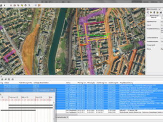
Coordinating public infrastructure construction projects in Bern saved SFR 7 million in first year

19 May 2014 Geoff Zeiss

While in Switzerland for Geospatial World Forum 2014 I had the opportunity to spend some time with Dr. Martin Huber of Condesys Consulting who is responsible for the online web-based system Koordination im öffentlichen Raum […]

Aging workforce

Bridging the generation gap for spatially-enabled asset management

16 April 2014 Geoff Zeiss

I’ve blogged many times about the aging workforce challenge facing many industries.  At the SPAR International conference Wayne Rodieck of Anadarko Petroleum outlined what this means to the oil and gas industry and how he […]

Asset management

Australian Government sponsors report on the economic benefits of global positioning systems

2 April 2014 Geoff Zeiss

The Australian Government has prepared reports on the economic benefits of global navigation satellite systems (GNSS) including specific sectors of the Australian economy.  The studies were conducted by ACIL Allen.   To provide some context for […]

Asset management

Major benefits realized from ensuring quality geolocation data for utility assets

5 March 2014 Geoff Zeiss

At the National Rural Electric Coop Assn (NRECA) TechAdvantage Conference in Nashville, Nathan Frisby, GIS Engineer at Big Sandy Rural Electric Coop (RECC), and David Herron of Leidos gave a presentation about their experience implementing […]

3D data

ESRI UC: 3D and other themes of this year’s conference

10 July 2013 Geoff Zeiss

According to Jack Dangermond who led the plenary sessions on the first day,  this year in San Diego 12000 people from 130 countries were in San Diego for the 33rd Esri International User Conference. I […]

3D Visualization

SPAR 2013: BIM + GIS based facilities management at Denver International Airport

17 April 2013 Geoff Zeiss

At SPAR 2013 Dennis Rodriguez, Project Manager at Denver International Airport (DIA), and Daniel Stonecipher of Immersiv, gave a fascinating presentation on how they combined a BIM-based design and construction process with GIS  to create […]

Asset management

SPAR 2013: Integrated geospatially-enabled asset management at the Utah Department of Transportation

17 April 2013 Geoff Zeiss

The Utah Department of Transportation (UDOT) is responsible for about $30 billion in assets including pavement, bridges, signs, culverts and signals.  At SPAR 2013  Stan Burns, Asset Management Director at UDOT gave an overview of […]

3D Visualization

SPAR 2013: Digital highways require integrated engineering and geospatial data

16 April 2013 Geoff Zeiss

At SPAR 2013 I had the opportunity to hear very forward looking presentations by Ron Singh, Chief of Surveys/Geometronics Manager at the Oregon Department of Transportation.  What Ron sees in the future and what motivates […]

Posts pagination

« 1 … 5 6 7 »

Events

Jul 4
July 4 @ 8:00 am - July 11 @ 5:00 pm

ISPRS Congress 2026

Sep 15
September 15 - September 17

INTERGEO 2026

Sep 16
September 16 - September 17

Join ALL IN 2026, Montreal, Canada

Oct 26
October 26 - October 28

Canada’s National Geomatics Expo 2026

Oct 27
October 27 - October 29

Rendez-vous Géomatique 2026

View Calendar

View All Events

Services

  • Post a Job
  • Post an Ad
  • Post an Event
  • Post a Directory Listing
  • Post a Press Release
  • Media Kit
  • My Account
  • Login

Jobs

Post a Job
  • Volunteer Editorial Contributor – Be Part of Canada’s Geomatics Story
    Remote
  • Junior Geomatics Field Technician – Technical Surveys
    Montréal, QC
  • GIS Specialist
    Amherst, Nova Scotia
  • Precast Structural BIM Specialist
    Calgary, Alberta
View All Jobs
  • Directories
    • Associations Directory
    • Industry Directory
    • Education Programs
    • Open Data
  • Volunteer
    • Start a GoGeomatics Group
    • Editors & Writers Group
  • About Us
    • GoGeomatics Media Kit
    • Who We Are
    • Contact Us
    • FAQ’s
    • Advertising
    • Marketing
  • Subscribe
GoGeomatics
GoGeomatics is the largest and most popular communications hub promoting the Canadian geospatial community. The business was incorporated in 2011. GoGeomatics hosts over 100 fun, free, location technology networking events each year in cities across Canada.

© 2026 GoGeomatics

  • facebook
  • Twitter
  • Linkedin
  • Youtube
  • Linkedin Group