• facebook
  • Twitter
  • Linkedin
  • Youtube
  • Linkedin Group
  • Post a Job
  • Post an Ad
  • Post an Event
  • Post a Directory Listing
  • Post a Press Release
  • Media Kit
  • My Account
  • Login
GoGeomatics
  • MAGAZINE
    • BIM & GIS
    • Community
    • Conference news
    • Earth Observation
    • Education & Careers
    • GEOAI
    • Announcements
    • Reality Capture & Lidar
    • Science
    • Technology
    • Between the Poles
  • Directories
    • ASSOCIATION
    • INDUSTRY
    • EDUCATION
    • Open Data
  • EVENTS
    • GeoIgnite Events
    • Events Calendar
    • GoGeomatics Meetups
  • Services
    • Advertising
    • Marketing
    • Post a Job
    • Post an Ad
    • Post an Event
    • Post a Press Release
    • Post a Directory Listing
    • Media Kit
    • Web Design
  • Find a Job
  • Volunteer
    • Start a GoGeomatics Group
    • Editors & Writers Group
  • About Us
    • About Us
    • Contact Us
    • Frequently Asked Questions
  • Videos
HomeBetween the Poles – The Geoff Zeiss ArchivesAugmented reality

Augmented reality

3D Visualization

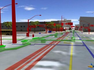
SPAR 2013: Developing an intelligent 3D model of above and below ground infrastructure for the City of Las Vegas

22 April 2013 Geoff Zeiss

At SPAR 2013 Keith Warren, BIM/3D SUE Manager at VTN Consulting gave a fascinating presentation on the 3D above and below ground model of city infrastructure including roads, utilities, telecom, and buildings that VTN has […]

Augmented reality

New directions for geospatial standards: augmented reality, citizen observatories, and the Internet of Things

2 October 2012 Geoff Zeiss

I have frequently blogged about some of the important geospatial standards that have been fostered by the Open Geospatial Consortium, most recently about a new Energy and Utilities Domain Working Group (DWG) for the electric, […]

3D Visualization

Augmented reality technology preview

10 August 2012 Geoff Zeiss

There is a new technology preview at Autodesk Labs, Augmented Reality for Showcase.  Augmented reality makes it possible to overlay information (graphics, text, video, sound) on to a live video feed of the real-world in […]

Posts pagination

« 1 2 3

Events

Feb 24
5:30 pm - 7:30 pm

Kelowna Mural Map – User Feedback & Networking Social

Feb 24
6:30 pm - 8:30 pm

February Ottawa GoGeomatics Meetup

Feb 25
All day

Government Cybersecurity Showcase Federal 2026

Mar 1
March 1 - March 4

PDAC Convention 2026

Mar 10
March 10 - March 13

2026 ABCLS Conference and 121st Annual General Meeting

View Calendar

View All Events

Services

  • Post a Job
  • Post an Ad
  • Post an Event
  • Post a Directory Listing
  • Post a Press Release
  • Media Kit
  • My Account
  • Login

Jobs

Post a Job
  • Volunteer Editorial Contributor – Be Part of Canada’s Geomatics Story
    Remote
  • Junior Geomatics Field Technician – Technical Surveys
    Montréal, QC
  • GIS Specialist
    Amherst, Nova Scotia
  • Precast Structural BIM Specialist
    Calgary, Alberta
View All Jobs
  • Directories
    • Associations Directory
    • Industry Directory
    • Education Programs
    • Open Data
  • Volunteer
    • Start a GoGeomatics Group
    • Editors & Writers Group
  • About Us
    • GoGeomatics Media Kit
    • Who We Are
    • Contact Us
    • FAQ’s
    • Advertising
    • Marketing
  • Subscribe
GoGeomatics
GoGeomatics is the largest and most popular communications hub promoting the Canadian geospatial community. The business was incorporated in 2011. GoGeomatics hosts over 100 fun, free, location technology networking events each year in cities across Canada.

© 2026 GoGeomatics

  • facebook
  • Twitter
  • Linkedin
  • Youtube
  • Linkedin Group