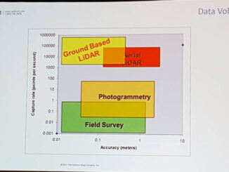
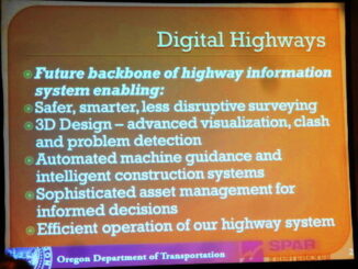
• facebook
  • Twitter
  • Linkedin
  • Youtube
  • Linkedin Group
  • Post a Job
  • Post an Ad
  • Post an Event
  • Post a Directory Listing
  • Post a Press Release
  • Media Kit
  • My Account
  • Login
GoGeomatics
  • MAGAZINE
    • BIM & GIS
    • Community
    • Conference news
    • Earth Observation
    • Education & Careers
    • GEOAI
    • Announcements
    • Reality Capture & Lidar
    • Science
    • Technology
    • Between the Poles
  • Directories
    • ASSOCIATION
    • INDUSTRY
    • EDUCATION
    • Open Data
  • EVENTS
    • GeoIgnite Events
    • Events Calendar
    • GoGeomatics Meetups
  • Services
    • Advertising
    • Marketing
    • Post a Job
    • Post an Ad
    • Post an Event
    • Post a Press Release
    • Post a Directory Listing
    • Media Kit
    • Web Design
  • Find a Job
  • Volunteer
    • Start a GoGeomatics Group
    • Editors & Writers Group
  • About Us
    • About Us
    • Contact Us
    • Frequently Asked Questions
  • Videos
HomeBetween the Poles – The Geoff Zeiss ArchivesAutonomous vehicles

Autonomous vehicles

3D data

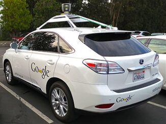
Developing high precision highway maps for autonomous vehicles

11 July 2019 Geoff Zeiss

Currently autonomous vehicles with some exceptions rely on on-board sensors for the detailed aspects of navigation. But many believe that high precision maps, which contain significantly more detailed information and true-ground-absolute accuracy than current road […]

3D data

Fully automated classification of road and highway features for autonomous vehicles

12 October 2017 Geoff Zeiss

Point clouds are fine for visualization to provide context, but to be really useful they need to be classified.  Feature extraction, as the process is often referred to,  is currently a mostly manual process that […]

3D data

Autonomous UAVs using SLAM to navigate without GPS

6 April 2017 Geoff Zeiss

I have just spent an incredible three days in Houston at the SPAR3D 2017 conference.  There is so much going on right now in the 3D world with several key technologies just coming to fruition […]

3D cadastre

SPAR2016: Digitalizing highway construction at the Oregon DoT

8 June 2016 Geoff Zeiss

At SPAR 2013Ron Singh, Engineering Automation Manager/Chief of Surveys, Oregon Department of Transportation (DoT) made a startling proposal that would stand the traditional highway construction process on its head by making the post-construction as-built survey […]

Autonomous vehicles

Autonomous vehicles forecast to be commercially available by 2020

15 July 2014 Geoff Zeiss

Google has had a fleet of 10 or more driverless cars on the roads in Florida, Nevada, and California for a couple of years that by now have logged over a million driverless miles.  The […]

3D Visualization

SPAR 2013: Digital highways require integrated engineering and geospatial data

16 April 2013 Geoff Zeiss

At SPAR 2013 I had the opportunity to hear very forward looking presentations by Ron Singh, Chief of Surveys/Geometronics Manager at the Oregon Department of Transportation.  What Ron sees in the future and what motivates […]

Asset management

SPAR 2013: Turning the construction process on its head

16 April 2013 Geoff Zeiss

At SPAR 2013 I had the opportunity to hear a very forward looking presentation by Ron Singh, Chief of Surveys/Geometronics Manager at the Oregon Department of Transportation.  It was even more impressive because Ron’s background […]

Events

Mar 10
March 10 - March 13

2026 ABCLS Conference and 121st Annual General Meeting

Mar 18
6:30 pm - 8:30 pm

Vancouver GoGeomatics Meetup

Mar 24
5:30 pm - 7:30 pm

GoGeomatics Kelowna Meetup — Maps Made Easy & Construction Drone Mapping

Mar 24
6:00 pm - 7:30 pm

GIS Industry and Information Night at Algonquin College

Mar 24
6:00 pm - 8:00 pm

Calgary GoGeomatics March Social

View Calendar

View All Events

Services

  • Post a Job
  • Post an Ad
  • Post an Event
  • Post a Directory Listing
  • Post a Press Release
  • Media Kit
  • My Account
  • Login

Jobs

Post a Job
  • GIS Technologist II
    Fernie, B.C.
  • GIS I TECHNOLOGIST
    Fernie, B.C.
  • Operations Spatial Data Assistant (Contract)
    Vaughan
  • GIS Analyst
    Saint John, New Brunswick
View All Jobs
  • Directories
    • Associations Directory
    • Industry Directory
    • Education Programs
    • Open Data
  • Volunteer
    • Start a GoGeomatics Group
    • Editors & Writers Group
  • About Us
    • GoGeomatics Media Kit
    • Who We Are
    • Contact Us
    • FAQ’s
    • Advertising
    • Marketing
  • Subscribe
GoGeomatics
GoGeomatics is the largest and most popular communications hub promoting the Canadian geospatial community. The business was incorporated in 2011. GoGeomatics hosts over 100 fun, free, location technology networking events each year in cities across Canada.

© 2026 GoGeomatics

  • facebook
  • Twitter
  • Linkedin
  • Youtube
  • Linkedin Group