
There is a fascinating news item on NPR radio about stimulus money going to virtual shovel-ready projects which is really worth listening to.
Gaming Technology
One of the things I like to mention when I’m speaking at conferences is about gaming. Many people and many people’s children have spent a lot of time with a PSP, Wii, or Xbox. I think it is fair to say that this time is often considered not to have a lot of socially redeeming value, pure entertainment at best.
Convergence
But the gaming industry is huge and as a result a lot of investment has flowed into gaming technology, both hardware and software. A primary result has been the development of incredibly good 3D graphics. The good news for gamers and for parents of gamers is that this technology is now being put to “better” use. The same technology that is used to animate films like Lord of the Rings is being used by architects and engineers to visualize and simulate construction projects digitally before they are built. Because 3d gaming technology is used, these simulations are dynamic and interactive, in other words you can experience cars, trams, trains, and other vehicles moving. They are also photorealistic. The combination is such a real experience that I often have to repeatedly assure people in the audience watching one of these simulation videos that is a simulation not a movie.
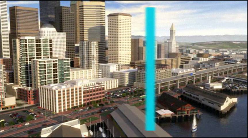 My favorite simulation video is one that was made by Parsons Brinckerhoff (PB), a large engneering company, for the City of Seattle for the Alaskan Way project. The Alaskan Way is an elevated freeway that runs along the Seattle waterfront, between the Pike Street market and the harbor. Not only does it detract from the waterfront experience, it is at serious risk in case of an earthquake, and this is the West Coast, one of the seismically very active places in the world. PB had developed a 3D city model for the city of Seattle into which they integrated the engineering designs for two alternatives for replacing the existing Alaskan Way freeway, one underground and the other above ground. They then created a short video using gaming technolgy (3ds Max) to simulate what the two alternatives would look like, from a tourist perspective and also from the prespective of a driver. This is an excellent example, to paraphrase a well-known aphorism, where a 2 minute simulation video is worth a thousand engineering drawings, in conveying to non-technical people including politicians and citizens what the impact of a major engineering project would be.
Be the first to comment