• facebook
  • Twitter
  • Linkedin
  • Youtube
  • Linkedin Group
  • Post a Job
  • Post an Ad
  • Post an Event
  • Post a Directory Listing
  • Post a Press Release
  • Media Kit
  • My Account
  • Login
GoGeomatics
  • MAGAZINE
    • BIM & GIS
    • Community
    • Conference news
    • Earth Observation
    • Education & Careers
    • GEOAI
    • Announcements
    • Reality Capture & Lidar
    • Science
    • Technology
    • Between the Poles
  • Directories
    • ASSOCIATION
    • INDUSTRY
    • EDUCATION
    • Open Data
  • EVENTS
    • GeoIgnite Events
    • Events Calendar
    • GoGeomatics Meetups
  • Services
    • Advertising
    • Marketing
    • Post a Job
    • Post an Ad
    • Post an Event
    • Post a Press Release
    • Post a Directory Listing
    • Media Kit
    • Web Design
  • Find a Job
  • Volunteer
    • Start a GoGeomatics Group
    • Editors & Writers Group
  • About Us
    • About Us
    • Contact Us
    • Frequently Asked Questions
  • Videos
HomeBetween the Poles – The Geoff Zeiss ArchivesConvergence

Convergence

3D data

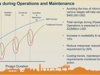
3D BIM + geospatial full lifecycle metro rail project aims at eliminating data loss

27 December 2018 Geoff Zeiss

This year’s winner of a special recognition award at Year in Infrastructure was Maharashtra Metro Rail Corporation Ltd for its Nagpur Metro Asset Information Management System which implemented a digital twin and a tagging scheme […]

Between the Poles – The Geoff Zeiss Archives

Firm realizes ROI of 203% by integrating CAD and GIS for fiber network management

18 December 2018 Geoff Zeiss

Integrating CAD and GIS into an efficient workflow for records management (aka network documentation) has been a challenge for utility and telecom operators for decades.  While utility and telecom operators have found ways to address […]

3D data

BIM and reality modeling eliminate change orders for brownfield substation expansion

11 December 2018 Geoff Zeiss

Companies are recognizing the benefits of an integrated geospatial and building information modeling (BIM) approach to design and construction. At Bentley‘s the Year in Infrastructure 2018 Conference in London, the winner of the Year in Infrastructure […]

Between the Poles – The Geoff Zeiss Archives

ESRI and Autodesk partnership for BIM and geospatial interoperability: one year later

27 November 2018 Geoff Zeiss

The BIM and geospatial interoperability challenge is the latest symptom of the broader problem of integrating AEC and geospatial workflows, that has contributed to low productivity in the construction sector. After the announcement about a […]

Between the Poles – The Geoff Zeiss Archives

IoT platform for integrating two decades of Hexagon’s technology acquisitions announced at HxGNLIve

13 June 2018 Geoff Zeiss

In May of last year Hexagon acquired a company based in Alpharetta, Georgia called Catavolt that combines internet of things (IoT), analytics and mobility. At HxGNLIve in Las Vegas Ola Rollén in his exhilarating opening […]

3D data

National digital twin is key to the UK government’s transformation of the construction industry

31 May 2018 Geoff Zeiss

The conjunction of the release of three UK government reports, Industrial Strategy Building A Britiain Fir for the Future, Transforming Infrastructure Performance, and Data for the Public Good, has set the stage for a transformation in […]

3D data

Top construction company AECOM applies BIM + geospatial for full lifecycle projects

18 January 2018 Geoff Zeiss

AECOM is a US$18.2 billion a year firm in the construction sector.  It designs and builds infrastructure around the world for public- and private-sector clients including transportation, facilities, environmental, energy, oil and gas, water, high-rise […]

3D data

An open source web-based platform for integrating BIM and 3D geospatial

1 December 2017 Geoff Zeiss

BIM+geospatial integration is being driven by a trend toward infrastructure construction projects that require maintenance and/or operations during an extended period post-construction.  At the GEO|Design+BIM conference in Amsterdam, Sanghee Shin, CEO of Gaia3D Inc., gave […]

Posts pagination

« 1 2 3 … 11 »

Events

Feb 24
All day

Digital Leadership Day Federal

Feb 24
February 24 - February 26

Government Innovation Week – Federal

Feb 24
5:30 pm - 7:30 pm

GoGeomatics Kelowna February Social

Feb 24
5:30 pm - 7:30 pm

Kelowna Mural Map – User Feedback & Networking Social

Feb 24
6:30 pm - 8:30 pm

February Ottawa GoGeomatics Meetup

View Calendar

View All Events

Services

  • Post a Job
  • Post an Ad
  • Post an Event
  • Post a Directory Listing
  • Post a Press Release
  • Media Kit
  • My Account
  • Login

Jobs

Post a Job
  • Volunteer Editorial Contributor – Be Part of Canada’s Geomatics Story
    Remote
  • Junior Geomatics Field Technician – Technical Surveys
    Montréal, QC
  • GIS Specialist
    Amherst, Nova Scotia
  • Precast Structural BIM Specialist
    Calgary, Alberta
View All Jobs
  • Directories
    • Associations Directory
    • Industry Directory
    • Education Programs
    • Open Data
  • Volunteer
    • Start a GoGeomatics Group
    • Editors & Writers Group
  • About Us
    • GoGeomatics Media Kit
    • Who We Are
    • Contact Us
    • FAQ’s
    • Advertising
    • Marketing
  • Subscribe
GoGeomatics
GoGeomatics is the largest and most popular communications hub promoting the Canadian geospatial community. The business was incorporated in 2011. GoGeomatics hosts over 100 fun, free, location technology networking events each year in cities across Canada.

© 2026 GoGeomatics

  • facebook
  • Twitter
  • Linkedin
  • Youtube
  • Linkedin Group