• facebook
  • Twitter
  • Linkedin
  • Youtube
  • Linkedin Group
  • Post a Job
  • Post an Ad
  • Post an Event
  • Post a Directory Listing
  • Post a Press Release
  • Media Kit
  • My Account
  • Login
GoGeomatics
  • MAGAZINE
    • BIM & GIS
    • Community
    • Conference news
    • Earth Observation
    • Education & Careers
    • GEOAI
    • Announcements
    • Reality Capture & Lidar
    • Science
    • Technology
    • Between the Poles
  • Directories
    • ASSOCIATION
    • INDUSTRY
    • EDUCATION
    • Open Data
  • EVENTS
    • GeoIgnite Events
    • Events Calendar
    • GoGeomatics Meetups
  • Services
    • Advertising
    • Marketing
    • Post a Job
    • Post an Ad
    • Post an Event
    • Post a Press Release
    • Post a Directory Listing
    • Media Kit
    • Web Design
  • Find a Job
  • Volunteer
    • Start a GoGeomatics Group
    • Editors & Writers Group
  • About Us
    • About Us
    • Contact Us
    • Frequently Asked Questions
  • Videos
HomeBetween the Poles – The Geoff Zeiss ArchivesConvergence

Convergence

3D data

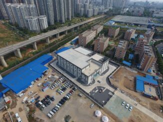
Be Inspired Awards 2016: Full lifecyle digital modeling of a substation in a congested urban area

23 November 2016 Geoff Zeiss

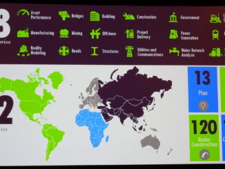
At the Year in Infrastructure 2016 conference in London, the Be Inspired Awards attracted over 300 submissions.  Many of these were impressive in how they applied digital technology to designing, constructing and maintaining buildings and […]

No Picture
3D data

Geospatial and BIM will be key to transforming construction

21 November 2016 Geoff Zeiss

In a recent report, Imagining construction’s digital future, McKinsey & Company suggests that the construction industry is ripe for disruption and two of the technologies that it believes will be key in that anticipated transformation […]

Between the Poles – The Geoff Zeiss Archives

Be Inspired Awards 2016 reveal rapid adoption of reality capture in construction

31 October 2016 Geoff Zeiss

At the Year in Infrastructure 2016 conference in London the Be Inspired Awards set some new records. There were 311 submissions from 22 countries.  Of these 110 were completed and operational projects and 120 were under […]

3D data

Development of an open spatially-enabled BIM query language

25 October 2016 Geoff Zeiss

Introduction Building Information Models are comprehensive digital representations of buildings which include 3D geometry and associated data. They are widely used for designing, engineering, and constructing buildings (vertical BIM) and infrastructure (horizontal BIM). Owners are […]

3D data

HxGN Live: 3D underground utility mapping, indoor mapping, UAVs and utility solutions

21 June 2016 Geoff Zeiss

Last week I had the opportunity to present at the annual Hexagon conference HxGN Live in Anaheim. Hexagon is a rapidly growing company with broad technology reach with core strengths in geospatial surveying and laser […]

3D data

Spar 3D: 3D mapping the inside of multi-story buildings with a backpack

5 May 2016 Geoff Zeiss

At the Spar 3D Expo and Conference in Houston The Woodlands, Texas, Avideh Zakhor from the University of California Berkeley was onsite with some remarkable products from her new startup Indoor Reality.  I blogged previously […]

3D data

SPAR2016: Geo-coordination key to convergence of engineering and 3D technology

3 May 2016 Geoff Zeiss

We are seeing the convergence of engineering and architecture with 3D technology and this is enabling a full lifecycle perspective in designing and constructing infrastructure where we not only aim at better project delivery, but […]

Analytics

GeoBuiz 2016: Geospatial and consumer devices, reality modeling, big data and analytics

2 May 2016 Geoff Zeiss

Reality modeling In the future, the deliverables at the end of a construction project will not only include the completed building itself, but also a digital “reality model” of the structure.  The digital model will […]

Posts pagination

« 1 … 3 4 5 … 11 »

Events

Apr 21
6:00 pm - 8:00 pm

Calgary GoGeomatics April Social

Apr 22
April 22 - April 23

11th Annual Digitalization & AI in Energy Canada Conference

Apr 27
April 27 - April 30

Welcome to the Canadian Hydrographic Conference 2026

May 3
May 3 @ 8:00 am - May 6 @ 5:00 pm

GEOINT Symposium 2026

May 11
May 11 @ 8:00 am - May 13 @ 5:00 pm

GeoIgnite 2026

View Calendar

View All Events

Services

  • Post a Job
  • Post an Ad
  • Post an Event
  • Post a Directory Listing
  • Post a Press Release
  • Media Kit
  • My Account
  • Login

Jobs

Post a Job
  • Volunteer Editorial Contributor – Be Part of Canada’s Geomatics Story
    Remote
  • Junior Geomatics Field Technician – Technical Surveys
    Montréal, QC
  • GIS Specialist
    Amherst, Nova Scotia
  • Precast Structural BIM Specialist
    Calgary, Alberta
View All Jobs
  • Directories
    • Associations Directory
    • Industry Directory
    • Education Programs
    • Open Data
  • Volunteer
    • Start a GoGeomatics Group
    • Editors & Writers Group
  • About Us
    • GoGeomatics Media Kit
    • Who We Are
    • Contact Us
    • FAQ’s
    • Advertising
    • Marketing
  • Subscribe
GoGeomatics
GoGeomatics is the largest and most popular communications hub promoting the Canadian geospatial community. The business was incorporated in 2011. GoGeomatics hosts over 100 fun, free, location technology networking events each year in cities across Canada.

© 2026 GoGeomatics

  • facebook
  • Twitter
  • Linkedin
  • Youtube
  • Linkedin Group